
Ontario Highway 21 facts for kids
Quick facts for kids
|
||||||||||
|---|---|---|---|---|---|---|---|---|---|---|
| Bluewater Highway | ||||||||||
|
Highway 21 highlighted in red
|
||||||||||
| Route information | ||||||||||
| Maintained by the Ministry of Transportation of Ontario | ||||||||||
| Length | 226.8 km (140.9 mi) | |||||||||
| Existed | May 23, 1927–present | |||||||||
| Major junctions | ||||||||||
| South end | ||||||||||
| North end | ||||||||||
| Location | ||||||||||
| Major cities: | Grand Bend, Goderich, Kincardine, Southampton, Port Elgin, Owen Sound | |||||||||
| Highway system | ||||||||||
|
||||||||||

Ontario Highway 21, also called King's Highway 21, is a provincial highway in southwestern Ontario, Canada. It starts near Ontario Highway 402, almost half way between Sarnia and London. It runs north/northeast for 227 kilometres (141 mi) and ends in Owen Sound with Highway 6, Highway 10, and Highway 26. The roadway is referred to as the Bluewater Highway because it remains very close to the eastern shoreline of Lake Huron. It was started in 1927 as Highway 3 running across Kent and Lambton Counties. In 1930 it was extended and renamed King's Highway 21. It is one of Ontario's most treacherous roads for winter driving. Highway 21 is frequently closed during winter because of snow blowing off Lake Huron.
Images for kids
-
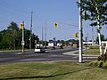
Southbound Highway 21 and northbound Highway 6 are concurrent in Owen Sound, the only example of a wrong-way concurrency in the provincial highway network.
-
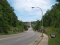
Highway 21 and Highway 6 descend the Niagara Escarpment into Owen Sound.
-
Highways 21 and 6 form the only wrong-way concurrency in the Ontario highway network.
-
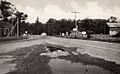
Highway 21 in Port Franks at the junction of what was then Highway 82
-
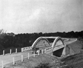
Highway 21 near Petrolia. A Bowstring Arch bridge was constructed to replace the existing county-built bridge shortly after the department designated Highway 21.
-
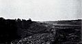
Excavation work to bypass Highway 21 north of the Maitland River near Goderich


