
Ontario Highway 26 facts for kids
Quick facts for kids
|
||||||||||
|---|---|---|---|---|---|---|---|---|---|---|
| Lua error in Module:Infobox_road/map at line 15: attempt to index field 'wikibase' (a nil value). | ||||||||||
| Route information | ||||||||||
| Maintained by the Ministry of Transportation of Ontario | ||||||||||
| Length | 113.7 km (70.6 mi) | |||||||||
| Existed | July 2, 1927–present | |||||||||
| Major junctions | ||||||||||
| West end | ||||||||||
| Hurontario Street | ||||||||||
| East end | ||||||||||
| Location | ||||||||||
| Major cities: | Owen Sound, Barrie | |||||||||
| Towns: | Meaford, Collingwood, Wasaga Beach, Stayner (in Clearview) | |||||||||
| Highway system | ||||||||||
|
||||||||||

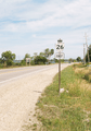
Ontario Highway 26, also called King's Highway 26, is a provincial highway in Ontario, Canada. It goes along the southern shoreline of Georgian Bay. It starts in Owen Sound with the intersection of Highway 6, Highway 10, and Highway 21. It then goes eastward and ends in Barrie at the intersection with Highway 400.
Highway 26 is 113.7 kilometers (70.6 miles) long. It is part of a major transportation link, along with Highway 400, between the Greater Toronto Area and Georgian Bay.
Images for kids
-
Highway 26 facing west towards Owen Sound; the highway dives through several large valleys between here and Meaford.
-
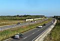
The Highway 26 bypass between Collingwood and Wasaga Beach
-
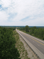
A large valley between Owen Sound and Meaford
-
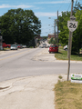
Highway 26 facing north through Meaford
-
Highway 26 serves the southern shoreline of Georgian Bay, but seldom comes within eyesight of it. This section southeast of Thornbury is one of the few exceptions.
-
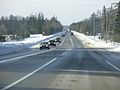
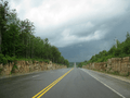
Highway 26 in Springwater, facing west


