
Pokhara facts for kids
Quick facts for kids
Pokhara Metropolitan City
पोखरा महानगरपालिका
|
|
|---|---|

(From left) Top: Tal Barahi Temple, Boats in Phewa Lake; Center: View of the Annapurna Range from Pokhara; Bottom: Bindhyabasini temple, Pokhara Town, i Stupa, Pokhara in Pokhara.
|
|
| Nickname(s):
city of Eight lakes
|
|
| Motto(s):
Clean Pokhara, Green Pokhara
|
|

Pokhara
Location in Nepal
|
|
| Country | Nepal |
| Province | Gandaki Pradesh |
| District | Kaski District |
| Incorporated | 1962 |
| Area | |
| • Total | 464.24 km2 (179.24 sq mi) |
| • Water | 4.4 km2 (1.7 sq mi) |
| Elevation | 1,400 m (4,600 ft) |
| Highest elevation | 1,740 m (5,710 ft) |
| Lowest elevation | 827 m (2,713 ft) |
| Population
(2011)
|
|
| • Total | 402,995 |
| • Density | 868.074/km2 (2,248.30/sq mi) |
| • Ethnicities | Brahmin Gurung Chhetri Khas Nepali Magar Newar |
| • Religions | Hinduism Buddhism Muslim Christian |
| Languages | |
| • Official | Nepali and Gurung Bhasaa(Gurung Language) |
| Time zone | UTC+5:45 (NST) |
| Postal Code |
33700 (WRPD), 33702, 33704, 33706, 33708, 33713
|
| Area code(s) | 061 |

Pokhara (Nepali: पोखरा) is a metropolitan city in Nepal which is situated in Gandaki Pradesh province of Nepal. The country's second largest city, in terms of population, and, largest city, in terms of area, it is the capital of Gandaki Pradesh. The city also serves as the headquarters of Kaski District. Pokhara is located 200 kilometres (120 miles) west of the capital Kathmandu. The altitude varies from 827 metres (2,713 feet) in the southern part to 1,740 metres (5,710 feet) in the north. The Annapurna Range, with three out of the ten highest mountains in the world — Dhaulagiri, Annapurna I and Manaslu — is within 15–35 mi (24–56 km) of the valley.
Pokhara is considered the tourism capital of Nepal, being a base for trekkers undertaking the Annapurna Circuit through the Annapurna Conservation Area region of the Annapurna ranges in the Himalayas. The city is also home to a large number of the elite Gurkha soldiers.
Geography
Pokhara is in the northwestern corner of the Pokhara Valley, which is a widening of the Seti Gandaki valley that lies in the region (Pahad) of the Himalayas. In this region the mountains rise very quickly, and within 30 kilometres (19 miles), the elevation rises from 1,000 to 7,500 metres (3,300 to 24,600 feet). As a result of this sharp rise in altitude the area of Pokhara has one of the highest precipitation rates in the country (3,350 mm/year or 131 inches/year in the valley to 5600 mm/year or 222 inches/year in Lumle). Even within the city there is a noticeable difference in rainfall between the south and the north: The northern part at the foothills of the mountains experiences a proportionally higher amount of precipitation.
The Seti Gandaki is the main river flowing through the city. The Seti Gandaki (White Gandaki) and its tributaries have created several gorges and canyons in and around Pokhara that give intriguingly long sections of terrace features to the city and surrounding areas. These long sections of terraces are interrupted by gorges that are hundreds of metres deep. The Seti gorge runs through Pokhara from north to south and then west to east; at places these gorges are only a few metres wide. In the north and south, the canyons are wider.
In the south, the city borders Phewa Tal (4.4 km2) at an elevation of about 827 metres (2,713 feet) above sea level, while Lumle at 1,740 metres (5,710 feet) in the north touches the base of the Annapurna mountain range. Pokhara, the city of lakes, is the second largest city of Nepal after Kathmandu. Three 8,000-metre (26,000-foot) peaks (Dhaulagiri, Annapurna, Manaslu) can be seen from the city. The Machhapuchchhre (Fishtail) with an elevation of 6,993 metres (22,943 feet) is the closest to the city.
The porous underground of the Pokhara valley favours the formation of caves and several caves can be found within city limits. In the south of the city, a tributary of the Seti flowing out of the Phewa Lake disappears at Patale Chhango (पाताले छाँगो, Nepali for Hell's Falls, also called Davis Falls, after someone who supposedly fell in) into an underground gorge, to reappear 500 metres (1,600 feet) further south.
Climate
The city has a humid subtropical climate; however, the elevation keeps temperatures moderate. Temperatures in summer average between 25 and 35 °C; in winter around −2 to 15 °C. Pokhara and nearby areas receive a high amount of precipitation. Lumle, 25 miles from Pokhara city center, receives the highest amount of rainfall (> 5600 mm/year or 222 inches/year) in the country. Snowfall is not observed in the valley, but surrounding hills experience occasional snowfall in the winter. Summers are humid and mild; most precipitation occurs during the monsoon season (July–September). Winter and spring skies are generally clear and sunny. The highest temperature ever recorded in Pokhara was 38.5 °C (101.3 °F) on 4 May 2013, while the lowest temperature ever recorded was 0.5 °C (32.9 °F) on 13 January 2012 .
Temples and Gumbas


There are numerous temples and gumbas in and around pokhara valley. Many temples serve as combined places of worship for Hindus and Buddhists. Some of the popular temples and Gumbas are:
- Tal Barahi Temple (located on the island in the middle of Phewa Lake)
- Bindhyabasini Temple
- Radha Krishna Shanti Ashram Lame Al
- Sitaldevi Temple
- Gupteshwar Mahadev Gupha (Cave)/Temple
- Mudula Karki Kulayan Mandir
- Sunpadeli Temple (Kaseri)
- Bhadrakali Temple
- Kumari Temple
- Akala Temple
- Kedareshwar Mahadev Mani Temple
- Matepani Gumba
- World peace pagoda
- Akaladevi Temple
- Monastery (Hemja)
- Nepal Christiya Ramghat Church, established in 1952 (2009 BS), in Ramghat area of Pokhara is also the first church in Nepal.
Tourism and economy


After the occupation of Tibet by China in 1950 and the Indo-China war in 1962, the old trading route to India from Tibet through Pokhara became defunct. Today only a few caravans from Mustang arrive in Bagar.
In recent decades, Pokhara has become a major tourist destination: it is considered the tourism capital of Nepal in South Asia, mainly for adventure tourism and the base for the famous Annapurna Circuit trek. Thus, a major contribution to the local economy comes from the tourism and hospitalities industry. Tourism is a major source of income for local people and the city. There are two 5-star hotels and approximately 305 other hotels that includes five 3-star, fifteen 2-star and non-star hotels in the city.
Many medieval era temples (Barahi temple, Bindhyabasini, Bhadrakali, Talbarahi, Guheshwari, Sitaldevi, Gita mandir temple, Bhimsen temple) and old Newari houses are part of the city (Bagar, Bindhyabasini, Bhadrakali, Bhairab Tol, etc.). The modern commercial city centres are at Chipledhunga, New Road, Prithvi Chok and Mahendrapul (recently renamed as Bhimsen Chok).
The city promotes two major hilltops as viewpoints to see the city and surrounding panorama: World Peace Pagoda, built in 1996 across the southern shore of Phewa lake and Sarangkot, which is northwest of the city. In February 2004, International Mountain Museum (IMM) was opened for public in Ratopahiro to boost the city's tourism attractions. Other museums are Pokhara Regional Museum; an ethnographic museum; Annapurna Natural History Museum which houses preserved specimens of flora and fauna, and contains particularly extensive collection of the butterflies, found in the Western and ACAP region of Nepal; and Gurkha Museum featuring history of the Gurkha soldiers.
The city has recently been adorned with a bungee jumping site (the second in Nepal): Water Touch Bunjee Jumping. A cable car service has begun construction joining Phewa Lake with World Peace Stupa led by the government of Nepal which is expected to boost the tourism exponentially.
Since the 1990s, Pokhara has experienced rapid urbanization. As a result, service-sector industries have increasingly contributed to the local economy overtaking the traditional agriculture. An effect of urbanization is seen in high real estate prices, among the highest in the country. The major contributors to the economy of Pokhara are manufacturing and service sector including tourism; agriculture and the foreign and domestic remittances. Tourism, service sector and manufacturing contributes approximately 58% to the economy, remittances about 20% and agriculture nearly 16%.Also, following are some major companies and institutions located in Pokhara:
- Ncell centre, Srijana Chok (Opposite to Heritage College)
- Nepal Telecom, Ranipauwa and Mahendrapul and Damside
- Nepal Rastra Bank, Rastra Bank Chok (Southern End of Lakeside)
- Nabil Bank, Sabhagriha Chok (New Road)
- Nepal Red Cross Society, Srijana Chok
Images for kids
-
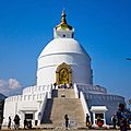
World peace pagoda
-
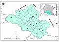
Wards of Pokhara
-
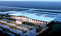
View of the new Pokhara International Airport
-
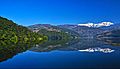
Begnas lake lies in the east of Pokhara valley


See also
 In Spanish: Pokhara para niños
