
Rideau Canal facts for kids
Quick facts for kids Rideau Canal |
|
|---|---|
| Native names English: Rideau Canal French: Canal Rideau |
|

Locks in summer
|
|
| Area | Ontario |
| Length | 202 km (126 mi) |
| Built | 1832 |
| Architect | John By |
| Governing body | Parks Canada |
| Type | Cultural |
| Criteria | i, iv |
| Designated | 2007 (31st session) |
| Reference no. | 1221 |
| State Party | Canada |
| Region | North America |
| Designated | 1925 |
| Canadian Heritage River | 2000 |
| Rideau Canal | |
|---|---|
| Specifications | |
| Length | 202 km (126 miles) |
| Maximum boat length | 90 ft 0 in (27.43 m) |
| Maximum boat beam | 28 ft 0 in (8.53 m) |
| Maximum boat draft | 1.5 m (5 ft) |
| Locks | 47 |
| Status | Open |
| History | |
| Construction began | 1826 |
| Date completed | 1832 |
| Geography | |
| Start point | Ottawa River |
| End point | Lake Ontario |
The Rideau Canal, also known unofficially as the Rideau Waterway, connects Canada's capital city of Ottawa, Ontario, to Lake Ontario and the Saint Lawrence River at Kingston. It is 202 kilometres long. The name Rideau, French for "curtain", is derived from the curtain-like appearance of the Rideau River's twin waterfalls where they join the Ottawa River. The canal system uses sections of two rivers, the Rideau and the Cataraqui, as well as several lakes. Parks Canada operates the Rideau Canal.
The canal was opened in 1832 as a precaution in case of war with the United States. It remains in use today primarily for pleasure boating, with most of its original structures intact. The locks on the system open for navigation in mid-May and close in mid-October. It is the oldest continuously operated canal system in North America. In 2007 it was registered as a UNESCO World Heritage Site.
Contents
History

Plan
After the War of 1812, information was received about the United States' plans to invade the British colony of Upper Canada from upstate New York by following the St. Lawrence River. This would have severed the lifeline between Montreal and the major naval base at Kingston. To protect against such an attack in the future, the British began construction of a number of defences including Citadel Hill, La Citadelle, and Fort Henry.
To ensure safe passage between Montreal and Kingston, a new route was planned that would proceed westward from Montreal along the St. Lawrence, north along the Ottawa River to Bytown (now Ottawa), then southwest via canal to Kingston and out into Lake Ontario. The Rideau would form the last portion of this route, along with shorter canals at Grenville, Chute-à-Blondeau and Carillon to bypass rapids and other hazards along the route.

Construction
The construction of the canal was supervised by Lieutenant-Colonel John By of the Royal Engineers. Private contractors such as future sugar refining entrepreneur John Redpath, Thomas McKay, Robert Drummond, Thomas Phillips, Andrew White and others were responsible for much of the construction, and the majority of the actual work was done by thousands of Irish and French-Canadian labourers. Colonel John By decided to create a slackwater canal system instead of constructing new channels. This was a better approach as it required fewer workers, was more cost effective, and would have been easier to build.

The canal work started in the fall of 1826, and it was completed by the spring of 1832. The first full steamboat transit of the canal was made by Robert Drummond's steamboat, Rideau (aka "Pumper"), leaving Kingston on May 22, 1832 with Colonel By and family on board, and arriving in Bytown on May 29, 1832.
The final cost of the canal's construction was £822,804 when all the costs, including land acquisition, were accounted for (January 1834). Because of the unexpected cost overruns, John By was recalled to London and was retired; he received no accolades or recognition for his tremendous accomplishment.

Commercial use
Since the canal was completed, no further military engagements have taken place between Canada and the United States. Although the Rideau was not put to defensive use, it played a pivotal role in the early development of Canada and encouraged shipping, trade, and settlement of Upper Canada by tens of thousands of immigrants.
The canal was easier to navigate than the St. Lawrence River because of significant rapids in the river between Montreal and Kingston. As a result, the Rideau Canal became a busy commercial artery between Montreal and the Great Lakes. It was also used by tens of thousands of immigrants from the British Isles heading westward into Upper Canada in this period.
It was a major route for shipping heavy goods (timber, minerals, grain) from Canada's hinterland east to Montreal. Hundreds of barge loads of goods were shipped each year along the Rideau; in 1841, for instance, some 19 steamboats, 3 self-propelled barges, and 157 unpowered or tow barges used the Rideau Canal. The canal had to compete with the Erie Canal through New York State. Some of the shipments that might have been made from Kingston east, instead were taken to the opposite side of the St. Lawrence River to Oswego, New York. There they traveled by the Oswego Canal to reach the Erie and, via the Hudson River, New York City markets.
Businessmen in Kingston studied the issue. They considered building another canal to Lake Simcoe and on to Georgian Bay, thereby enabling traffic on the upper Great Lakes to use canals all the way to Montreal and avoid shipping through the entire lakes system. This plan eventually emerged as the Trent-Severn Waterway. It had originally been surveyed as a military route but never built. A simpler plan was to route around the dangerous parts of the St. Lawrence to allow direct shipping from Kingston to Montreal, and this was soon underway.
By 1849, the rapids of the St. Lawrence had been tamed by a series of locks, and commercial shippers were quick to switch to this more direct route. But commercial use of the Rideau largely ended after the Prescott and Bytown Railway was opened in December 1854. It provided faster service than shipping by the canal.
Further work improving the direct route continued along the St. Lawrence River. In the 1950s it was developed as the current Saint Lawrence Seaway, which allowed ocean-going ships access to the Great Lakes.
Current use
After the arrival of railway routes into Ottawa, most use of the canal was for pleasure craft. The introduction of the outboard motor led to an increase in small pleasure craft and increasing use of inland waterways like the Rideau and Trent-Severn. Today the Rideau forms part of the Great Loop, a major waterway route connecting a large area of the eastern United States and Canada.

Recognition
The Rideau Canal was designated a National Historic Site of Canada in 1925, and marked with a federal plaque the next year, and again in 1962 and 2013.
The canal has been featured on postage stamps issued by Canada Post. Two 45-cent stamps—'Rideau Canal, Summer Boating at Jones Falls' and 'Rideau Canal, Winter Skating by Parliament'—were issued on June 17, 1998, as part of the Canals and Recreational Destinations series. The stamps were designed by Carey George and Dean Martin, based on paintings by Vincent McIndoe. In 2014, the canal appeared on a $2.50 international rate stamp as part of a Canada Post set honoring World Heritage Sites. The same design was reprised on a 2016 domestic-rate stamp.


In 2000 the Rideau Waterway was designated a Canadian Heritage River in recognition of its outstanding historical and recreational values.
In 2007 it was inscribed as a UNESCO World Heritage Site recognizing it as a work of human creative genius. The Rideau Canal was recognized as the best preserved example of a slack water canal in North America demonstrating the use of European slackwater technology in North America on a large scale. It is the only canal dating from the great North American canal-building era of the early 19th century that remains operational along its original line with most of its original structures intact. It was also recognized as an extensive, well preserved and significant example of a canal which was used for military purposes linked to a significant stage in human history – that of the fight to control the north of the American continent.
A plaque was erected by the Ontario Archaeological and Historic Sites Board at Jones Falls Lockstation commemorating Lieutenant Colonel John By, Royal Engineer, the superintending engineer in charge of the construction of the Rideau Canal. The plaque notes the 123-mile-long (198 km) Rideau Canal, built as a military route and incorporating 47 locks, 16 lakes, two rivers, and a 360-foot-long (110 m), 60-foot-high (18.3 m) dam at Jones Falls (Jones Falls Dam), was completed in 1832.
Other plaques to the canal erected by the Ontario Heritage Trust are at Kingston Mills, Smiths Falls, and Rideau Lakes.
Waterway
The 202 kilometres (126 mi) of the Rideau Canal incorporate sections of the Rideau and Cataraqui rivers, as well as several lakes, including the Lower, Upper and Big Rideau lakes. About 19 km (12 mi) of the route is man-made. Communities along the waterway include Ottawa, Manotick, Kars, Burritts Rapids, Merrickville, Smiths Falls, Rideau Ferry, Portland, Westport, Newboro, Seeleys Bay and Kingston. Communities connected by navigable waterways to the Rideau Canal include Kemptville and Perth.
Since World War I and the construction of more extensive rail lines into rural Ontario, only pleasure craft make use of the Rideau Canal. It takes 3–5 days to travel one way through the Rideau Canal system by motor boat. Boat tours of the canal are offered in Ottawa, Kingston, Merrickville, and Chaffeys Lock. A cruise line operates the ship Kawartha Voyageur. Recreational boaters can use it to travel between Ottawa and Kingston.
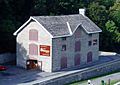
Most of the locks are still hand-operated. There are a total of 45 locks at 23 stations along the canal, plus two locks (locks 33 and 34) at the entrance to the Tay Canal (leading to Perth). Furthermore, there are four blockhouses and some of the original 16 defensible lockmasters residences along the waterway. The original Commissariat Building and foundation of the Royal Engineers' barracks remain at the Ottawa Lock Station. The waterway is home to many species of birds, reptiles, amphibians, mammals and fish.
In 1973–74 a new Smiths Falls Combined Lock, 29a, was built a few dozen metres to the north of the original flight of three locks (locks 28–30). The original locks were bypassed but left in place.
Locks
The Rideau Canal uses a lock system that is still fully functioning. The gates that let boats in and out of the locks last approximately 12–15 years. When the canal was constructed, the gates were made at the lock sites by carpenters and blacksmiths, but presently they are made in Smiths Falls, Ontario, and sometimes it takes up to two months to build a set of gates. The gates used on the Rideau Canal are made of Douglas Fir and are mitre-shaped to ensure a tight seal due to water pressure. The average Rideau Canal lock lift uses 1.3 million litres (1,300 m3; 1,700 cu yd) of water.
Rideaumax
In normal operations the canal can handle boats up to 27.4 m (89 ft 11 in) in length, 7.9 m (25 ft 11 in) in width, and 6.7 m (22 ft) in height with a draft of up to 1.5 m (4 ft 11 in) (boats drafting over 1.2 m (3 ft 11 in) are asked to contact the Rideau Canal Office of Parks Canada prior to their trip). In special circumstances a boat up to 33.5 m (109 ft 11 in) in length by 9.1 m (29 ft 10 in) in width can be handled.
Blockhouses
Four blockhouses were built from 1826 to 1832 to provide protection for the canal was under the control of the British Forces:
- Merrickville Blockhouse – used briefly during 1837 Rebellion, it became a residence for the lockmaster, upper floor removed in 1909 and restored in 1960 as a museum
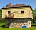
- Kingston Mills Blockhouse – used in 1837–1838, then enlarged to use as a residence, more alterations made in 1909 and restored to 1830 layout in the 1960s
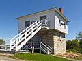
- Newboro Blockhouse – built by the British Ordnance Department, it was also used briefly for its intended military role in the 1830s and then converted to home for lockmaster; restored in 1960s to original blockhouse configuration.
- Rideau Narrows Blockhouse – built by William H. Tett it was also altered in the 19th century to become lockmaster's residence and restored from 1967 to 1970 to its original layout.
A fifth blockhouse at Burritts Rapids was partially built in 1832 before work was stopped with only the foundation and walls completed, then rebuilt in 1914–1915 and finally demolished to be replaced by the current lock station in 1969.
Commissariat Building
The Commissariat Building is the oldest stone building still standing in Ottawa. It was built in 1827 as a storehouse for the British Military in Upper Canada. The building has three floors, a secure vault, two sets of staircases, and a block and tackle on the front for hauling goods into the upper floors. After being divided into workshops and residential apartments, the Commissariat Building has housed the Bytown Museum since 1917.
Parliament Hill was intended to be the site of a fortress, to be called Citadel Hill, where the canal ended at the Ottawa River.
-
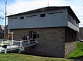
At Merrickville
-
At Kingston Mills
-
At Newboro
-
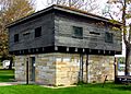
At Rideau Narrows
-
Commissariat Building


Skateway

In winter, a section of the Rideau Canal passing through central Ottawa becomes officially the world's largest and second longest skating rink. The cleared length is 7.8 kilometres (4.8 mi) and has the equivalent surface area of 90 Olympic ice hockey rinks. It runs from the Hartwell locks at Carleton University to the locks between the Parliament Buildings and the Château Laurier, including Dow's Lake in between. It serves as a popular tourist attraction and recreational area and is also the focus of the Winterlude festival in Ottawa. Beaver Tails, a fried dough pastry, are sold along with other snacks and beverages, in kiosks on the skateway.
In January 2008, Winnipeg, Manitoba, achieved the record of the world's longest skating rink at a length of 8.54 kilometres but with a width of only 2 to 3 metres wide on its Assiniboine River and Red River at The Forks. In response, the Rideau Canal was rebranded as "the world's largest skating rink". The Rideau Canal Skateway was added to the Guinness Book of World Records in 2005 for being the largest naturally frozen ice rink in the world.
The Skateway is open 24 hours a day. The length of the season depends on the weather, but typically the Rideau Canal Skateway opens in January and closes in March. Because of global warming, the region's average winter temperature has risen at an accelerating rate since the 1970s, which has gradually pushed back the opening day of skating and shortened the skating season. In 1971–1972, the Skateway's second winter, the skating season was 90 days long, which is the longest season so far. 2015–2016 was the shortest Rideau Canal Skateway season, being a mere 34 days long (and with only 18 skating days).
| Season | Opened | Closed | Days of skating |
|---|---|---|---|
| 51st | January 28, 2021 | February 25, 2021 | 26 |
| 50th | January 18, 2020 | February 26, 2020 | 31 |
| 49th | December 30, 2018 | March 10, 2019 | 59 |
| 48th | January 5, 2018 | February 21, 2018 | 35 |
| 47th | January 14, 2017 | February 18, 2017 | 25 |
| 46th | January 23, 2016 | February 25, 2016 | 18 |
| 45th | January 10, 2015 | March 9, 2015 | 59 |
| 44th | December 31, 2013 | March 11, 2014 | 58 |
| 43rd | January 18, 2013 | February 28, 2013 | 38 |
| 42nd | January 15, 2012 | February 22, 2012 | 26 |
| 41st | January 8, 2011 | March 6, 2011 | 53 |
| 40th | January 14, 2010 | February 26, 2010 | 36 |
| 39th | January 1, 2009 | March 5, 2009 | 58 |
| 38th | January 25, 2008 | March 5, 2008 | 34 |
| 37th | January 26, 2007 | March 12, 2007 | 45 |
| 36th | January 7, 2006 | March 10, 2006 | 39 |
| 35th | December 28, 2004 | March 16, 2005 | 66 |
| 34th | January 14, 2004 | February 28, 2004 | 46 |
| 33rd | January 3, 2003 | March 16, 2003 | 66 |
| 32nd | February 2, 2002 | March 8, 2002 | 26 |
| 31st | December 29, 2000 | March 9, 2001 | 69 |
| 30th | December 31, 1999 | February 23, 2000 | |
| 29th | January 2, 1999 | March 16, 1999 | |
| 28th | December 21, 1997 | March 2, 1998 | 46 |
| 27th | January 12, 1997 | March 22, 1997 | 57 |
| 26th | January 1, 1996 | February 23, 1996 | 47 |
| 25th | January 1, 1995 | March 9, 1995 | 50 |
| 24th | December 30, 1993 | March 11, 1994 | |
| 23rd | December 29, 1992 | March 1, 1993 | |
| 22nd | December 28, 1991 | March 6, 1992 | |
| 21st | January 4, 1991 | March 2, 1991 | |
| 20th | December 24, 1989 | February 22, 1990 | |
| 19th | December 23, 1988 | March 14, 1989 | |
| 18th | January 4, 1988 | March 7, 1988 | |
| 17th | January 7, 1987 | March 2, 1987 | |
| 16th | December 27, 1985 | February 23, 1986 | |
| 15th | January 4, 1985 | February 22, 1985 | |
| 14th | December 25, 1983 | February 17, 1984 | |
| 13th | January 2, 1983 | February 14, 1983 | |
| 12th | December 27, 1981 | February 21, 1982 | |
| 11th | December 18, 1980 | February 17, 1981 | |
| 10th | January 1, 1980 | February 22, 1980 | 43 |
| 9th | January 5, 1979 | February 23, 1979 | |
| 8th | December 29, 1977 | March 9, 1978 | |
| 7th | December 14, 1976 | February 27, 1977 | 45 |
| 6th | December 20, 1975 | February 26, 1976 | |
| 5th | December 31, 1974 | February 28, 1975 | |
| 4th | January 1, 1974 | February 28, 1974 | |
| 3rd | December 25, 1972 | 1973 | 45 |
| 2nd | December 26, 1971 | March 25, 1972 | |
| 1st | January 18, 1971 | February 26, 1971 |
Although some residents of Ottawa used the canal as an impromptu skating surface for years, the official use of the canal as a skateway and tourist attraction is a more recent innovation. As recently as 1970, however, city government of Ottawa considered paving over the canal to make an expressway. The federal government's ownership of the canal, however, prevented the city from pursuing this proposal. When Doug Fullerton was appointed chair of the National Capital Commission, he proposed a recreational corridor around the canal, including the winter skateway between Carleton University and Confederation Park. The plan was implemented on January 18, 1971, despite opposition by city council. A small section of ice near the National Arts Centre was cleared by NCC employees with brooms and shovels, and 50,000 people skated on the canal the first weekend. Today the skating area of the canal is larger because of the equipment available for ice resurfacing and 24/7 maintenance crews. The skateway now has an average of one million visits per year. City councillor and author Clive Doucet credits this transformation of the canal with reinvigorating the communities of the Glebe, Old Ottawa East and Old Ottawa South.

Preparation and maintenance
The preparation for the Skateway starts as early as mid-October. At the end of the boating season, the water is drained at the Ottawa locks near Parliament by Parks Canada. Facilities on the ice such as shelters, chalets, and access ramps for vehicles are then installed. Next, "beams are placed at the locks, and the water is raised to skating level." After this step, the essentials are added such as stairs to access the ice, and hookups for both plumbing and electricity. The ice cap that forms as the canal freezes becomes the Rideau Canal Skateway. When the canal has built up a sufficient ice thickness, snow is removed from the ice surface and it is flooded in order to make the ice even more thick and smooth. Samples of ice are tested for quality and thickness. When it is safe to skate on, the Rideau Canal Skateway is opened for the season.
The Rideau Canal Skateway is maintained by the NCC (National Capital Commission). The ice is maintained by crews 24 hours a day, seven days a week. The snow and ice shavings are cleared off the surface every day and the ice surface is flooded each night with a "water dispersion machine" (weather permitting) to fill in any cracks caused by the contracting and expanding ice. There are approximately 20 holes along the side of the Skateway that flood the ice surface to make it smoother for skaters.
Two types of ice can form on the Rideau Canal Skateway, which are "white ice" and "clear ice". White ice has a milky appearance with air bubbles, and is formed when snow and water mix and then freeze. White ice can also be formed by mechanically flooding the ice surface with water to increase the thickness of the ice cap. The other type of ice is called "clear ice", which has a colourless appearance and is formed when ice crystals build up below the frozen surface in cold temperatures. If snow accumulates on the ice it can negatively impact the conditions for skating. Snow depresses the ice surface and slows down the formation of ice crystals beneath the surface.
Ice conditions can be classified as very good, good, fair or poor. They are updated twice daily by the NCC. The ideal ("very good") conditions mean there are "a limited number of pressure cracks", the ice is very hard and durable overall, the ice surface is clean and smooth, there are a "limited number of rough areas", and there is a "very good gliding surface."
Images for kids
-
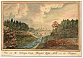
View on the Cataraqui Creek, Brewer's Upper Mills in the background, 1830 by Thomas Burrowes

See also
 In Spanish: Canal Rideau para niños
