
River Meon facts for kids
Quick facts for kids River Meon |
|
|---|---|

River Meon Spring
|
|
| Country | England |
| County | Hampshire |
| Physical characteristics | |
| Main source | Meon Spring East Meon, Hampshire, England 120 metres (390 ft) 50°58′43″N 1°01′30″W / 50.9785°N 1.0249°W |
| River mouth | Hill Head Harbour The Solent, Hampshire, England 0 metres (0 ft) 50°49′06″N 1°14′35″W / 50.8183°N 1.2430°W |
| Length | 34 km (21 mi) |
The River Meon is a chalk stream in Hampshire in the south of England. It rises at East Meon then flows 34 km (21 mi) in a generally southerly direction to empty into the Solent at Hill Head near Stubbington. Above Wickham, the river runs through the South Downs National Park.
Contents
Course
The River Meon rises one mile (1.6 km) south of the village centre of East Meon. It flows due north, then northwest to West Meon, and southwest to Warnford followed by its characteristic, quite straight, south-southwest course, with many tiny wibbles in short stretches. The river descends through the villages of Exton, Corhampton and Meonstoke, Droxford, Wickham, and Titchfield. The river outflows over 2 miles (3.2 km) of estuary through the marshes of the Titchfield Haven National Nature Reserve to enter the Solent through a small harbour at Hill Head. Overall the valley forms the shape of that of a shepherd's crook.
Above the estuary has never been navigable. Titchfield Haven, on the Solent coast was a minor harbour. In the 17th century, the Earl of Southampton caused a sluice (not a canal) to be built (Titchfield Canal) to drain the marshes. The reinstated wetlands form the Titchfield Haven National Nature Reserve.
Gallery
|


Images for kids
-
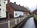
1. East Meon
-

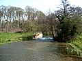
2. The Meon at Warnford
-

3. Bridge over River Meon at Soberton
-
4. Mislingford
-

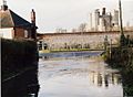
5. Fareham, north of the M27 motorway
-
6. Flooding in Catisfield
-
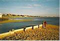
8. River Meon at the Solent
