
Santo Antão, Cape Verde facts for kids
|
Nickname: Ilha das montanhas (island of the mountains)
|
|
|---|---|
 |
|

Santo Antão
Location in Cape Verde
|
|

Santo Antão
Location in Cape Verde
|
|
| Geography | |
| Location | Atlantic Ocean |
| Coordinates | 17°04′12″N 25°10′16″W / 17.070°N 25.171°W |
| Area | 785 km2 (303 sq mi) |
| Length | 42.8 km (26.59 mi) |
| Width | 24.0 km (14.91 mi) |
| Highest elevation | 1,979 m (6,493 ft) |
| Highest point | Tope de Coroa |
| Administration | |
| Concelhos (Municipalities) | Paul, Porto Novo, Ribeira Grande |
| Largest settlement | Porto Novo |
| Demographics | |
| Population | 38,200 (2019) |
| Pop. density | 48.66 /km2 (126.03 /sq mi) |
Santo Antão is the westernmost island of Cape Verde. It is in the Barlavento Islands group. Its population was 38,200 in mid 2019. Its largest city is Porto Novo on the south coast.
The island was discovered in 1461 or 1462 by Diogo Afonso, together with the islands of São Vicente and São Nicolau.
Administrative divisions
The island is divided in three municipalities. These are divided into civil parishes:
- Paul
CV-PA - Porto Novo
CV-PN- São João Baptista
- Santo André
- Ribeira Grande
CV-RG- Nossa Senhora do Rosário
- Nossa Senhora do Livramento
- Santo Crucifixo
- São Pedro Apóstolo
Images for kids
-
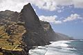
Coastline of Santo Antão
-
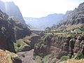
Ribeira da Garça
-
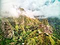
View of the mountains of Vale do Paúl, where terraces plantations can be seen.


See also
 In Spanish: Isla de Santo Antão para niños

All content from Kiddle encyclopedia articles (including the article images and facts) can be freely used under Attribution-ShareAlike license, unless stated otherwise. Cite this article:
Santo Antão, Cape Verde Facts for Kids. Kiddle Encyclopedia.