
Sint-Pieters-Leeuw facts for kids
Quick facts for kids
Sint-Pieters-Leeuw
|
|||
|---|---|---|---|
 |
|||
|
|||
| Country | Belgium | ||
| Region | Flemish Region | ||
| Community | Flemish Community | ||
| Province | Flemish Brabant | ||
| Arrondissement | Halle-Vilvoorde | ||
| Area | |||
| • Total | 40.38 km2 (15.59 sq mi) | ||
| Population
(January 2010)
|
|||
| • Total | 31,572 | ||
| • Density | 781.87/km2 (2,025.04/sq mi) | ||
| Postal codes |
1600-1602
|
||
| Area codes | 02 | ||


Sint-Pieters-Leeuw ( French: Leeuw-Saint-Pierre) is a Dutch-speaking municipality of Belgium located in the province of Flemish Brabant (Flemish Region).
The municipality comprises the towns of Oudenaken, Ruisbroek, Sint-Laureins-Berchem, Sint-Pieters-Leeuw proper and Vlezenbeek. Sint-Pieters-Leeuw is located just outside the Brussels-Capital Region, in the Payottenland. The municipality is a blend of parks, castles, meadows and gardens with the Coloma park as its green heart.
On January 1, 2018, Sint-Pieters-Leeuw had a total population of 34,025. The total area is 40.38 km² which gives a population density of 842 inhabitants per km². It is a mostly a residential community with largely preserved rural areas and some industrial zones.
Images for kids
-
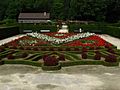
Coloma Rose Garden
-
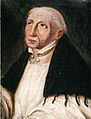
Jan Van Ruusbroec
-
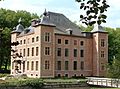
Castle of Coloma, currently the Municipal Cultural Centre
-
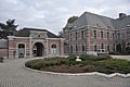
Castle of Wittouck.
-
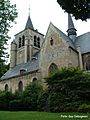
Gothic Saint Peter's Church (15th century)
-
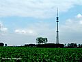
Sint-Pieters-Leeuw Tower
.jpg)


See also
 In Spanish: Sint-Pieters-Leeuw para niños
