
Solon, Maine facts for kids
Quick facts for kids
Solon, Maine
|
|
|---|---|

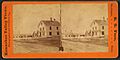
Kennebec River c. 1908
|
|

Solon, Maine
Location in Maine
|
|
| Country | United States |
| State | Maine |
| County | Somerset |
| Incorporated | 1809 |
| Area | |
| • Total | 40.74 sq mi (105.52 km2) |
| • Land | 39.65 sq mi (102.69 km2) |
| • Water | 1.09 sq mi (2.82 km2) |
| Elevation | 499 ft (152 m) |
| Population
(2020)
|
|
| • Total | 978 |
| • Density | 25/sq mi (9.5/km2) |
| Time zone | UTC-5 (Eastern (EST)) |
| • Summer (DST) | UTC-4 (EDT) |
| ZIP code |
04979
|
| Area code(s) | 207 |
| FIPS code | 23-69505 |
| GNIS feature ID | 0582728 |
Solon is a town in Somerset County, Maine, United States. The population was 978 at the 2020 census.
Contents
History

The first known inhabitants were the Abenaki Indians, whom European settlers encountered in the early 1600s. There are petroglyphs that have been said to be 5,000 years old or more, but more than likely came about after 1620. General Benedict Arnold and his troops camped below Caratunk Falls on October 7, 1775 before carrying their boats around them on the way up the Kennebec River to the Battle of Quebec. Originally called T1 R2 EKR, the plantation would known as Spauldingtown after Thomas Spaulding, a grantee. It was settled in 1782 by William Hilton from Wiscasset, who purchased 500 acres (2.0 km2). On February 23, 1809 it was incorporated as Solon, named after Solon, a statesman and poet of Ancient Greece.
Agriculture was the principal occupation of the inhabitants. The surface of the town is uneven, the underlying rock slate, but the sandy and occasionally gravelly loam produced good crops of hay and grain. Solon village was established at Fall Brook, its water power used to operate mills. By 1859, when the population was 1,419, there were two sawmills, a gristmill, a shovel handle factory, two fulling and two carding machines, and two blacksmiths. By 1886, the town's industries included a carriage manufacturer and a harness maker.
Solon is the gateway to the Old Canada Road (U. S. Route 201), which from 1820 until 1860 served as the primary link between Lower Canada and Maine. The scenic byway follows the Kennebec River valley through antique villages into forests near the Canada–US border.
Geography
According to the United States Census Bureau, the town has a total area of 40.74 square miles (105.52 km2), of which, 39.65 square miles (102.69 km2) of it is land and 1.09 square miles (2.82 km2) is water. Solon is drained by Fall Brook, Michael Stream and the Kennebec River, where Caratunk Falls has a descent of 20 feet (6.1 m).
The town is crossed by U.S. Route 201, 201A and Maine State Route 8. It borders the towns of Bingham and Brighton Plantation to the north, Athens to the east, Cornville and Madison to the south, and Embden to the west.
Demographics
| Historical population | |||
|---|---|---|---|
| Census | Pop. | %± | |
| 1800 | 38 | — | |
| 1810 | 312 | 721.1% | |
| 1820 | 468 | 50.0% | |
| 1830 | 768 | 64.1% | |
| 1840 | 1,139 | 48.3% | |
| 1850 | 1,415 | 24.2% | |
| 1860 | 1,345 | −4.9% | |
| 1870 | 1,176 | −12.6% | |
| 1880 | 1,013 | −13.9% | |
| 1890 | 977 | −3.6% | |
| 1900 | 996 | 1.9% | |
| 1910 | 1,034 | 3.8% | |
| 1920 | 1,054 | 1.9% | |
| 1930 | 852 | −19.2% | |
| 1940 | 773 | −9.3% | |
| 1950 | 746 | −3.5% | |
| 1960 | 669 | −10.3% | |
| 1970 | 712 | 6.4% | |
| 1980 | 827 | 16.2% | |
| 1990 | 916 | 10.8% | |
| 2000 | 940 | 2.6% | |
| 2010 | 1,053 | 12.0% | |
| 2020 | 978 | −7.1% | |
| U.S. Decennial Census | |||
2010 census
As of the census of 2010, there were 1,053 people, 459 households, and 292 families living in the town. The population density was 26.6 inhabitants per square mile (10.3/km2). There were 657 housing units at an average density of 16.6 per square mile (6.4/km2). The racial makeup of the town was 97.9% White, 0.2% African American, 0.4% Native American, 0.1% Asian, and 1.4% from two or more races. Hispanic or Latino of any race were 0.4% of the population.
There were 459 households, of which 26.4% had children under the age of 18 living with them, 52.5% were married couples living together, 5.9% had a female householder with no husband present, 5.2% had a male householder with no wife present, and 36.4% were non-families. 27.0% of all households were made up of individuals, and 8.3% had someone living alone who was 65 years of age or older. The average household size was 2.29 and the average family size was 2.75.
The median age in the town was 45.4 years. 20.1% of residents were under the age of 18; 5.1% were between the ages of 18 and 24; 24.2% were from 25 to 44; 35.6% were from 45 to 64; and 15.1% were 65 years of age or older. The gender makeup of the town was 52.6% male and 47.4% female.
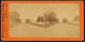
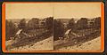
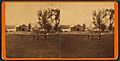
Stereographic cards
Stereoscopic photographs of Solon from the Victorian era:
-
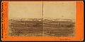
Solon village
-
Main Street
-
Pierce residence
-
Jewett residence
-
Whipple residence
-
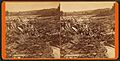
Logs on Caratunk Falls


_L._Pierce,_Solon,_Maine,_from_Robert_N._Dennis_collection_of_stereoscopic_views.jpg)


_Falls,_Solon,_Maine,_from_Robert_N._Dennis_collection_of_stereoscopic_views.jpg)
Sites of interest
Notable people
- George Washburn, pitcher with the New York Yankees (1941)
See also
 In Spanish: Solon (Maine) para niños
