Stark County, Ohio facts for kids
Quick facts for kids
Stark County
|
||
|---|---|---|

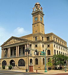
Stark County Courthouse
|
||
|
||

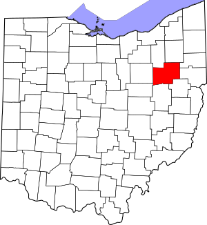
Location within the U.S. state of Ohio
|
||
 Ohio's location within the U.S. |
||
| Country | ||
| State | ||
| Founded | January 1, 1809 | |
| Named for | John Stark | |
| Seat | Canton | |
| Largest city | Canton | |
| Area | ||
| • Total | 581 sq mi (1,500 km2) | |
| • Land | 575 sq mi (1,490 km2) | |
| • Water | 5.3 sq mi (14 km2) 0.9%% | |
| Population
(2020)
|
||
| • Total | 374,853 | |
| • Density | 645.2/sq mi (249.11/km2) | |
| Time zone | UTC−5 (Eastern) | |
| • Summer (DST) | UTC−4 (EDT) | |
| Congressional districts | 7th, 13th, 16th | |
Stark County is a county located in the U.S. state of Ohio. As of the 2020 census, the population was 374,853. Its county seat is Canton. The county was created in 1808 and organized the next year. It is named for John Stark, an officer in the American Revolutionary War.
Stark County is included in the Canton-Massillon, OH Metropolitan Statistical Area, which is also included in the Cleveland-Akron-Canton, OH Combined Statistical Area.
Contents
History
Stark County was named in honor of American Revolutionary War General John Stark. John Stark (August 28, 1728 – May 8, 1822) was a general who served in the American Continental Army during the American Revolutionary War. He became widely known as the "Hero of Bennington" for his exemplary service at the Battle of Bennington in 1777.
During the early 20th century, Stark County was an important location in the early development of professional football. The rivalry between the Massillon Tigers and Canton Bulldogs helped bring the Ohio League to prominence in the mid-1900s (decade) and again in the late 1910s. The Bulldogs ended up a charter member of the National Football League, where it played for several years. (The role Stark County had in developing the game is part of the reason the Pro Football Hall of Fame is located in Canton.) Two relatively large football stadiums, Fawcett Stadium in Canton and Paul Brown Tiger Stadium in Massillon, are still in use (albeit now mostly for high school football), with Fawcett Stadium hosting the NFL's annual Pro Football Hall of Fame Game each year.
In the later 20th century, Stark County's voting record swung from one party to another, closely tracking the winner of the U.S. Presidential election. Even within the swing state of Ohio, Stark County is regarded as a quintessential bellwether, and thus presidential candidates have typically made multiple visits to the region. Major media outlets typically pay close attention to the election results in the county. The New York Times in particular has covered the county's citizens and their voting concerns in a series of features each election cycle for over a decade.
Geography
According to the U.S. Census Bureau, the county has a total area of 581 square miles (1,500 km2), of which 575 square miles (1,490 km2) is land and 5.3 square miles (14 km2) (0.9%) is water.
Adjacent counties
- Portage County (north)
- Mahoning County (northeast)
- Columbiana County (east)
- Carroll County (southeast)
- Tuscarawas County (south)
- Holmes County (southwest)
- Wayne County (west)
- Summit County (northwest)
National protected area
Demographics
| Historical population | |||
|---|---|---|---|
| Census | Pop. | %± | |
| 1810 | 2,734 | — | |
| 1820 | 12,406 | 353.8% | |
| 1830 | 26,588 | 114.3% | |
| 1840 | 34,603 | 30.1% | |
| 1850 | 39,878 | 15.2% | |
| 1860 | 42,978 | 7.8% | |
| 1870 | 52,508 | 22.2% | |
| 1880 | 64,031 | 21.9% | |
| 1890 | 84,170 | 31.5% | |
| 1900 | 94,747 | 12.6% | |
| 1910 | 122,987 | 29.8% | |
| 1920 | 177,218 | 44.1% | |
| 1930 | 221,784 | 25.1% | |
| 1940 | 234,887 | 5.9% | |
| 1950 | 283,194 | 20.6% | |
| 1960 | 340,345 | 20.2% | |
| 1970 | 372,210 | 9.4% | |
| 1980 | 378,823 | 1.8% | |
| 1990 | 367,585 | −3.0% | |
| 2000 | 378,098 | 2.9% | |
| 2010 | 375,586 | −0.7% | |
| 2020 | 374,853 | −0.2% | |
| U.S. decennial census 1790-1960 1900-1990 1990–2000 2020 |
|||
2010 census
As of the 2010 census, there were 375,586 people, 151,089 households, and 100,417 families living in the county. The population density was 652.9 inhabitants per square mile (252.1/km2). There were 165,215 housing units at an average density of 287.2 per square mile (110.9/km2). The racial makeup of the county was 88.7% white, 7.6% black or African American, 0.7% Asian, 0.3% American Indian, 0.5% from other races, and 2.2% from two or more races. Those of Hispanic or Latino origin made up 1.6% of the population. In terms of ancestry, 33.6% were German, 15.5% were Irish, 10.1% were English, 10.1% were Italian, and 7.7% were American.
Of the 151,089 households, 30.2% had children under the age of 18 living with them, 49.2% were married couples living together, 12.7% had a female householder with no husband present, 33.5% were non-families, and 28.1% of all households were made up of individuals. The average household size was 2.42 and the average family size was 2.96. The median age was 41.1 years.
The median income for a household in the county was $44,941 and the median income for a family was $55,976. Males had a median income of $44,238 versus $31,896 for females. The per capita income for the county was $24,015. About 9.5% of families and 12.7% of the population were below the poverty line, including 19.5% of those under age 18 and 6.7% of those age 65 or over.
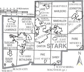
Communities
Cities
- Alliance
- Canal Fulton
- Canton (county seat)
- Louisville
- Massillon
- North Canton
Villages
Townships
- Bethlehem
- Canton
- Jackson
- Lake
- Lawrence
- Lexington
- Marlboro
- Nimishillen
- Osnaburg
- Paris
- Perry
- Pike
- Plain
- Sandy
- Sugar Creek
- Tuscarawas
- Washington
Census-designated places
Other unincorporated communities
Education
Colleges and universities
- Kent State University at Stark
- Malone University
- Stark State College
- University of Mount Union
- Walsh University
Technical/Career centers
- R. G. Drage Career Technical Center
- Sours Adult Career & Technical Center
Public school districts
- Alliance City School District
- Canton City School District
- Canton Local School District
- Fairless Local School District
- Jackson Local School District
- Lake Local School District
- Louisville City School District
- Marlington Local School District
- Massilon City School District
- Minerva Local School District
- North Canton City School District
- Northwest Local School District
- Osnaburg Local School District
- Perry Local School District
- Plain Local School District
- Sandy Valley Local School District
- Tuslaw Local School District
Private school districts
- Stark County Catholic Schools
High schools
- Alliance High School
- Canton McKinley High School
- Canton South High School
- Central Catholic High School
- Early Collage High School
- East Canton High School
- Fairless High School
- GlenOak High School
- Hoover High School
- Indian River High School
- Jackson High School
- Lake Center Christian School
- Lake High School
- Louisville High School
- Marlington High School
- Massillon Christian School
- Minerva High School
- Northwest High School
- Perry High School
- St. Thomas Aquinas High School
- Washington High School
See also
 In Spanish: Condado de Stark (Ohio) para niños


