
State College, Pennsylvania facts for kids
Quick facts for kids
State College, Pennsylvania
Borough of State College
|
|
|---|---|
|
Borough
Home rule municipality |
|
   _near_White_Course_Drive_in_State_College,_Pennsylvania.jpg) Images from top to bottom, left to right (1) Downtown, (2) Campus buildings on Burrowes Rd., (3) Mural on Heister St. Downtown, (4) Campus building spanning across Atherton Street at White Course
|
|
| Nickname(s):
Lion Country, Happy Valley
|
|

Location of State College in Centre County, Pennsylvania.
|
|

State College, Pennsylvania
Location in Pennsylvania

State College, Pennsylvania
Location in the United States
|
|
| Country | United States |
| State | Pennsylvania |
| County | Centre |
| Incorporated | August 29, 1896 |
| Area | |
| • Borough Home rule municipality |
4.56 sq mi (11.80 km2) |
| • Land | 4.56 sq mi (11.80 km2) |
| • Water | 0.00 sq mi (0.00 km2) |
| Elevation | 1,154 ft (352 m) |
| Population
(2010)
|
|
| • Borough Home rule municipality |
42,034 |
| • Estimate
(2019)
|
42,160 |
| • Density | 9,253.73/sq mi (3,572.57/km2) |
| • Urban | 87,454 (US: 335th) |
| • Metro | MSA:158,742 (US: 257th) CSA: 236,577 (US: 124th) |
| Time zone | UTC−5 (EST) |
| • Summer (DST) | UTC−4 (EDT) |
| Zip |
16801, 16802, 16803, 16804, 16805
|
| Area code | 814 and 582 |
| FIPS code | 42-73808 |
| School district | State College Area School District |
State College is a home rule municipality in Centre County in the Commonwealth of Pennsylvania. It is a college town, dominated economically and demographically by the presence of the University Park campus of the Pennsylvania State University (Penn State).
State College is the largest designated borough in Pennsylvania. It is the principal borough of the six municipalities that make up the State College area, the largest settlement in Centre County and one of the principal cities of the greater State College-DuBois Combined Statistical Area with a combined population of 236,577 as of the 2010 United States Census. In the 2010 census, the borough population was 42,034 with approximately 105,000 living in the borough plus the surrounding townships often referred to locally as the "Centre Region." Many of these Centre Region communities also carry a "State College, PA" address although they are not part of the borough of State College. "Happy Valley" and "Lion Country" are other terms used to identify the State College area including the borough as well as the townships of College, Harris, Patton, and Ferguson.
Contents
Economy

Pennsylvania State University is the largest single employer in the region, employing over 27,000 full- and part-time workers in 2016. In addition to higher education, other industries in the area include health care, retail, hospitality services, construction, and government.
| # | Employer | # of employees |
|---|---|---|
| 1 | Pennsylvania State University | 27,029 |
| 2 | Mount Nittany Medical Center | 2,365 |
| 3 | State College Area School District | 1,792 |
| 4 | Government of Pennsylvania | 1,704 |
| 5 | Walmart | 732 |
| 6 | Glenn O. Hawbaker Inc. (construction) | 700 |
| 7 | HRI Inc. (asphalt contractor) | 692 |
| 8 | Weis Markets | 631 |
| 9 | Centre County Government | 586 |
| 10 | Geisinger Medical Group | 563 |
Other notable employers include the Federal Government (452 employees), YMCA (446 employees), Wegmans (430 employees), Shaner Corporation (380 employees), McDonald's (263 employees), Giant Food Stores (255 employees), Hotel State College & Company (251 employees), Raytheon (251 employees), Sheetz (251 employees), Foxdale Village (250 employees), State College Borough Government (213 employees), Minitab (211 employees), and Penn State Hershey Medical Group (200 employees).
Demographics
| Historical population | |||
|---|---|---|---|
| Census | Pop. | %± | |
| 1900 | 851 | — | |
| 1910 | 1,425 | 67.5% | |
| 1920 | 2,405 | 68.8% | |
| 1930 | 4,450 | 85.0% | |
| 1940 | 6,226 | 39.9% | |
| 1950 | 17,227 | 176.7% | |
| 1960 | 22,409 | 30.1% | |
| 1970 | 32,833 | 46.5% | |
| 1980 | 36,130 | 10.0% | |
| 1990 | 38,923 | 7.7% | |
| 2000 | 38,420 | −1.3% | |
| 2010 | 42,034 | 9.4% | |
| 2019 (est.) | 42,160 | 0.3% | |
| Sources: | |||
According to the 2010 census, there were 42,034 people, 12,610 households, and 3,069 families residing in the borough. The population density was 9,258.6 people per square mile (3,574.3/km2). There were 13,007 housing units at an average density of 2,865.0 per square mile (1,106.0/km2). The racial makeup of the borough was 83.2% White, 3.8% Black or African American, 0.2% Native American, 9.8% Asian, 1.0% Other, and 2.0% from two or more races. 3.9% of the population were of Hispanic or Latino ancestry. 22,681 or 54.0% of borough residents were males and 19,353 or 46.0% were females.
A 2014 estimate had the racial makeup of the borough as 78.9% Non-Hispanic White, 5.6% Black or African American, 0.5% Native American and Alaska Native, 11.5% Asian, 0.1% Native Hawaiian and other Pacific Islander, 0.8% Some other race, and 2.2% two or more races. 4.4% were Hispanic or Latino (of any race).
Of the 12,610 households, 9.1% had children under the age of 18 living with them, 18.2% were married couples living together, 3.8% had a female householder with no husband present, 2.4% had a male householder with no wife present, and 75.6% were non-families. 33.6% of all households were made up of individuals, and 5.1% had someone living alone who was 65 years of age or older. The average household size was 2.30 and the average family size was 2.71.
The age distribution of the borough, overwhelmingly influenced by its student population, was 5.1% under the age of 18, 70.6% from 18 to 24, 13.1% from 25 to 44, 6.5% from 45 to 64, and 4.7% who were 65 years of age or older. The median age was 22 years.
The median income for a household in the borough was $23,513, and the median income for a family was $58,953. The per capita income for the borough was $13,336. 46.9% of the population and 9.8% of families were below the poverty line. Out of the total population, 10.6% of those under the age of 18 and 2.2% of those 65 and older were living below the poverty line. However, traditional measures of income and poverty can be very misleading when applied to a community like State College which is dominated by students.
The population of the State College Metropolitan Statistical Area was 153,990 in the 2010 U.S. census.
Sports

State College is most known for Penn State Nittany Lions football which draws over 100,000 fans to Beaver Stadium on home games. The borough itself is home to the State College Spikes, a minor league baseball team. The team is part of the New York–Penn League and has played in Medlar Field at Lubrano Park, also home to Penn State baseball, since 2006.
| Sport | League | Club | Founded | Venue | League championships | Championship years |
|---|---|---|---|---|---|---|
| Baseball | NYPL | State College Spikes | 2006 | Medlar Field at Lubrano Park | 2 | 2014, 2016 |
| Basketball | NCAA | Penn State Nittany Lions Men's Basketball | 1897 | Bryce Jordan Center | 0 | N/A |
| Basketball | NCAA | Penn State Lady Lion's Women's Basketball | 1965 | Bryce Jordan Center | 0 | N/A |
| Football | NCAA | Penn State Nittany Lions football | 1887 | Beaver Stadium | 2 | 1982, 1986 |
| Ice Hockey | NCAA | Penn State Nittany Lions men's ice hockey | 1939 | Pegula Ice Arena | 0 | N/A |
| Ice hockey | NCAA | Penn State Nittany Lions women's ice hockey | 1996 | Pegula Ice Arena | 0 | N/A |
| Soccer | NCAA | Penn State Nittany Lions men's soccer | 1911 | Jeffrey Field | 0 | N/A |
| Soccer | NCAA | Penn State Nittany Lions Women's Soccer | 1994 | Jeffrey Field | 1 | 2015 |
| Volleyball | NCAA | Penn State Nittany Lions men's volleyball | 1976 | Rec Hall | 2 | 1994, 2008 |
| Volleyball | NCAA | Penn State Nittany Lions women's volleyball | 1976 | Rec Hall | 7 | 1999, 2007, 2008, 2009, 2010, 2013, 2014 |
| Wrestling | NCAA | Penn State Nittany Lions Wrestling | 1909 | Rec Hall | 9 | 1921, 1953, 2011, 2012, 2013, 2014, 2016, 2017, 2018, 2019, 2022 |

Jeffrey Field
Jeffrey Field is a soccer specific stadium in State College, Pennsylvania that is home to both the Penn State Nittany Lions women's soccer and Penn State Nittany Lions men's soccer programs. Address is University Drive at East Park Avenue.
Rec Hall
Rec Hall is a field house located on the University Park campus of the Pennsylvania State University. It was opened on January 15, 1929, and is still in use. It is home to the Penn State Nittany Lions women's and men's volleyball teams, and Penn State Nittany Lions wrestling. Rec Hall has a banked indoor track that of approximately 257 yards around or roughly 6.85 laps/mile.
Pegula Ice Arena
The Pegula Ice Arena is a 6,014-seat multi-purpose arena in University Park, Pennsylvania on the campus of Penn State University, opened in October 11, 2013 it replaced the 1,350-seat Penn State Ice Pavilion. The facility is located on the corner of Curtin Road and University Drive near the Bryce Jordan Center.
Beaver Stadium
Beaver Stadium is an outdoor college football stadium in University Park, Pennsylvania, on the campus of Pennsylvania State University. It is home to the Penn State Nittany Lions of the Big Ten Conference since 1960. Beaver Stadium has an official seating capacity of 106,572, making it currently the second largest stadium in the Western Hemisphere and the third largest in the world.
Rothrock State Forest
The Nittany Mountain Biking Association (NMBA) is active at maintaining and adding trails throughout the local state forest. There are miles of trails through Rothrock State Forest most of which are challenging and not for beginners.
Education
Public schools
State College is served by the State College Area School District which operates nine elementary schools, two middle schools, and one high school in and around State College.
Charter schools
- Centre Learning Community Charter School
- Nittany Valley Charter School
- State College Area Delta Program
- Wonderland Charter School
- Young Scholars of Central Pennsylvania Charter School
Private schools
- Children's House Montessori School
- The Goddard School
- Grace Prep High School
- Kinder Station
- Nittany Christian School
- Our Children's Center Montessori School
- Our Lady of Victory Catholic School
- Park Forest Montessori School
- St. John Catholic School
- Saint Joseph's Catholic Academy
- State College Friends School
Higher and post-secondary education
- Penn State University is located partially in the borough of State College.
- South Hills School of Business & Technology
Libraries
State College is served by the following libraries:
- American Philatelic Research Library
- Centre County Library & Historical Museum
- Centre County Library Bookmobile
- Centre Hall Area Branch Library
- Holt Memorial Library (Philipsburg)
- Pennsylvania State University Libraries
- Davey Library (physical and mathematical sciences)
- Deike Library (earth and mineral sciences)
- Hammond Library (engineering)
- Pattee and Paterno Libraries (main library)
- Pollock Library (study library)
- Stuckeman Library (architecture and landscape architecture)
- Schlow Centre Region Library
Infrastructure
Transportation
_in_College_Township,_Pennsylvania.jpg)
State College is located at the junction of Interstate 99/U.S. Route 220 and U.S. Route 322. I-99/US 220 head north to an interchange with Interstate 80 and south towards Altoona. US 322 heads west along with I-99/US 220 and east towards Harrisburg. U.S. Route 322 Business passes east-west through State College on Atherton Street. Pennsylvania Route 26 passes north-south through State College, following the one-way pair of Beaver Avenue northbound and College Avenue southbound. Parking in the downtown area of State College is regulated by on-street parking meters, two off-street parking lots, and four parking garages. The off-street parking lots offer parking with hourly rates while the parking garages offer parking with both hourly rates and monthly permits. Parking in residential areas is regulated by residential parking permits, allowing holders of such permits to park beyond the posted time limits. Some streets near the downtown area allow holders of commuter parking permits to park beyond the posted time limits.
In 2009, the State College metropolitan statistical area (MSA) ranked as the tenth highest in the United States for percentage of commuters who walked to work (8 percent). In 2013, the State College MSA ranked as the fifteenth lowest in the United States for percentage of workers who commuted by private automobile (79.2 percent). During the same year, 9.9 percent of State College area commuters walked to work.
The borough is served by the Centre Area Transportation Authority for local bus service and the University Park Airport for commercial air traffic. Intercity bus service to New York City, Philadelphia, Pittsburgh, and other points across the state is provided by Fullington Trailways, Greyhound Lines, Megabus, and OurBus. The State College Bus Station serving Fullington Trailways and Greyhound Lines is located adjacent to downtown and the Pennsylvania State University campus. Megabus stops in the parking lot of the Walmart along North Atherton Street. State College does not have passenger train service, with the nearest Amtrak stations located in Tyrone (approximately 26 miles away), Huntingdon (approximately 31 miles away) and Lewistown (approximately 32 miles away) serving Amtrak's Pennsylvanian train between Pittsburgh and New York City. Amtrak Thruway Motorcoach service is available via Greyhound Lines from State College to the Harrisburg Transportation Center in Harrisburg, connecting to Amtrak's Keystone Service train to New York City.
Utilities
Electricity in State College is provided by West Penn Power, a subsidiary of FirstEnergy. Natural gas service in the borough is provided by Columbia Gas of Pennsylvania, a division of NiSource. The State College Borough Water Authority provides water service to State College along with Patton, Ferguson, College, Harris, and Benner townships. Sewer service in State College is provided by the University Area Joint Authority. Trash and recycling collection is provided by the borough's Public Works department.
Notable people
The following individuals were born and/or raised in State College:
|
Sport figures:
|
Others:
|
The following were/are residents of State College:
|
Sport figures:
|
Others:
|
Images for kids
-
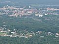
Aerial view of State College
-
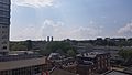
Downtown State College, PA
-
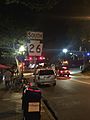
Downtown State College at night
-
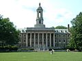
Old Main Building
-
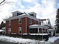
Holmes–Foster–Highlands Historic District
-
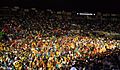
THON 2007 was held for the first time in the Bryce Jordan Center on the University Park campus of Penn State.


See also
 In Spanish: State College (Pensilvania) para niños
