
Tambo, Queensland facts for kids
Quick facts for kids TamboQueensland |
|||||||||||||||
|---|---|---|---|---|---|---|---|---|---|---|---|---|---|---|---|

Arthur Street, Tambo
|
|||||||||||||||

Tambo
Location in Queensland
|
|||||||||||||||
| Population | 367 (2016 census) | ||||||||||||||
| • Density | 0.5939/km2 (1.538/sq mi) | ||||||||||||||
| Established | 1863 | ||||||||||||||
| Postcode(s) | 4478 | ||||||||||||||
| Elevation | 395 m (1,296 ft) | ||||||||||||||
| Area | 617.9 km2 (238.6 sq mi) | ||||||||||||||
| Time zone | AEST (UTC+10:00) | ||||||||||||||
| Location |
|
||||||||||||||
| LGA(s) | Blackall-Tambo Region | ||||||||||||||
| State electorate(s) | Gregory | ||||||||||||||
| Federal Division(s) | Maranoa | ||||||||||||||
|
|||||||||||||||
|
|||||||||||||||
Tambo is a rural town and locality in the Blackall-Tambo Region, Queensland, Australia. In the 2016 census, Tambo had a population of 367 people. Cattle and tourism are the major industries of the town. A number of heritage buildings survive from the earliest days of settlement.
Contents
History
Indigenous
The area on which the town of Tambo now sits was home of many different Aboriginal groups including the Wadjaling, Wadjalad, Wadjabangai, and Pitjara.
European exploration and settlement
The first European exploration of the district was by Sir Thomas Mitchell, popularly known as "Major Mitchell", in 1846. Tambo was originally known as Carrangarra. The settlement was renamed Tambo in 1868. For approximately the next 15 years the area was unused until selectors began taking land in 1861. The town was founded in 1863.
A branch of the Queensland National Bank was first established in 1875.
Tambo was the location of QANTAS's first fatal accident. An Airco DH.9 crashed on 24 March 1927 with the loss of three lives after the plane stalled while landing.
Recent events
Tambo was cut off for eight days during the February 2012 Queensland floods.
Geography and Climate
The Barcoo River runs through the town and sits near the Grey Range – part of the "Roof of Queensland" section of the Great Dividing Range.
The Landsborough Highway—part of the National Highway network linking Brisbane and Darwin—passes through Tambo.
In the 2006 census, Tambo had a population of 345, a small decline from the 2001 census population of 357. Around 7% of the population of Tambo identity as Aboriginal or Torres Strait Islander and around 6% were born outside Australia.
Temperatures in Tambo range from 35 °C in summer to 21 °C in winter. Minimum temperatures in winter often drop below freezing. The average annual rainfall is 535.7 mm (21.0 in), the majority of which falls between December and March.
| Climate data for Tambo (Tambo Post Office 1957–2013) | |||||||||||||
|---|---|---|---|---|---|---|---|---|---|---|---|---|---|
| Month | Jan | Feb | Mar | Apr | May | Jun | Jul | Aug | Sep | Oct | Nov | Dec | Year |
| Record high °C (°F) | 44.2 (111.6) |
42.8 (109.0) |
40.5 (104.9) |
37.1 (98.8) |
34.4 (93.9) |
31.7 (89.1) |
30.0 (86.0) |
35.0 (95.0) |
39.0 (102.2) |
41.0 (105.8) |
43.3 (109.9) |
43.3 (109.9) |
44.2 (111.6) |
| Average high °C (°F) | 34.9 (94.8) |
33.8 (92.8) |
32.4 (90.3) |
29.1 (84.4) |
24.9 (76.8) |
21.6 (70.9) |
21.2 (70.2) |
23.5 (74.3) |
27.3 (81.1) |
30.9 (87.6) |
33.2 (91.8) |
34.8 (94.6) |
29.0 (84.2) |
| Average low °C (°F) | 20.4 (68.7) |
20.0 (68.0) |
17.5 (63.5) |
12.7 (54.9) |
8.1 (46.6) |
4.9 (40.8) |
3.6 (38.5) |
5.1 (41.2) |
9.0 (48.2) |
13.7 (56.7) |
17.0 (62.6) |
19.1 (66.4) |
12.6 (54.7) |
| Record low °C (°F) | 10.4 (50.7) |
9.5 (49.1) |
5.8 (42.4) |
0.0 (32.0) |
−3.0 (26.6) |
−5.0 (23.0) |
−5.6 (21.9) |
−5.6 (21.9) |
−2.5 (27.5) |
−0.5 (31.1) |
4.4 (39.9) |
7.0 (44.6) |
−5.6 (21.9) |
| Average rainfall mm (inches) | 81.0 (3.19) |
77.5 (3.05) |
58.3 (2.30) |
37.1 (1.46) |
34.4 (1.35) |
28.6 (1.13) |
27.1 (1.07) |
18.7 (0.74) |
21.3 (0.84) |
34.6 (1.36) |
47.0 (1.85) |
70.1 (2.76) |
535.7 (21.1) |
| Average rainy days (≥ 0.2mm) | 7.6 | 6.8 | 5.7 | 3.3 | 3.3 | 3.3 | 3.0 | 2.5 | 3.1 | 4.7 | 5.7 | 6.7 | 55.7 |
| Source: Bureau of Meteorology | |||||||||||||
Heritage
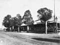
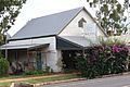
The "Tambo Heritage Trail" includes 17 buildings within the town's precinct of historical importance. They include:
- Post and Telegraph office building
- Reg Barry's Memorial
- Survey Marker
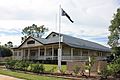
- Old Tambo Post Office (1876)
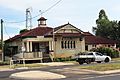
- Courthouse (1888) – now the Public Library
- Tambo Shire Hall
- Masonic Lodge
- Old Powerhouse
- Tambo State School
- Windmill at Tambo Mill Motel
- Primary Health Care
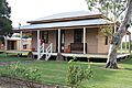
- The Club Hotel
- General Store
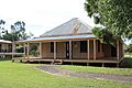
- Royal Carrangarra Hotel
- Tambo Teddies Workshop
- Queensland National Bank
-
Tambo Educational Academy. 1905
-
Volk's Club Hotel, circa 1912
-
The Club Hotel, 2012
-
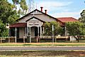
Tambo Public Library, previously Tambo Courthouse. Built in 1888
-
Tambo Post Office, built 1904
-
Tambo Post and Telegraph Office. Built 1876
-
Tambo Electronic Telegraph Office. Built 1885
-
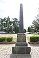
Reg Barry's Memorial
-
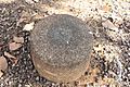
Tambo Survey Marker
-
Tambo Shire Hall
-
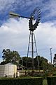
Tambo Windmill
-

Royal Carrangarra Hotel
-
Tambo Teddies Workshop
-
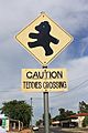
Teddy Crossing Tambo


Heritage listings
Tambo has a number of heritage-listed sites, including:
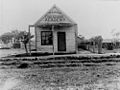
- Arthur Street: former Tambo Post Office
- 9 Arthur Street: former Tambo Court House
Economy
The chief industries of the town and district are grazing properties for sheep and cattle. There was a sawmill (operated by N.K Collins who operated a sawmill in Augathella) which closed in 2011. The sawmill reopened March 2018.
Images for kids
-

Sample of the Tambo Teddies manufactured in Tambo

See also
 In Spanish: Tambo (Queensland) para niños
