Transportation in the Inland Empire facts for kids
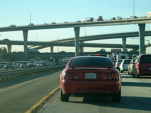
Many of the existing freeways in Southern California's Inland Empire were completed in the late 1970s. The only exception is the segment of the Foothill Freeway, State Route 210 (SR 210) between San Dimas and San Bernardino, completed in July 2007. In general, most of the higher paying jobs are located in Los Angeles and Orange County. Thus, workers must commute daily up to two hours in each direction on the existing network. As the population increases, traffic congestion is projected to increase as well. In 2007, Forbes magazine ranked the area first in its list of America's most unhealthy commutes, beating every other major metropolitan area in the country, as Inland area drivers breathe the unhealthiest air and have the highest rate of fatal auto accidents per capita.
Freeway system
The Inland Empire is crossed by two interstates as well as several major state highways. Although the major building for them was finished years ago (with exception of recent completion of SR 210 from Fontana to San Bernardino), growth in the region has strained the freeways system. As a result, several major projects have recently been completed or are underway on freeways throughout the region. Examples include the 60/215/91 interchange and widening of I-10 through Redlands as well as the currently ongoing widening of I-215 through downtown San Bernardino into the city's University District.
 State Route 2
 San Bernardino Freeway (Interstate 10)
 Mojave Freeway/Barstow Freeway/Ontario Freeway/Corona Freeway/Temecula Valley Freeway/Escondido Freeway (Interstate 15)
 State Route 18
 State Route 38
 Needles Freeway (Interstate 40)
 State Route 58
 Pomona Freeway/Moreno Valley Freeway (State Route 60)
 State Route 62
 State Route 66
 Corona Expressway/Chino Valley Freeway (State Route 71)
 State Route 74
 State Route 78
 State Route 79
 State Route 83
 State Route 86
 State Route 86S
 Riverside Freeway (State Route 91)
 U.S. Route 95
 State Route 111
 State Route 127
 State Route 138
 State Route 142
 State Route 173
 State Route 177
 State Route 178
 State Route 189
 State Route 195
 Foothill Freeway (State Route 210)
 Barstow Freeway/San Bernardino Freeway/Riverside Freeway/Moreno Valley Freeway/Escondido Freeway (Interstate 215)
 State Route 243
 State Route 247
 State Route 259
 State Route 330
 State Route 371
 U.S. Route 395
 County Route R2
 County Route R3
Public transportation
 |
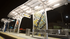 |
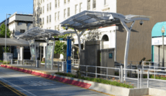
| Downtown San Bernardino's Civic Center Station on the rapid transit sbX's Green Line. This station is the northernmost downtown station located on Court Street, near Court Street Square and the Entertainment District's Theatre Square. | Downtown San Bernardino's Hunts Lane Station on the rapid transit sbX's Green Line. The station is the southernmost downtown station located on Hunts Lane, near the San Bernardino Hall of Records. |
- Metrolink commuter rail provides service to points throughout the Greater Los Angeles Area, San Diego and the rest of Southern California.
- San Bernardino Express, a brt system that is currently the only rapid transit system in the Inland Empire. Serves San Bernardino and Loma Linda.
- Morongo Basin Transit Authority provides bus service to and from Morongo Basin communities, Palm Springs, Yucca Valley and Twentynine Palms.
- Omnitrans is the largest public transportation provider in San Bernardino County.
- Riverside Transit Agency is the largest public transportation provider in Riverside County.


