
Upper Montclair, New Jersey facts for kids
Quick facts for kids
Upper Montclair, New Jersey
|
|
|---|---|
.jpg)
Upper Montclair business district
|
|
| Nickname(s):
Up-town
|
|

Location in Essex County and the state of New Jersey.
|
|

Upper Montclair, New Jersey
Location in Essex County, New Jersey
|
|
| Country | |
| State | |
| County | Essex |
| Township | Montclair |
| Area | |
| • Total | 2.536 sq mi (6.569 km2) |
| • Land | 2.535 sq mi (6.567 km2) |
| • Water | 0.001 sq mi (0.002 km2) 0.04% |
| Elevation | 322 ft (98 m) |
| Population | |
| • Total | 11,565 |
| • Density | 1,699.9/sq mi (656.3/km2) |
| Time zone | UTC-5 (Eastern (EST)) |
| • Summer (DST) | UTC-4 (EDT) |
| ZIP codes |
07043
|
| Area code(s) | 862/973 |
| FIPS code | 3475020 |
| GNIS feature ID | 2584034 |
| Website | http://www.montclairnjusa.org/ |
Upper Montclair is a census-designated place (CDP), unincorporated community and neighborhood within Montclair in Essex County, New Jersey, United States. As of the 2010 United States Census, the population for the CDP was 11,565. The area is served as United States Postal Service ZIP code 07043. It is often misperceived, even by Montclair residents, to be a separate municipality from Montclair, perhaps aided by this postal designation.
Contents
History
The area now known as Upper Montclair was first developed in the early 18th century as a rural community known as Speertown, named for John Speer, an early Dutch settler. The area remained a rural hamlet for much of that century. The modern township of Montclair, including Upper Montclair, was incorporated in 1868 from part of Bloomfield Township.
Geography
 |
Little Falls Township | Clifton | Clifton | |
| Cedar Grove | Bloomfield Township | |||
| Verona | Remainder of Montclair | Glen Ridge |
According to the United States Census Bureau, the CDP had a total area of 2.536 square miles (6.569 km2), including 2.535 square miles (6.567 km2) of land and 0.001 square miles (0.002 km2) of water (0.04%).
Upper Montclair is north of Watchung Avenue, covering 40.2% of Montclair township's area.
Demographics
As of the census of 2010, there were 11,565 people, 4,178 households, and 3,146 families residing in the CDP. The population density was 4,561.4 per square mile (1,761.2/km2). There were 4,310 housing units at an average density of 1,699.9 per square mile (656.3/km2)*. The racial makeup of the CDP was 83.99% (9,713) White, 6.46% (747) Black or African American, 0.10% (12) Native American, 4.18% (483) Asian, 0.00% (0) Pacific Islander, 1.31% (151) from other races, and 3.97% (459) from two or more races. [[Hispanic (U.S. Census)|Hispanic or Latino of any race were 5.61% (649) of the population.
There were 4,178 households out of which 44.2% had children under the age of 18 living with them, 64.8% were married couples living together, 7.9% had a female householder with no husband present, and 24.7% were non-families. 20.3% of all households were made up of individuals, and 8.3% had someone living alone who was 65 years of age or older. The average household size was 2.76 and the average family size was 3.23.
In the CDP, the population was spread out with 29.9% under the age of 18, 4.3% from 18 to 24, 20.8% from 25 to 44, 33.7% from 45 to 64, and 11.3% who were 65 years of age or older. The median age was 42.1 years. For every 100 females there were 90.2 males. For every 100 females ages 18 and old there were 85.7 males.
Transportation
Upper Montclair is well connected to the rest of New Jersey and New York City on account of its transportation infrastructure. Public transportation options in Upper Montclair are buses and trains, both provided by New Jersey Transit, although commuter bus service to Manhattan is provided by DeCamp Bus Lines.
Rail

New Jersey Transit's Montclair-Boonton Line Runs through the neighborhood of Upper Montclair. In total in Upper Montclair there are a total of three train stations of the overall Montclair total of seven. This is because the stations in Montclair are very close together, sometimes under a mile apart. New Jersey Transit train stations are Upper Montclair, Mountain Avenue, and Montclair Heights. From 1889 to 1928, Valley Road, a major road, had an electric trolley line.
Bus

The area is also on NJ Transit's bus route 28, which goes from Montclair State University or Willowbrook Mall along Valley Road through Montclair, Glen Ridge and Bloomfield, to Downtown Newark. This bus route goes along Valley road for the great majority of its path in Upper Montclair, in some places on the route of Decamp's Number 66. Also, two DeCamp Bus Lines routes take commuters to the Port Authority Bus Terminal in New York. Some Number 33 buses go along Grove Street, on the Eastern side of the neighborhood, while number 66 goes on Valley Road, in the West, then the central Park Street.
Road
Upper Montclair has road connections to the rest of Montclair, Cedar Grove, Little Falls, Clifton, and Bloomfield. Just north of the neighborhood's border are U.S. Route 46 and New Jersey Route 3.
Parks
Upper Montclair is home to many parks and nature reserves. Within Upper Montclair there are Anderson Park, Yantacaw Brook Park, the Bonsal Nature Reserve, Mountainside Park, the Presby Memorial Iris Gardens, and parts of Mills Reservation and Brookdale Park. In addition, Upper Montclair has the Mountainside Public Pool, which is the largest of the three public pools in Montclair.
Upper Montclair also has Immaculate Conception Cemetery and Mount Hebron Cemetery.
Gallery
- Upper Montclair Gallery
-
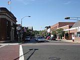
Business district in Upper Montclair, which is around the intersection of Valley Road and Bellevue Avenue
-
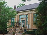
Upper Montclair's library, which is called the Bellevue Branch
-
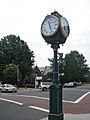
A landmark in Upper Montclair, a clock owned by Chase bank that is situated in the center of town and was installed around 1910. About 2004, the clock was sent away for needed refurbishment.
-
A movie being filmed in Upper Montclair
-

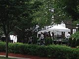
the Montclair Women's Club


Education
.jpg)
Upper Montclair is in the township of Montclair and is served by the Montclair Public Schools. More than a quarter of the district's schools are found in Upper Montclair. These include Bradford Elementary and Northeast Elementary, which are two of seven elementary schools in Montclair, and Mt. Hebron Middle School, renamed Buzz Aldrin Middle School in September 2016 in honor of the astronaut, who grew up in Montclair, which is one of three Montclair middle schools. Part of Montclair State University's campus is in Upper Montclair.
Upper Montclair is also home to several private schools. They include Lacordaire Academy, Lacordaire Academy Elementary Division and St. Cassian School.
Notable people
People who were born in, residents of, or otherwise closely associated with Upper Montclair include:


- Buzz Aldrin (born 1930), astronaut who was the second man to walk on the Moon.
- Yael Averbuch (born 1986), soccer player.
- Raymond A. Brown (1915–2009), attorney whose clients included Black Liberation Army member Assata Shakur, boxer Rubin "Hurricane" Carter and "Dr. X" physician Mario Jascalevich.
- Margaret Colin (born 1958), actress.
- Justin Deas (born 1948), actor.
- John Langley Howard (1902–1999), muralist, printmaker and illustrator, known for his social realism.
- Howard Krongard, head of the Office of the Inspector General of the Department of State.
- Rosemary Rice (1925–2012), actress best known for her role as Katrin on CBS-TV series Mama.
- Joe Walsh (born 1947), singer, songwriter, composer, multi-instrumentalist and record producer.
- Ingrid Wells (born 1989), soccer player.
Images for kids
-
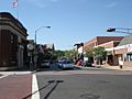
Business district in Upper Montclair, which is around the intersection of Valley Road and Bellevue Avenue
-
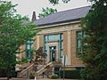
Upper Montclair's library, which is called the Bellevue Branch
-
A landmark in Upper Montclair, a clock owned by Chase bank that is situated in the center of town and was installed around 1910. About 2004, the clock was sent away for needed refurbishment.
-
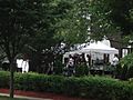
A movie being filmed in Upper Montclair
-
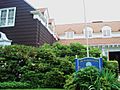
the Montclair Women's Club
.jpg)
.jpg)

.jpg)
See also
 In Spanish: Upper Montclair (Nueva Jersey) para niños
