Little Falls, New Jersey facts for kids
Quick facts for kids
Little Falls, New Jersey
|
|
|---|---|
|
Township
|
|
| Township of Little Falls | |

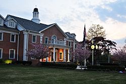
Little Falls Town Hall
|
|

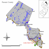
Map of Little Falls Township in Passaic County. Inset: Location of Passaic County highlighted in the State of New Jersey.
|
|

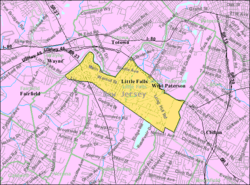
Census Bureau map of Little Falls, New Jersey
|
|
| Country | |
| State | |
| County | |
| Incorporated | April 2, 1868 |
| Government | |
| • Type | Faulkner Act (mayor–council) |
| • Body | Township Council |
| Area | |
| • Total | 2.87 sq mi (7.43 km2) |
| • Land | 2.80 sq mi (7.24 km2) |
| • Water | 0.07 sq mi (0.19 km2) 2.54% |
| Area rank | 345th of 565 in state 14th of 16 in county |
| Elevation | 157 ft (48 m) |
| Population | |
| • Total | 13,360 |
| • Rank | 193rd of 565 in state 8th of 16 in county |
| • Density | 4,655/sq mi (1,798.1/km2) |
| • Density rank | 103rd of 566 in state 7th of 16 in county |
| Time zone | UTC−05:00 (Eastern (EST)) |
| • Summer (DST) | UTC−04:00 (Eastern (EDT)) |
| ZIP Code |
07424
|
| Area code(s) | 973 |
| FIPS code | 3403140620 |
| GNIS feature ID | 0882313 |
Little Falls is a township in Passaic County, New Jersey, United States. The township was named for a waterfall on the Passaic River at a dam near Beattie Mill.
As of the 2020 census, the township's population was 13,360 reflecting a decrease of 1,072 (7.4%) from the 14,432 counted in the 2010 Census, which had in turn increased by 3,577 (33.0%) from the 10,855 counted in the 2000 Census.
Contents
History
Little Falls traces its first settlement to 1711 when seven Bergen Dutch settlers banded together to begin farming. The Speer Homestead dates from circa 1785 (and may have originally been built in 1680).
The Morris Canal, once an important artery of trade and transportation until 1925 between the Delaware and Hudson rivers, wound its way through the township and vestiges of it still remain., some parts of which are a greenway.
Little Falls was incorporated as a township by an act of the New Jersey Legislature on April 2, 1868, from portions of Acquackanonk Township. On March 25, 1914, portions of the township were taken to form the borough of West Paterson (now Woodland Park).
Geography
According to the United States Census Bureau, the township had a total area of 2.810 square miles (7.277 km2), including 2.735 square miles (7.084 km2) of land and 0.075 square miles (0.193 km2) of water (2.65%).
Singac (with a 2010 Census population of 3,618) is an unincorporated community and census-designated place (CDP) located within Little Falls Township.
The township has three main sub-divisions. Great Notch is the easternmost part of Little Falls. The downtown area is frequently referred to as "The Center of Town", mainly by longtime residents, and is usually referred to as simply Little Falls. Singac is in the westernmost portion of the township. Much of Singac borders the Passaic River.
Little Falls is bordered by the municipalities of Clifton, Totowa, Wayne, Woodland Park in Passaic County; and Cedar Grove, Fairfield and Montclair, North Caldwell in Essex County. It is located about 15 miles (24 km) west of New York City.
Demographics
| Historical population | |||
|---|---|---|---|
| Census | Pop. | %± | |
| 1870 | 1,282 | — | |
| 1880 | 1,404 | 9.5% | |
| 1890 | 1,890 | 34.6% | |
| 1900 | 2,908 | 53.9% | |
| 1910 | 3,750 | 29.0% | |
| 1920 | 5,161 | 37.6% | |
| 1930 | 5,161 | 0.0% | |
| 1940 | 5,368 | 4.0% | |
| 1950 | 6,405 | 19.3% | |
| 1960 | 9,730 | 51.9% | |
| 1970 | 11,727 | 20.5% | |
| 1980 | 11,496 | −2.0% | |
| 1990 | 11,294 | −1.8% | |
| 2000 | 10,855 | −3.9% | |
| 2010 | 14,432 | 33.0% | |
| 2020 | 13,360 | −7.4% | |
| Population sources: 1870-1920 1870 1880-1890 1890-1910 1910-1930 1930-1990 2000 2010 * = Lost territory in previous decade. 2020 |
|||
Census 2010
As of the census of 2010, there were 14,432 people, 4,740 households, and 2,825 families residing in the township. The population density was 5,276.2 per square mile (2,037.2/km2). There were 4,925 housing units at an average density of 1,800.5 per square mile (695.2/km2)*. The racial makeup of the township was 86.68% (12,510) White, 4.11% (593) Black or African American, 0.15% (22) Native American, 4.56% (658) Asian, 0.01% (1) Pacific Islander, 2.38% (344) from other races, and 2.11% (304) from two or more races. [[Hispanic (U.S. Census)|Hispanic or Latino of any race were 9.89% (1,428) of the population.
There were 4,740 households out of which 22.8% had children under the age of 18 living with them, 45.8% were married couples living together, 10.2% had a female householder with no husband present, and 40.4% were non-families. 33.1% of all households were made up of individuals, and 12.6% had someone living alone who was 65 years of age or older. The average household size was 2.36 and the average family size was 3.04.
In the township, the population was spread out with 13.7% under the age of 18, 29.4% from 18 to 24, 21.0% from 25 to 44, 22.8% from 45 to 64, and 13.0% who were 65 years of age or older. The median age was 32.1 years. For every 100 females there were 81.9 males. For every 100 females ages 18 and old there were 78.2 males.
The Census Bureau's 2006-2010 American Community Survey showed that (in 2010 inflation-adjusted dollars) median household income was $78,318 (with a margin of error of +/- $8,244) and the median family income was $92,462 (+/- $12,925). Males had a median income of $67,585 (+/- $7,860) versus $42,270 (+/- $3,385) for females. The per capita income for the borough was $34,505 (+/- $3,336). About 4.7% of families and 6.0% of the population were below the poverty line, including 8.1% of those under age 18 and 10.2% of those age 65 or over.
Same-sex couples headed 42 households in 2010, an increase from the 33 counted in 2000.
Census 2000
As of the 2000 United States Census there were 10,855 people, 4,687 households, and 2,873 families residing in the township. The population density was 3,941.8 people per square mile (1,524.1/km2). There were 4,797 housing units at an average density of 1,742.0 per square mile (673.5/km2). The racial makeup of the township was 92.13% white, 0.65% African American, 0.06% Native American, 4.20% Asian, 0.02% Pacific Islander, 1.33% from other races, and 1.60% from two or more races. Hispanic or Latino of any race were 5.33% of the population.
There were 4,687 households, out of which 22.9% had children under the age of 18 living with them, 49.1% were married couples living together, 9.4% had a female householder with no husband present, and 38.7% were non-families. 33.1% of all households were made up of individuals, and 13.3% had someone living alone who was 65 years of age or older. The average household size was 2.32 and the average family size was 2.99.
In the township, the population was spread out, with 18.1% under the age of 18, 6.6% from 18 to 24, 32.4% from 25 to 44, 24.9% from 45 to 64, and 17.9% who were 65 years of age or older. The median age was 41 years. For every 100 females, there were 89.7 males. For every 100 females age 18 and over, there were 87.4 males.
The median income for a household in the township was $58,857, and the median income for a family was $70,223. Males had a median income of $49,136 versus $37,727 for females. The per capita income for the township was $33,242. About 2.8% of families and 4.6% of the population were below the poverty line, including 4.8% of those under age 18 and 4.9% of those age 65 or over.
Transportation
Roads and highways
As of May 2010[update], the township had a total of 37.65 miles (60.59 km) of roadways, of which 24.55 miles (39.51 km) were maintained by the municipality, 10.87 miles (17.49 km) by Passaic County and 2.23 miles (3.59 km) by the New Jersey Department of Transportation.
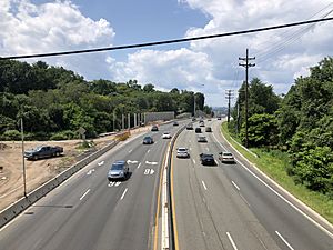
Little Falls is crisscrossed by several major roadways, including U.S. Route 46 and New Jersey Route 23. The Garden State Parkway and Interstate 80 run near the municipality. There are numerous crossings of the Upper Passaic River in town.
Public transportation
The Little Falls station and Montclair State University station of NJ Transit both serve Little Falls, offering service on the Montclair-Boonton Line to Hoboken Terminal in Hoboken, or from Montclair State University Station on Midtown Direct trains to New York City's Pennsylvania Station in Midtown Manhattan via the Secaucus Junction. The township was formerly served by the Great Notch station until NJ Transit closed it in January 2010 because of low ridership.
NJ Transit bus transportation is offered to the Port Authority Bus Terminal in Midtown Manhattan on the 191, 194 and 195 routes. Newark, New Jersey, is served by routes 11 and 28 (on Saturdays and Sundays). Local routes are the 704 and 705 lines. In September 2012, as part of budget cuts, NJ Transit suspended service to Newark on the 75 line.
Little Falls is approximately 21 miles (34 km) from Newark Liberty International Airport and approximately 27 miles (43 km) from LaGuardia Airport in Flushing, Queens, New York.
In popular culture
- A delicatessen on Main Street in Little Falls was featured in the episode "House Arrest" from the second season of television series The Sopranos.
- The township was well known for the Colonial Inn, a hotel and lounge where comedian Jackie Gleason performed stand-up in the 1930s.
Sports
The New Jersey Jackals of the Frontier League play at Yogi Berra Stadium, located in Little Falls on the campus of Montclair State University.
Education
For public school, students in pre-kindergarten through eighth grade are educated by the Little Falls Township Public Schools. As of the 2018–19 school year, the district, comprised of three schools, had an enrollment of 865 students and 94.6 classroom teachers (on an FTE basis), for a student–teacher ratio of 9.1:1. Schools in the district (with 2018–19 enrollment data from the National Center for Education Statistics) are Little Falls School #2 with 301 students in grades PreK-2, Little Falls School #3 with 184 students in grades 3-4 and Little Falls School #1 with 376 students in grades 5–8.
For ninth through twelfth grades, students in public school attend Passaic Valley Regional High School, which also serves students from Totowa and Woodland Park. The school facility is located in Little Falls. As of the 2018–19 school year, the high school had an enrollment of 1,186 students and 102.0 classroom teachers (on an FTE basis), for a student–teacher ratio of 11.6:1. Seats on the high school district's nine-member board of education are allocated based on the population of the constituent municipalities, with three seats each assigned Little Falls, Totowa and Woodland Park.
Most of Montclair State University is located in Little Falls. During 2011, the university employed 66 residents on a full or part-time basis, who earned almost $3.5 million in total compensation.
Notable people
People who were born in, residents of, or otherwise closely associated with Little Falls include:
- David Blaine (born 1973), illusionist.
- Frank DeCaro (born 1962), author and television personality.
- Bobby Marks (born 1972/73), former National Basketball Association assistant general manager of the Brooklyn Nets.
- Lloyd B. Marsh (1893–1971), politician who served as Secretary of State of New Jersey and Chairman of the New Jersey Republican State Committee.
- Kit McClure (born 1951), saxophonist, trombonist and bandleader.
- Leonard Schoonmaker (1882–1950), fencer who competed in the individual foil and épée events at the 1920 Summer Olympics.
- Franklin E. Sigler (1924–1995), U.S. Marine who was the recipient of the congressional Medal of Honor for his actions during the Battle of Iwo Jima.
- Grif Teller (1899–1993), artist known for his paintings for the Pennsylvania Railroad.
- Lois Utz (1932–1986), children's author.
- Vikki Ziegler (born c. 1972), lawyer and author who was the focus of the reality television show Untying the Knot.
See also
 In Spanish: Little Falls (Nueva Jersey) para niños


