Walton County, Georgia facts for kids
Quick facts for kids
Walton County
|
|
|---|---|

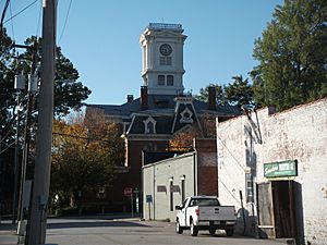
Walton County courthouse in Monroe
|
|

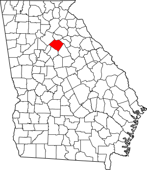
Location within the U.S. state of Georgia
|
|
 Georgia's location within the U.S. |
|
| Country | |
| State | |
| Founded | December 22, 1818 |
| Named for | George Walton |
| Seat | Monroe |
| Largest city | Monroe |
| Area | |
| • Total | 330 sq mi (900 km2) |
| • Land | 326 sq mi (840 km2) |
| • Water | 4.3 sq mi (11 km2) 1.3%% |
| Population | |
| • Estimate
(2018)
|
93,503 |
| • Density | 257/sq mi (99/km2) |
| Time zone | UTC−5 (Eastern) |
| • Summer (DST) | UTC−4 (EDT) |
| Congressional district | 10th |
Walton County is a county located in the north central portion of the U.S. state of Georgia. As of the 2010 census, the population was 83,768. It is located about 30 miles east of the state capital, the city of Atlanta. Monroe is the county seat; Loganville is another major city.
Walton County is part of the Atlanta-Sandy Springs-Roswell, GA Metropolitan Statistical Area.
Contents
History
Walton County was created on December 15, 1818. It is named for George Walton, one of the three men from Georgia who signed the United States Declaration of Independence. The other two were Button Gwinnett and Lyman Hall.
Walton County is located about 30 miles east of the city of Atlanta. Monroe is the county seat, with other major towns being Loganville and other communities.
Walton County has been home to,the birthplace of, or claim to seven Georgia governors (in chronological order): Wilson Lumpkin, Howell Cobb, Alfred Colquitt, James Boynton, Henry McDaniel, Clifford Walker, and Richard Russell, Jr..
Geography
According to the U.S. Census Bureau, the county has a total area of 330 square miles (850 km2), of which 326 square miles (840 km2) is land and 4.3 square miles (11 km2) (1.3%) is water.
The western half of Walton County, in a half circle from Social Circle through Monroe to northeast of Loganville, is located in the Upper Ocmulgee River sub-basin of the Altamaha River basin. The eastern part of the county, east of that curve, is located in the Upper Oconee River sub-basin of the same Altamaha River basin.
Major highways
Adjacent counties
- Barrow County – north
- Oconee County – northeast
- Morgan County – southeast
- Newton County – south
- Rockdale County – southwest
- Gwinnett County – northwest
Demographics
There was a noted decline in population from 1900 to 1960, as thousands of African Americans left the rural area in the Great Migration, moving to the North, Midwest and West Coast to escape social oppression and to gain better jobs and opportunities.
With dramatic new growth related to the rise of Atlanta as a corporate city, the demographics have changed and the county is majority white in the 21st century. The area has been developed for suburban housing and retail.
| Historical population | |||
|---|---|---|---|
| Census | Pop. | %± | |
| 1810 | 1,026 | — | |
| 1820 | 4,192 | 308.6% | |
| 1830 | 10,929 | 160.7% | |
| 1840 | 10,209 | −6.6% | |
| 1850 | 10,821 | 6.0% | |
| 1860 | 11,074 | 2.3% | |
| 1870 | 11,038 | −0.3% | |
| 1880 | 15,622 | 41.5% | |
| 1890 | 17,467 | 11.8% | |
| 1900 | 20,942 | 19.9% | |
| 1910 | 25,393 | 21.3% | |
| 1920 | 24,216 | −4.6% | |
| 1930 | 21,118 | −12.8% | |
| 1940 | 20,777 | −1.6% | |
| 1950 | 20,230 | −2.6% | |
| 1960 | 20,481 | 1.2% | |
| 1970 | 23,404 | 14.3% | |
| 1980 | 31,211 | 33.4% | |
| 1990 | 38,586 | 23.6% | |
| 2000 | 60,687 | 57.3% | |
| 2010 | 83,768 | 38.0% | |
| 2018 (est.) | 93,503 | 11.6% | |
| U.S. Decennial Census 1790-1960 1900-1990 1990-2000 2010-2013 |
|||
2010 census
As of the 2010 United States Census, there were 83,768 people, 29,583 households, and 22,921 families living in the county. The population density was 257.2 inhabitants per square mile (99.3/km2). There were 32,435 housing units at an average density of 99.6 per square mile (38.5/km2). The racial makeup of the county was 80.1% white, 15.6% black or African American, 1.1% Asian, 0.3% American Indian, 0.1% Pacific islander, 1.4% from other races, and 1.5% from two or more races. Those of Hispanic or Latino origin made up 3.2% of the population. In terms of ancestry, 20.2% identified as American, 15.6% as African-American, 12.2% as Irish, 10.9% as English, and 8.9% as German.
Of the 29,583 households, 40.7% had children under the age of 18 living with them, 58.5% were married couples living together, 13.9% had a female householder with no husband present, 22.5% were non-families, and 18.7% of all households were made up of individuals. The average household size was 2.81 and the average family size was 3.19. The median age was 37.4 years.
The median income for a household in the county was $51,721 and the median income for a family was $58,750. Males had a median income of $45,669 versus $32,064 for females. The per capita income for the county was $22,521. About 10.5% of families and 12.5% of the population were below the poverty line, including 17.6% of those under age 18 and 9.1% of those age 65 or over.
2020 census
| Race | Num. | Perc. |
|---|---|---|
| White (non-Hispanic) | 68,499 | 70.86% |
| Black or African American (non-Hispanic) | 17,136 | 17.73% |
| Native American | 188 | 0.19% |
| Asian | 1,409 | 1.46% |
| Pacific Islander | 44 | 0.05% |
| Other/Mixed | 4,169 | 4.31% |
| Hispanic or Latino | 5,228 | 5.41% |
As of the 2020 United States census, there were 96,673 people, 33,350 households, and 25,736 families residing in the county.
Communities
Cities
Towns
Unincorporated communities
- Bold Springs
- Campton
- Gratis
- Mt. Vernon
- Pannell
- Windsor
- Youth
Transportation
Major highways
Walton County doesn't have any pedestrian trails. However, there are trails in neighboring Gwinnett and Rockdale county such as the Arabia Mountain Path, Conyers Trail and Cedar Creek Trail Loop.
See also
 In Spanish: Condado de Walton (Georgia) para niños

