
Wright Patman Lake facts for kids
Quick facts for kids Wright Patman Lake |
|
|---|---|

Wright Patman Lake
Location in Texas

Wright Patman Lake
Location in the United States
|
|

Map
|
|
| Location | Bowie / Cass counties, Texas, United States |
| Coordinates | 33°18′17″N 94°09′36″W / 33.30472°N 94.16000°W |
| Type | Flood control reservoir |
| Primary inflows | Sulphur River |
| Primary outflows | Sulphur River |
| Basin countries | United States |
| Surface area | 20,300 acres (8,200 ha) |
| Max. depth | 34.6 ft (10.5 m) |
| Water volume | 158,000 acre⋅ft (0.195 km3) |
| Surface elevation | 220.6 ft (67.2 m) |

Wright Patman Lake is a reservoir in northeast Texas in the United States. The lake is a U.S. Army Corps of Engineers reservoir formed on the Sulphur River in Bowie and Cass counties by Wright Patman Dam. The reservoir provides flood control and water conservation for the communities downstream from the dam. The lake is also a popular recreational destination. The Bowie County side of the lake is part of the Texarkana metropolitan area.
Contents
Geography
Wright Patman Lake is located at 33°16′48″N 94°18′00″W / 33.28000°N 94.30000°W. It is located on the border between Bowie County and Cass County, Texas, and the geographic center is about 18 miles (29 km) southwest of Texarkana, Texas and 148 miles (238 km) east of Dallas. Towns in the immediate vicinity of the lake include Redwater, Maud, and Douglassville, Texas.
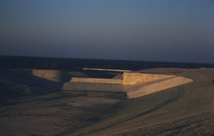
The lake is formed by water impounded by Wright Patman Dam. The water is mainly from the Sulphur River, but several smaller creeks also flow into the lake. The lake's conservation pool level is 220.6 feet (67.2 m) above sea level, and the spillway level is at 259.5 feet (79.1 m) above sea level.
History
Wright Patman Lake and Dam were authorized as part of the United States' Flood Contract Act of 1946. Originally known as Texarkana Reservoir, the lake was later renamed to Lake Texarkana. Construction of the dam began in 1948, and the lake was formed when water was impounded in 1953. In 1973, the lake and dam were renamed in honor of Congressman Wright Patman of Texas.


Flood protection
Wright Patman Lake provides flood protection for areas downstream along the Sulphur River and Red River. In the 38.9 feet (11.9 m) between its conservation pool and spillway levels, the lake can hold 2,406,000 acre-feet (2.968×10⁹ m3) of flood water.


Recreation
The U.S. Army Corps of Engineers maintains nine parks around Wright Patman Lake. These parks provide lake access for boating, swimming, and fishing; as well as camping, picnicking, hiking, equestrian trails, and other outdoor activities. Atlanta State Park is also located on the south shore of the lake.
- Wright Patman Lake from the Handbook of Texas Online
