
Amambay facts for kids
Quick facts for kids
Amambay
|
|||
|---|---|---|---|

International border on Av. Dr. Francia
|
|||
|
|||

Location of Amambay, in red, in Paraguay
|
|||
| Country | |||
| Region | Oriental | ||
| Capital | Pedro Juan Caballero | ||
| Boroughs | Pedro Juan Caballero, Capitán Matías Bado, Bella Vista Norte, Zanja Pyta, Karapa`i | ||
| Area
(2012) |
|||
| • Total | 12,933 km2 (4,993 sq mi) | ||
| Population
(2012)
|
|||
| • Total | 125,611 | ||
| • Density | 9.7124/km2 (25.1551/sq mi) | ||
| Demonym(s) | Amambayense | ||
| Time zone | UTC-04 (AST) | ||
| • Summer (DST) | UTC-03 (ADT) | ||
| ISO 3166 code | PY-13 | ||
| Website | Official website: http://amambay.gov.py/ | ||


The Amambay department (Spanish: Departamento de Amambay) is a department of Paraguay. The capital is the city of Pedro Juan Caballero. Its ISO 3166-2 code is PY-13.
The name comes from the name of a part of the Caaguazú Cordillera, the "Amambay Cordillera" (Spanish: Cordillera de Amambay). Amambay (or amambái) means "fern" in Guaraní language; ferns are common in the forests of the region.
History
The town of Pedro Juan Caballero was found in 1893, and Bella Vista, in 1902. The department of Amambay was created in 1945 as the No. 10 department of the country. After some reorganization it was declared as the No. 13 department.,
Pedro Juan Caballero, the capital of the department, is still known by its old name, Punta Porá, because is near the Punta Porá Hill; that name was used by the people that transported yerba mate from Mato Grosso to Concepción. The BrazilIan municipality across the border, Ponta Porã (Mato Grosso do Sul), keeps the name.
Geography
The Amambay department is in the north part of the Oriental region. It has an area of 12,933 km2 (4,993 sq mi), with a population of 125,611 for a Population density of 9.7.
Amambay is the highest of the Paraguayan departments, 300–400 m (984–1,312 ft) high, and the Punta Porá Hill, 700 m (2,297 ft) high, is one the highest point in the country.
Limits
- To the north: Brazil, separated by the Apa river and the Amambay Cordillera.
- To the east: Brazil, separated by the Amambay Cordillera.
- To the south: Canindeyú department.
- To the west: Concepción and San Pedro departments.
 |
Brazil | |
||
| Concepción | Brazil | |||
| San Pedro | Canindeyú |
Rivers
The main rivers in the department are the Apa in the north, and the Ypané and the Aquidabán rivers in the central part of the department.
Climate
As of 2012[update], the total amount of precipitation for the year 2012 in the city of Pedro Juan Caballero was 1,800.7 mm (70.9 in). The month with the most precipitation was February with 253.6 mm (10.0 in) of precipitation. The month with the least precipitation was May with 2.1 mm (0.1 in).
The average temperature for the year 2012 in Pedro Juan Caballero was 22.5 °C (72.5 °F). The warmest month, on average, was December with an average temperature of 31.8 °C (89.2 °F). The coolest month on average is July, with an average temperature of 17.1 °C (62.8 °F).
Districts
The department is divided in 5 districts:
| Districts | Area (km²) |
Population (2015) |
Density |
|---|---|---|---|
| Bella Vista | 3,926 | 15,537 | 4.0 |
| Capitán Bado | 3,276 | 18,712 | 5.7 |
| Pedro Juan Caballero | 2,678 | 113,872 | 42.5 |
| Zanja Pytá | 2,106 | 7,362 | 3.5 |
| Karapaí | 1,274 | 3,780 | 3.0 |
Related pages
Images for kids
-
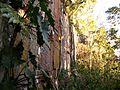
Cerro Muralla, "Wall Hill", in Amambay in the Cerro Corá National Park
-
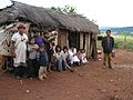
Pai Tavytera people in Amambay, 2012


See also
 In Spanish: Departamento de Amambay para niños
