
Blackford County, Indiana facts for kids
Quick facts for kids
Blackford County
|
|
|---|---|

Blackford County Courthouse in Hartford City
|
|

Location within the U.S. state of Indiana
|
|
 Indiana's location within the U.S. |
|
| Country | |
| State | |
| Founded | April 2, 1838 |
| Named for | Isaac Blackford |
| Seat | Hartford City |
| Largest city | Hartford City |
| Area | |
| • Total | 165.58 sq mi (428.9 km2) |
| • Land | 165.08 sq mi (427.6 km2) |
| • Water | 0.50 sq mi (1.3 km2) 0.30%% |
| Population | |
| • Estimate
(2018)
|
11,930 |
| • Density | 77/sq mi (29.86/km2) |
| Time zone | UTC−5 (Eastern) |
| • Summer (DST) | UTC−4 (EDT) |
| Congressional districts | 3rd, 5th |
| Indiana county number 5 FIPS Code 009 |
|
Blackford County is located in the east central portion of the U.S. state of Indiana. The county is named for Judge Isaac Blackford, who was the first speaker of the Indiana General Assembly and a long-time chief justice of the Indiana Supreme Court. Created in 1838, Blackford County is divided into four townships, and its county seat is Hartford City. Two incorporated cities and one incorporated town are located within the county. The county is also the site of numerous unincorporated communities and ghost towns. Occupying only 165.58 square miles (428.9 km2), Blackford County is the fourth smallest county in Indiana. As of the 2010 census, the county's population was 12,766 people in 5,236 households. Based on population, the county is the 8th smallest county of the 92 in Indiana. Although no interstate highways are located in Blackford County, three Indiana state roads cross the county, and an additional state road is located along the county's southeast border. The county has two railroad lines. A north–south route crosses the county, and intersects with a second railroad line that connects Hartford City with communities to the west.
Before the arrival of European-American settlers during the 1830s, the northeastern portion of the future Blackford County was briefly the site of an Indian reservation for Chief Francois Godfroy of the Miami tribe. The first European-American pioneers were typically farmers who settled on arable land near rivers. Originally, the county was mostly swampland, but more land became available for farming as the marshes were cleared and drained. Over the next 30 years, small communities developed throughout the county. When the county's rail lines were constructed in the 1860s and 1870s, additional communities evolved around railroad stops.
Beginning in the late 1880s, the discovery of natural gas and crude oil in the county (and surrounding region) caused the area to undergo an economic boom period known as the Indiana Gas Boom. Manufacturers relocated to the area to take advantage of the low-cost energy and railroad facilities. The boom period lasted about 15 years, and is reflected in Blackford County's population, which peaked in 1900 at 17,213. The construction associated with the additional prosperity of the boom period caused a significant upgrade in the county's appearance, as wooden buildings were replaced with masonry structures. Much of the infrastructure built during that time remains today—including Montpelier's historic Carnegie Library and many of Hartford City's buildings in the Courthouse Square Historic District.
Agriculture continues to be important to the county, and became even more important after the loss of several large manufacturers during the 20th century. Today, 72 percent of Blackford County is covered by either corn or soybean fields; additional crops, such as wheat and hay, are also grown.
Contents
Geography
According to the 2010 census, Blackford County has a total area of 165.58 square miles (428.9 km2), of which 165.08 square miles (427.6 km2) (or 99.70%) is land and 0.50 square miles (1.3 km2) (or 0.30%) is water, making it the fourth smallest county in the state. The county is located in East Central Indiana, about 55 miles (89 km) south of Fort Wayne, Indiana, and about 78 miles (126 km) northeast of Indianapolis. Along the north side of the county is Wells County, and on the eastern side of the county is Jay County, which separates Blackford County from Indiana's border with the state of Ohio. Delaware County is located on Blackford County's southern border, and to the west is Grant County.
The county land was flattened by two glaciers millions of years ago. These glaciers are also responsible for the rich Blackford County farmland that became available after the county was cleared and drained. During the early 20th century, the Renner Stock Farm, in Licking Township, was known statewide for its quality cattle, hogs, and horses.{{ The county has some small streams and lakes, although the lakes are man-made. The Salamonie River, flowing out of Jay County (Indiana) from the east, crosses the northeast corner of Blackford County. Big and Little Lick Creek flow westward in Licking and Jackson townships in the southern half of the county. Early settlers were attracted to Lick Creek, and then the Salamonie River, because the nearby land had suitable drainage for farming. The county's lakes include Lake Blue Water in Harrison Township; Cain's Lake, Shamrock Lakes and Lake Mohee in Licking Township; and Lake Placid in Jackson Township. Lake Blue Water is a spring-fed former stone quarry located one mile (1.6 km) east of Montpelier. The Shamrock Lakes (a group of six lakes) were created between 1960 and 1965, and the first lake was originally intended to be a water supply for a farmer's cattle.
Licking and Harrison townships were original to the county. Washington Township, which is named after President George Washington, was created June 29, 1839, by the county commissioners. Jackson Township, which is thought to be named after President Andrew Jackson, was created by the commissioners on September 22, 1839.
Communities
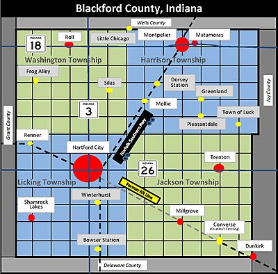
Two incorporated cities are located within the county, and a small portion of a third city occupies the county's southeast corner. The largest city is county seat Hartford City, located in the southern half of the county. Hartford City's population in 2010 was 6,220—well below its 1970 peak of 8,207. Another incorporated city is Montpelier, which is located on the southern banks of the Salamonie River in the northeastern part of the county. Montpelier's 2010 population was 1,805, which is below its Census Bureau peak of 3,405 achieved in 1900—and less than one half of an unofficial peak of 5,000 estimated during the city's oil boom in 1895. A small portion of the city of Dunkirk, known as Shadyside, is located in the Jackson Township portion of Blackford County, but most of Dunkirk is located in Jay County. The population for the entire city of Dunkirk was 2,362 in 2010. Shamrock Lakes is Blackford County's only incorporated town, achieving that status on May 21, 1973—and was the first community in Indiana to do so in 50 years. Its 2010 population was 231.
Road maps typically show five unincorporated communities in Blackford County: Converse (formerly named Crumley's Crossing), Matamoras, Millgrove, Roll (formerly named Dundee), and Trenton (former post office named Priam). These communities are sometimes listed as ghost towns, as nearly all businesses in these communities have closed. However, residences are still maintained in these communities, and they are listed as populated places by the U.S. Geological Survey. Millgrove, Roll, and Trenton all had post offices during the 19th or 20th centuries.
Extinct settlements
Blackford County has over 10 communities that do not exist anymore. In some cases, a church, farm or single residence remains at the extinct community's location. Among these former communities, Bowser Station, Dorsey Station, Mollie, Silas, and Slocum all had post offices during the 19th century. Mollie's post office lasted until 1907.
- Bowser Station—This community was a railroad stop in southern Licking Township, and had a post office during the 1870s.
- Dorsey Station—This Harrison Township community was a railroad stop, and had a post office during the 1870s.
- Frog Alley—This Washington Township community had a church and school. The name Frog Alley was bestowed on the community because of the swampy condition of the area. The school, which began in 1863, lasted until 1923.
- Greenland—Located in Harrison Township at 400 North and 600 East.
- Little Chicago—Located in northwest corner of Harrison Township, and in Wells County.
- Mollie—This community thrived in the 1890s as a railroad stop with a grain elevator, post office, and general store. The Harrison Township oil fields were located nearby.
- Pleasantdale—Located in Harrison Township, at 300 North and 600 East.
- Renner—This Licking Township community was a railroad stop next to the Renner Stock Farm. Housing for the farm's employees was also located there. It thrived from the 1890s until the 1920s. Renner is still listed as a populated place by the U.S. Geological Survey, but its "population" is a farm.
- Silas—The Washington Township land that became the community of Silas was purchased in 1848, and the original owner established a church and school. By 1880, a general store was established at that location, and its owner was community namesake Silas Rayl. During the first decade of the 20th century, the Silas general store closed, contributing to the demise of the community.
- Slocum—This community was located in southeastern Harrison Township (exact location not known), and had a post office from 1886 until 1902.
- The Town of Luck—Located in Harrison Township at 250 North and 800 East.
- Winterhurst—Located in Licking Township, at 200 South and 0.5 miles (0.80 km) East.
History


Following thousands of years of varying cultures of indigenous peoples, the historic Miami and Delaware Indians (a.k.a. Lenape) are the first-recorded permanent settlers in the Blackford County area, living on the Godfroy Reserve after an 1818 treaty. The site is located in Blackford County's Harrison Township, east of Montpelier. Although the Godfroy Reserve was allotted to Miami Indian Chief Francois (a.k.a. Francis) Godfroy, Delaware Indians were also allowed to stay there. The Miami tribe was the most powerful group of Indians in the region, and Francois Godfroy (who was half French) was one of their chiefs. By 1839, Godfroy had sold the reserve, and the Indians had migrated west. Benjamin Reasoner was the first European–American to enter future Blackford County, and its first land owner. He entered what would become Licking Township on July 9, 1831. Reasoner and his sons built the county's first mill, which was located on the family farm.
For a brief period, the land that would become Blackford County was the western part of Jay County. An act of the Indiana General Assembly, which was approved January 30, 1836, created Jay County effective after March 1, 1836. In December 1836, a motion was made in the Indiana House of Representatives to review dividing Jay County, but that resolution was not adopted. Two Blackford County communities, Matamoras and Montpelier, originally existed as part of Jay County. Both of these communities are located along the Salamonie River in what became the northeast portion of Blackford County. John Blount founded Matamoras, arriving in 1833. This village is Blackford County's oldest community, and is the site of the county's largest water mill. The mill, constructed around 1843, was considered one of the finest in the state. Blackford County's other former Jay County community is Montpelier, which is located west of Matamoras on the Salamonie River. Led by Abel Baldwin, the community was started in 1836 by groups of migrant settlers from Vermont. The Vermont natives named the settlement after the capital of their home state, Montpelier. Blackford County's Montpelier was platted in 1837 (before Matamoras), and is the county's oldest platted community.
Several sources claim Blackford County was created in 1837. However, the law was not finalized until 1838. Indiana bill of the House No. 152 was originally for the creation of a county named Windsor. The name "Windsor" was replaced with the name "Blackford" by the House of Representatives in January 1838. An "act for the formation of the county of Blackford" was approved on February 15, 1838. This act intended that the county would be "open for business" on the first Monday in April, 1838, which was April 2. However, the county was not organized. Finally, on January 29, 1839, the original February 15 act was amended, stating that Blackford County shall "enjoy the rights and privileges" of an independent county. The act also appointed commissioners, and corrected a misprint that defined the southeast corner of the new county.
Over the next two years, a political "battle" continued over the location of the county seat. The tiny community of Hartford was repeatedly selected by the commissioners, but those decisions were challenged by individuals favoring Montpelier. While Licking Township (location of community of Hartford) was the most populous township in the county, the community of Montpelier was the county's oldest platted community. After a third and fourth act of the Indiana General Assembly, Hartford was finalized as the location of the county seat—and construction of a courthouse began. Because it was discovered that another community in Indiana was also named Hartford, Blackford County's Hartford was eventually renamed Hartford City.
During the next 25 years, the county grew slowly. Plans were made for roads and railroads, and swampland was drained. The first railroad line was authorized in 1849. The plan was for the Fort Wayne & Southern Railroad Company to connect the Indiana cities of Fort Wayne and Muncie—running north–south through the Blackford County communities of Montpelier and Hartford City. Although work constructing the railroad line began in the 1850s, it was not completed (by connecting Fort Wayne to Muncie) until 1870, and this delay caused it to be the second railroad to operate in Blackford County. By the time the railroad began operations, it was named Fort Wayne, Cincinnati & Louisville Railroad. The Lake Erie and Western Railroad acquired this railroad in 1890.
The first railroad to operate in Blackford County crossed somewhat east–west through the county's southern half. The railroad was named Union and Logansport Railroad Company by the time it entered Blackford County. This line was proposed in 1862, and completed to Hartford City in 1867—running through the Blackford County communities of Dunkirk, Crumley's Crossing, and Hartford City. The small community of Crumley's Crossing was renamed Converse, and two other communities (Millgrove and Renner) became established on this line. The railroad was eventually named Pittsburgh, Cincinnati and St. Louis Railroad. Other names for the railroad since that time include the Panhandle division of the Pennsylvania Railroad, Penn Central Railroad Company, Conrail, and Norfolk Southern Railway. A portion of this line is now abandoned, and the track has been removed between Converse and Hartford City, south of State Road 26.
Gas boom

In 1886, natural gas was discovered in two counties adjacent to Blackford County. The discoveries were in the small community of Eaton (south of Hartford City along railroad line) in Delaware County, and in the city of Portland in Jay County (east of Hartford City and Millgrove). The Hartford City Gas & Oil Company was formed in early 1887, and successfully drilled a natural gas well later in the year. In Montpelier, the Montpelier Gas & Oil Mining company was organized in the spring of 1887. While natural gas was found throughout Blackford County, crude oil was found mostly in the county's Harrison Township (somewhat between Montpelier and Mollie). Blackford County's first successful oil well, located just south of Montpelier, began producing during 1890. Montpelier was thought to be "the very heart of the greatest natural gas and oil field in the world". Oil was also found in parts of Washington Township, including a well that was thought to be "the most phenomenal well ever drilled in America". By 1896, Blackford County had 18 natural gas companies. These companies were headquartered in all four of the county's townships, including the communities of Hartford City, Montpelier, Roll, Dunkirk, Trenton (Priam Post Office), and Millgrove.
In June 1880, only 171 people held manufacturing jobs in Blackford County. The Indiana Gas Boom transformed the region, as manufacturers moved to the area to utilize the natural gas and railroad system. During 1901, Indiana state inspectors visited 21 manufacturing facilities in Blackford County, and these companies employed 1,346 people (compare to 171 two decades earlier). Since these inspections were in Hartford City and Montpelier only, additional manufacturing employees from the county's small communities (such as Millgrove's glass factory) could be added to the count of 1,346. The county's two largest employers were glass factories: American Window Glass plant number 3 and Sneath Glass Company. Hartford City's resources (low cost energy, two railroads, and workforce) were especially favored by glass factories, and a 1904 directory lists 10 of them.
In addition to an economic transformation, another byproduct of the gas boom was an upgrade of Blackford County's appearance. Many of the county's landmark buildings were constructed during the gas boom, including the current courthouse and surrounding buildings in Hartford City's Courthouse Square Historic District. The city's waterworks was also built during that period. Additional buildings include the Carnegie Library and historic Presbyterian Church. In Montpelier, many of the buildings in its Downtown Historic District were also constructed during the gas boom. Montpelier's historic Baptist Church and Montpelier's Carnegie Library were constructed in the early 1900s – near the end of the gas boom.
Post-gas boom


The Indiana Gas Boom gradually came to an end during the first decade of the 20th century. The end of the gas boom meant less prosperity for the county. The gas and oil workers left, some of the manufacturers moved, and the service industries were forced to close or cut back operations because of fewer customers. Adding to the county's problems, machines made the labor–intensive method originally used for producing window glass obsolete, causing many of the county's skilled glass workers at the large American Window Glass plant to lose their jobs. By 1932, the window glass plant of the county's former largest employer was closed. According to the United States Census, Blackford County's population peaked at 17,123 in 1900, and it still has not returned to that zenith over 100 years later.
The end of the gas boom was especially difficult for the smaller communities in the county, since the loss of a single business had more of an impact on undersized communities than it did for a town with many businesses. In the case of Millgrove, the community's major manufacturer (a glass factory) closed. For other communities, such as Mollie, the loss of the gas and oil workers meant that the local post office was a "waste of time", and consumer demand at the general store was significantly diminished.
Improvements to the automobile and highways, which coincided with the end of the gas boom, may have also contributed to the decline of the county's smaller communities. The automobile changed "business and shopping patterns at the expense of the small-town merchant." Small town residents began to drive to larger communities to purchase goods, because of the wider selection. The improved quality of automobiles and roads competed with passenger service on the railroads (and interurban lines), causing a decline in passenger traffic on the rails. Small towns associated with railroad stations suffered from the loss in traffic. In Blackford County, passenger service on the Lake Erie and Western Railroad line (owned by the Nickel Plate Road by that time) was discontinued in 1931, and the last interurban train ran on January 18, 1941.
Although the natural gas and oil workers left the area after the gas (and oil) boom, Montpelier's population eventually stabilized—and Hartford City's grew. Some of the manufacturers remained in the county's two largest cities because of a lack of better alternatives. Hartford City's Sneath Glass Company, a major employer, continued operations until the 1950s. Hartford City leaders attracted businesses such as [[Garage door opener|group=Note}} The county lost another major Hartford City employer in 2011 when the Key Plastics plant closed, as 200 people lost their jobs.
Agriculture continues to be an important factor in the county's economy. Over 70 percent of Blackford County's land is occupied by soybean or corn fields. Additional crops and livestock are also raised. Good returns in agriculture are not always reflected in the economy of nearby towns, as industrial agriculture has reduced the number of workers it needs, and family farms have declined. Many small towns in the "Corn Belt", such as the communities in Blackford County, continue to decline in size and affluence.
Demographics
| Historical population | |||
|---|---|---|---|
| Census | Pop. | %± | |
| 1840 | 1,226 | — | |
| 1850 | 2,860 | 133.3% | |
| 1860 | 4,122 | 44.1% | |
| 1870 | 6,272 | 52.2% | |
| 1880 | 8,020 | 27.9% | |
| 1890 | 10,461 | 30.4% | |
| 1900 | 17,213 | 64.5% | |
| 1910 | 15,820 | −8.1% | |
| 1920 | 14,084 | −11.0% | |
| 1930 | 13,617 | −3.3% | |
| 1940 | 13,783 | 1.2% | |
| 1950 | 14,026 | 1.8% | |
| 1960 | 14,792 | 5.5% | |
| 1970 | 15,888 | 7.4% | |
| 1980 | 15,570 | −2.0% | |
| 1990 | 14,067 | −9.7% | |
| 2000 | 14,048 | −0.1% | |
| 2010 | 12,766 | −9.1% | |
| 2018 (est.) | 11,930 | −6.5% | |
| U.S. Decennial Census 1790-1960 1900-1990 1990-2000 2010-2013 |
|||
As of the 2010 United States Census, Blackford County's population density was 77.3 inhabitants per square mile (29.8/km2), well below the average for Indiana, which was 180.8 inhabitants per square mile (69.8/km2). Blackford County had 12,766 people, 5,236 households, and 3,567 families residing within its borders. The racial makeup of the county was 97.7 percent white, 0.4 percent black or African American, 0.2 percent Native American, 0.1 percent Asian, 0.3 percent from other races, and 1.3 percent from two or more races. Those of Hispanic or Latino origin made up 0.9 percent of the population.
The average household size was 2.41, and the average family size was 2.88. Families accounted for 68.1 percent of the county's 5,236 households, and 75.5 percent of these families included a husband and wife living together. Children under the age of 18 were living in 38.9 percent of the family households. Non-family households accounted for 31.9 percent of total households, and 86.8 percent of them were occupied by someone living alone. People 65 years and older, living alone, accounted for 40.1 percent of non-family households—or 12.8 percent of all types of households.
In terms of age distribution, 22.8 percent of the population were under the age of 18, and 21.6 percent were 62 years of age or older. The median age was 42.4 years. For every 100 females, there were 97.2 males. For every 100 females age 18 and over, there were 93.7 males.
As of the 2000 United States Census, the median income for a household in the county was $34,760, and the median income for a family was $41,758. Males had a median income of $30,172 versus $21,386 for females. The per capita income for the county was $16,543. About 6.0 percent of families and 8.7 percent of the population were below the poverty line, including 12.3 percent of those under age 18 and 8.6 percent of those age 65 or over. In terms of ancestry, 16.7 percent were German, 15.5 percent were American, 9.3 percent were Irish and 7.8 percent were English.
Climate and weather
| Weather chart for Hartford City, Indiana | |||||||||||||||||||||||||||||||||||||||||||||||
|---|---|---|---|---|---|---|---|---|---|---|---|---|---|---|---|---|---|---|---|---|---|---|---|---|---|---|---|---|---|---|---|---|---|---|---|---|---|---|---|---|---|---|---|---|---|---|---|
| J | F | M | A | M | J | J | A | S | O | N | D | ||||||||||||||||||||||||||||||||||||
|
2
33
18
|
1.9
38
22
|
2.8
49
31
|
3.4
62
41
|
3.8
72
50
|
4.3
81
60
|
4.3
84
63
|
4.1
82
62
|
2.9
76
54
|
2.5
65
43
|
3.4
50
34
|
2.7
38
23
|
||||||||||||||||||||||||||||||||||||
| temperatures in °F precipitation totals in inches source: The Weather Channel |
|||||||||||||||||||||||||||||||||||||||||||||||
|
Metric conversion
|
|||||||||||||||||||||||||||||||||||||||||||||||
Blackford County has a typical Midwestern humid continental seasonal climate, and its Köppen climate classification is Dfa. There are four distinct seasons, with winters being cold with moderate snowfall, while summers can be warm and humid. In recent years, average temperatures in county seat Hartford City have ranged from a low of 18 °F (−8 °C) in January to a high of 84 °F (29 °C) in July, although a record low of −26 °F (−32 °C) was recorded in January 1994 and a record high of 103 °F (39 °C) was recorded in June 1988. Average monthly precipitation ranged from 1.94 inches (49 mm) in February to 4.33 inches (110 mm) in June.
March and April are considered tornado season in Indiana. Blackford County endured a category 4 storm on Palm Sunday (April 11) in 1965. This storm was one of many tornados that occurred in the Midwest on that day. Category 4 tornados have maximum speeds of 207 to 260 miles per hour (333 to 418 km/h), and this one crossed Blackford County farmland east of Roll. Although there were no fatalities in Blackford County from this tornado, two people were killed in neighboring Wells County. The county has experienced at least five other tornados. The most recent tornados were two that occurred in Hartford City in 2002. However, the two Hartford City tornados were rated category 1 on the Fujita scale—much less dangerous than a category 4.
Blackford County has a record for hail. Hail 4.5 inches (110 mm) in diameter fell in Hartford City on April 9, 2001. In a tie with the city of Cayuga, those hail "stones" are the largest ever recorded in the state of Indiana.
The biggest recorded snow storm was the Great Blizzard of 1978, which occurred on January 26–27, 1978. A federal state of emergency was declared for Indiana at that time. Indiana governor Otis R. Bowen authorized the use of National Guard equipment, facilities, and personnel throughout the state. Low temperatures, high winds, and deep snow caused Hartford City to look like a ghost town, as schools and businesses closed. Wind gusts up to 45 miles per hour (72 km/h) caused snowdrifts up to 5 feet (1.5 m) high, making travel by any type of truck or automobile almost impossible. Snowmobiles were the only viable means of transportation, and volunteers from Hartford City's Snowmobile Club provided emergency assistance.
Transportation

There are no interstate highways in Blackford County, although Interstate 69 passes near the county's western border.
State Road 3 enters the county from Delaware County on the south. It runs north through Hartford City and enters Wells County near Roll. State Road 18 runs west–east through the north end of the county, on its way from Marion to the Ohio border; it passes through Montpelier and Matamoras.
State Road 26 also runs from west to east, entering from Upland in Grant County and crossing Hartford City at State Road 3. It continues through Trenton to Jay County.
State Road 167 runs along the eastern border of the county for about 5 miles (8.0 km) as it goes north from Dunkirk; it terminates when it reaches State Road 26.
A Norfolk Southern Railway railroad line enters the county from the south after leaving Eaton; it runs about a mile to the east of State Road 3 until it reaches Hartford City where it veers to the northeast and passes through Montpelier. It continues into Wells County to the north. Norfolk Southern also owns Blackford County's east–west line in southern Blackford county. An 8-mile (13 km) section of this line, between Converse and Hartford City, was abandoned during the last decade, and track has been removed. The line is still in service north of State Road 26, between Hartford City and Upland in Grant County. In October 2009, Central Railroad Company of Indianapolis pursued a leasing agreement to operate the east–west line with Norfolk Southern Railway in Blackford County. However, the line currently does not appear on the Central Railroad Company of Indianapolis system map.
Economy

Blackford County's economy is supported by a labor force of approximately 5,900 workers with an unemployment rate for June 2013 of 9.8 percent. There are industrial parks in Montpelier and Hartford City, and both cities are served by railroad line owned by Norfolk Southern. Over 30 employers of varying size are located in the county. The Blackford County School System has the most employees, with locations in both Hartford City and Montpelier. 3M Company is currently the largest manufacturer in the county, and has been located in Hartford City since its purchase of the Hartford City Paper Mill in 1955. Another business employing more than 100 people is Blackford County Community Hospital, located in Hartford City. Emhart Gripco is Montpelier's leading employer, with over 100 employees.
Four categories account for over half the county's employment: manufacturing, government, retail trade, and health care. The largest category is manufacturing, with about 19 percent of the county's workforce. In addition to local Blackford County businesses, larger local economies in the more populous counties to the south and west offer employment and commerce, particularly in the city of Muncie in Delaware County, and the city of Marion in Grant County. Both counties employ more workers than their local workforce can provide. Agriculture has a significant impact on the county, although farm workers account for only about 5 percent of the county's workers. In 2007, the county had 250 farms occupying 84,626 acres (34,247 ha), so four-fifths of Blackford County is farmland. Nearly 72,000 acres (29,000 ha) are devoted to soybeans and corn. Wheat, hay, and oats are also grown. Livestock include over 24,000 hogs and pigs.
Notable people

Astronaut Kevin A. Ford lived in Montpelier, Indiana, for several years and graduated from Blackford High School in 1978. He was born in Portland, Indiana, in 1960. Holding four academic degrees, Ford retired from active duty as a colonel in the United States Air Force in 2008. He was the pilot for the Space Shuttle Discovery during its August 2009 flight, and has logged over 332 hours in outer space. On October 23, 2012, Ford returned to the International Space Station aboard a Russian spacecraft.
Radio DJ Larry Monroe was born in Hartford City, Indiana, on August 29, 1942. He graduated from Hartford City High School in 1960. From 1981 until his death in 2014 he was one of the most popular radio personalities in Austin, Texas. His shows are rebroadcast every Monday evening on KDRP-LP.
Clarence G. Johnson, who lived in Hartford City from 1923 until he died in 1935, was the first president of Overhead Door Corporation. He was a pioneer in the development of garage doors, and holds numerous patents. One of Johnson's more notable inventions is the first "electric operator for sectional upward-acting doors". Johnson's Overhead Door Corporation was a major employer in Blackford County for over 60 years, employing as many as 515 people during its peak years.
Former Indiana governor Maurice Clifford Townsend was born August 11, 1884, in Blackford County's Licking Township. After graduating from college in Marion, Indiana, Townsend served as superintendent of Blackford County schools, superintendent of Grant County schools, and as a representative of the Blackford-Grant District in the Indiana General Assembly. He was elected as Indiana's lieutenant governor in 1932. He won the 1936 election for governor, and served the single four-year term allowed by law. After his service in his home state, Townsend worked in the federal administration of President Franklin D. Roosevelt, in agriculture–related assignments. One memorable achievement: he directed school buses be painted yellow for safety and identification purposes, an idea that spread nationwide.
Golfer Erika Wicoff, a native of Hartford City, is one of the most decorated female athletes in Indiana University history, earning three Big Ten Player of the Year awards. She was the Big Ten women's golf champion in 1994, 1995 and 1996. She later competed in the Ladies Professional Golf Association. Wicoff was inducted into the Indiana Athletics Hall of Fame in 2006.
See also
 In Spanish: Condado de Blackford para niños
