
California State Route 99 facts for kids
Quick facts for kids
|
||||
|---|---|---|---|---|
| Golden State Highway | ||||
| Lua error in Module:Infobox_road/map at line 15: attempt to index field 'wikibase' (a nil value). | ||||
| Route information | ||||
| Defined by S&HC § 399 | ||||
| Maintained by Caltrans | ||||
| Length | 424.85 mi (683.73 km)
(includes unsigned overlap with US 50 and I-5)
|
|||
| Existed | 1928 as US 99, 1964 as SR 99–present | |||
| Major junctions | ||||
| South end | ||||
| North end | ||||
| Highway system | ||||
| State highways in California(list • pre-1964) History • Unconstructed • Deleted • Freeway • Scenic
|
||||

State Route 99 (commonly known as Old Highway 99 or just 99, also named in the future as Interstate 7 or Interstate 9) is a state highway in California, in the United States. It is about 424.85 miles (683.73 km) long, running from north to south in the Central Valley. It is parallel with Interstate 5. It begins at Interstate 5 near Wheeler Ridge, and continues north through the major cities of Bakersfield, Fresno, Chowchilla, Modesto, Stockon, Sacramento, Chico, and Red Bluff. Most of it is freeway, but some of it is still the historic rural two-lane road or a four-lane highway.
Images for kids
-
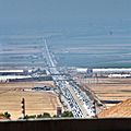
SR-99's southern terminus, and the Wheeler Ridge Interchange, viewed looking north from I-5 in the Tejon Pass.
-
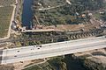
SR 99 crossing the San Joaquin River at the northern border of Fresno with the early stages of construction of California High-Speed Rail's San Joaquin River Viaduct, as well as the existing Union Pacific Railroad bridge, also visible
-
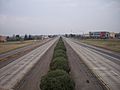
Facing north from Skyway on SR 99 in Chico with the Butte College, Chico Campus visible on the right


See also
 In Spanish: Ruta Estatal de California 99 para niños
