
Griggstown, New Jersey facts for kids
Quick facts for kids
Griggstown, New Jersey
|
|
|---|---|

Griggstown Reformed Church
|
|

Griggstown, New Jersey
Location in Somerset County, New Jersey

Griggstown, New Jersey
Location in New Jersey

Griggstown, New Jersey
Location in the United States
|
|
| Country | |
| State | |
| County | Somerset |
| Township | Franklin |
| Named for | Griggs family |
| Area | |
| • Total | 2.519 sq mi (6.524 km2) |
| • Land | 2.447 sq mi (6.338 km2) |
| • Water | 0.072 sq mi (0.187 km2) 2.86% |
| Elevation | 102 ft (31 m) |
| Population | |
| • Total | 819 |
| • Density | 334.7/sq mi (129.2/km2) |
| Time zone | UTC-5 (Eastern (EST)) |
| • Summer (DST) | UTC-4 (Eastern (EDT)) |
| Area code(s) | 609/640, 732/848 and 908 |
| FIPS code | 3428470 |
| GNIS feature ID | 2583995 |
Griggstown is an unincorporated community and census-designated place (CDP) located within Franklin Township, in Somerset County, New Jersey, United States. As of the 2010 United States Census, the CDP's population was 819. The area was first settled around 1733.
Contents
History
Many of the earliest European settlers of the area came from Gravesend, Brooklyn. Among these settlers were four sons born to John and Elizabeth Griggs: Benjamin (b. 1690), Daniel, Samuel, and Thomas. Griggstown was named after Benjamin Griggs, who established a grist mill on the Millstone River that served as a meeting place for the European farmers of the area and as such the center of the community that would become Griggstown.
Geography
According to the United States Census Bureau, the CDP had a total area of 2.519 square miles (6.524 km2), including 2.447 square miles (6.338 km2) of land and 0.072 square miles (0.187 km2) of water (2.86%).
Griggstown is adjacent to the communities of Kingston, Rocky Hill, Montgomery Township, Kendall Park (in South Brunswick Township), and Franklin Park. The closest city of note is Princeton, New Jersey. The Millstone River and the Delaware and Raritan Canal both flow through Griggstown.
Griggstown is accessible via Route 27 (Lincoln Highway), County Route 518 and U.S. Route 206. The major roads in Griggstown are Bunker Hill Road and Canal Road. There is also a small access road with a one-lane bridge(at one time referred to as "twin bridges") known as the Griggstown Causeway that offers access to and from Griggstown as well. The D&R Canal State Park is located on this road in conjunction with the canal side tow-path.
Selected sites
- Reformed Church of Griggstown
- Griggstown Quail Farm
- Griggstown Cemetery where nineteen Irish canal workers who died of cholera in an 1832-1833 epidemic are buried.
- Griggstown Volunteer Fire Company
- Griggstown Lock of the Delaware and Raritan Canal
- Griggstown Mine
- Norseville
- Sunset Hill Garden
Demographics
| Historical population | |||
|---|---|---|---|
| Census | Pop. | %± | |
| 2010 | 819 | — | |
| Population sources: 2010 | |||
Census 2010
As of the census of 2010, there were 819 people, 346 households, and 230 families residing in the CDP. The population density was 334.7 per square mile (129.2/km2). There were 364 housing units at an average density of 148.8 per square mile (57.5/km2)*. The racial makeup of the CDP was 86.81% (711) White, 2.81% (23) Black or African American, 0.24% (2) Native American, 4.03% (33) Asian, 0.00% (0) Pacific Islander, 2.56% (21) from other races, and 3.54% (29) from two or more races. [[Hispanic (U.S. Census)|Hispanic or Latino of any race were 6.23% (51) of the population.
There were 346 households out of which 25.7% had children under the age of 18 living with them, 57.2% were married couples living together, 6.6% had a female householder with no husband present, and 33.5% were non-families. 27.2% of all households were made up of individuals, and 11.6% had someone living alone who was 65 years of age or older. The average household size was 2.36 and the average family size was 2.92.
In the CDP, the population was spread out with 18.1% under the age of 18, 4.6% from 18 to 24, 27.5% from 25 to 44, 32.4% from 45 to 64, and 17.5% who were 65 years of age or older. The median age was 44.9 years. For every 100 females there were 101.7 males. For every 100 females ages 18 and old there were 101.5 males.
National Register of Historic Places
|
Griggstown Historic District
|
|

Bridge tender's house and bridge over the Delaware and Raritan Canal leading to Griggstown
|
|
| Location | Roughly Canal Road from Old Georgetown Road to Ten Mile Run, Griggstown, New Jersey |
|---|---|
| Area | 861 acres (348 ha) |
| NRHP reference No. | 84002798 |
| Added to NRHP | August 2, 1984 |
The Griggstown Historic District was added to the National Register of Historic Places in 1984. It is District #84002798.
Notable people
People who were born in, residents of, or otherwise closely associated with Griggstown include:
- Benjamin Griggs (1690-1768), founder of the grist mill after which Griggstown took its name.
- John Honeyman (1729-1822), American spy for George Washington. He was primarily responsible for gathering the intelligence crucial to Washington's victory in the Battle of Trenton.
- Paul Muldoon (born 1951) writer, academic and educator, as well as Pulitzer Prize-winning poet originally from County Armagh, Northern Ireland.
Images for kids
-
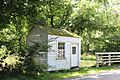
Bridge Tender’s Station
-
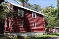
Lock Tender's House
-
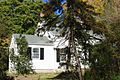
John Honeyman House
-
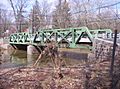
The Griggstown Causeway over the Millstone River


See also
 In Spanish: Griggstown para niños
