
Hillsdale County, Michigan facts for kids
Quick facts for kids
Hillsdale County
|
|
|---|---|

|
|

Location within the U.S. state of Michigan
|
|
 Michigan's location within the U.S. |
|
| Country | |
| State | |
| Founded | 1835 |
| Seat | Hillsdale |
| Largest city | Hillsdale |
| Area | |
| • Total | 607 sq mi (1,570 km2) |
| • Land | 598 sq mi (1,550 km2) |
| • Water | 8.9 sq mi (23 km2) 1.5%% |
| Population
(2020)
|
|
| • Total | 45,746 |
| • Density | 78/sq mi (30/km2) |
| Time zone | UTC−5 (Eastern) |
| • Summer (DST) | UTC−4 (EDT) |
| Congressional district | 7th |
Hillsdale County is a county located in the U.S. state of Michigan. As of the 2020 Census, the population was 45,746. The county seat is Hillsdale.
Due to an angle in the state's southern border, Hillsdale County has the southernmost boundary in the state and is the only county to border both Indiana and Ohio. Hillsdale County is conterminous with the Hillsdale, MI Micropolitan Statistical Area.
The Hillsdale County Courthouse was designed by Claire Allen, a prominent southern Michigan architect.
Contents
History
The county is named for its rolling terrain. It was set off in 1829, and organized six years later. See List of Michigan county name etymologies. Hillsdale County was a New England settlement. The original founders of Hillsdale consisted entirely of settlers from New England. These people were "Yankees", that is to say they were descended from the English Puritans who settled New England in the 1600s. They were part of a wave of New England farmers who headed west into what was then the wilds of the Northwest Territory during the early 1800s. Most of them arrived as a result of the completion of the Erie Canal as well as the close of the Black Hawk War. When they arrived in what is now Hillsdale County there was nothing but a virgin forest and wild prairie, the New Englanders laid out farms, constructed roads, erected government buildings and established post routes. They brought with them many of their Yankee New England values, such as a passion for education, establishing many schools as well as staunch support for abolitionism. They were mostly members of the Congregationalist Church though some were Episcopalian, however as a result of the Second Great Awakening many became Baptists and many also converted to Methodism before arriving in Michigan. The people of Hillsdale County, like many others in Michigan, maintained a cultural affinity with early New England.
Geography
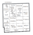
According to the U.S. Census Bureau, the county has a total area of 607 square miles (1,570 km2), of which 598 square miles (1,550 km2) is land and 8.9 square miles (23 km2) (1.5%) is water. Hillsdale is the only county in Michigan to border two other states. Within the county also exists the head waters of two St. Joseph Rivers, the St. Joseph River (Lake Michigan) and the St. Joseph River (Maumee River). The county is divided into 18 townships. From Northwest to Southeast, they are Litchfield, Scipio, Moscow, Somerset, Allen, Fayette, Hillsdale, Adams, Wheatland, Reading, Cambria, Jefferson, Pittsford, Camden, Woodbridge, Ransom, Amboy, and Wright.
Parks
- McCourtie Park
- Slayton Arboretum
Adjacent counties
- Jackson County (northeast)
- Calhoun County (northwest)
- Lenawee County (east)
- Branch County (west)
- Fulton County, Ohio (southeast)
- Williams County, Ohio (south)
- Steuben County, Indiana (southwest)
Climate
Hillsdale County experiences four distinct seasons. July is the hottest month with an average high of 82 °F or 27.8 °C and January the coldest with an average high of 29 °F or −1.7 °C. June is the wettest month with 4.29 inches or 109.0 millimetres of rain on average.
| Climate data for Hillsdale, Michigan | |||||||||||||
|---|---|---|---|---|---|---|---|---|---|---|---|---|---|
| Month | Jan | Feb | Mar | Apr | May | Jun | Jul | Aug | Sep | Oct | Nov | Dec | Year |
| Average high °F (°C) | 29 (−2) |
33 (1) |
43 (6) |
56 (13) |
68 (20) |
78 (26) |
82 (28) |
80 (27) |
72 (22) |
60 (16) |
46 (8) |
34 (1) |
57 (14) |
| Average low °F (°C) | 13 (−11) |
14 (−10) |
24 (−4) |
35 (2) |
45 (7) |
55 (13) |
59 (15) |
57 (14) |
49 (9) |
38 (3) |
29 (−2) |
19 (−7) |
36 (2) |
| Average precipitation inches (mm) | 2.10 (53) |
1.82 (46) |
2.77 (70) |
3.39 (86) |
3.82 (97) |
4.29 (109) |
3.54 (90) |
3.70 (94) |
3.71 (94) |
2.82 (72) |
3.07 (78) |
2.66 (68) |
37.69 (957) |
| Source: weather.com | |||||||||||||
Demographics
| Historical population | |||
|---|---|---|---|
| Census | Pop. | %± | |
| 1840 | 7,240 | — | |
| 1850 | 16,159 | 123.2% | |
| 1860 | 25,675 | 58.9% | |
| 1870 | 31,684 | 23.4% | |
| 1880 | 32,723 | 3.3% | |
| 1890 | 30,660 | −6.3% | |
| 1900 | 29,865 | −2.6% | |
| 1910 | 29,673 | −0.6% | |
| 1920 | 28,161 | −5.1% | |
| 1930 | 27,417 | −2.6% | |
| 1940 | 29,092 | 6.1% | |
| 1950 | 31,916 | 9.7% | |
| 1960 | 34,742 | 8.9% | |
| 1970 | 37,171 | 7.0% | |
| 1980 | 42,071 | 13.2% | |
| 1990 | 43,431 | 3.2% | |
| 2000 | 46,527 | 7.1% | |
| 2010 | 46,688 | 0.3% | |
| 2020 | 45,746 | −2.0% | |
| US Decennial Census 1790-1960 1900-1990 1990-2000 2010-2018 |
|||
As of the 2000 United States Census, there were 46,527 people, 17,335 households, and 12,550 families residing in the county. The population density was 78 people per square mile (30/km2). There were 20,189 housing units at an average density of 34 per square mile (13/km2). The racial makeup of the county was 97.56% White, 0.43% Black or African American, 0.35% Native American, 0.33% Asian, 0.01% Pacific Islander, 0.34% from other races, and 0.98% from two or more races. 1.20% of the population were Hispanic or Latino of any race. 28.4% were of German, 28.2% English and 9.3% Irish ancestry, 97.0% spoke English, 1.2% Spanish and 1.2% German as their first language.
There were 17,335 households, out of which 32.90% had children under the age of 18 living with them, 59.90% were married couples living together, 8.40% had a female householder with no husband present, and 27.60% were non-families. 22.90% of all households were made up of individuals, and 9.30% had someone living alone who was 65 years of age or older. The average household size was 2.60 and the average family size was 3.05.
The county's population contained 26.30% under the age of 18, 10.00% from 18 to 24, 26.80% from 25 to 44, 23.50% from 45 to 64, and 13.30% who were 65 years of age or older. The median age was 36 years. For every 100 females there were 99.00 males. For every 100 females age 18 and over, there were 96.20 males.
The median income for a household in the county was $40,396, and the median income for a family was $45,895. Males had a median income of $35,349 versus $23,718 for females. The per capita income for the county was $18,255. About 5.20% of families and 8.20% of the population were below the poverty line, including 8.80% of those under age 18 and 8.60% of those age 65 or over.
Transportation
Major highways
 US 12 crosses the county in a generally east–west direction for a distance of about 23 miles. US 12 is the southernmost US Highway in Michigan to go east and west.
 US 127 is the north–south highway running along a portion of the eastern boundary of the county and is also called Meridian Road as it runs along the Michigan meridian.
 M-34 is a highway from the eastern border of the county westward until it joins M-99. It is also known as Hudson Road.
 M-49 is a north–south highway running north from the Ohio border and intersects M-99 in the northwest corner of the county.
 M-99 crosses the county in a generally north–south direction for a distance of about 30 miles. It is also known as Carleton Road (named after the poet Will Carleton who attended Hillsdale College and lived in Hillsdale for a time.)
Airports
Hillsdale Municipal Airport (KJYM) established in 1963, has a 5000' paved and lighted runway with instrument approaches, hangars, tie-downs, and fuel services available. It allows general aviation access to Hillsdale County and nearby areas.
Trails
The 4000 mile National Scenic North Country Trail passes through the county in a north–south direction.
Communities
Cities
- Hillsdale (county seat)
- Jonesville
- Litchfield
- Reading
Villages
Unincorporated communities
- Amboy Center
- Austin
- Bankers
- Betzer
- Buckeye
- Cambria
- Church's Corners
- Fields Corners
- Fowlers Mill
- Frontier
- Jerome
- Lickley Corners
- Locust Corners
- Moscow
- Mosherville
- Osseo
- Pittsford
- Ransom
- Somerset
- Somerset Center
- Squawfield Corners
Townships
- Adams Township
- Allen Township
- Amboy Township
- Cambria Township
- Camden Township
- Fayette Township
- Hillsdale Township
- Jefferson Township
- Litchfield Township
- Moscow Township
- Pittsford Township
- Ransom Township
- Reading Township
- Scipio Township
- Somerset Township
- Wheatland Township
- Woodbridge Township
- Wright Township
Notable people
- Moses Allen, first settler and veteran of the War of 1812.
- Oscar F. Avery (1841–1924), lawyer and Illinois state senator, was born in Allen Township.
- Don A. Jones (1912–2000), admiral and civil engineer, seventh Director of the United States Coast and Geodetic Survey and second Director of the Environmental Science Services Administration Corps, born in Waldron.
Images for kids
-
U.S. Census data map showing local municipal boundaries within Hillsdale County. Shaded areas represent incorporated cities.

See also
 In Spanish: Condado de Hillsdale para niños
