
Hormigueros, Puerto Rico facts for kids
Quick facts for kids
Hormigueros
Municipio Autónomo de Hormigueros
|
|||
|---|---|---|---|
|
Town and Municipality
|
|||

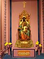
Basílica Menor de la Virgen de Monserrate
|
|||
|
|||
| Nicknames:
"El Pueblo de Nuestra Señora de la Monserrate", "El Pueblo del Milagro", "Los Peregrinos", "Corazón del Oeste"
|
|||
| Anthem: "Sobre un verde valle de mi linda Borinquén" | |||

Map of Puerto Rico highlighting Hormigueros Municipality
|
|||
| Commonwealth | Puerto Rico | ||
| Founded | 1874 | ||
| Founded by | Giraldo González de la Renta | ||
| Seat | Edificio Modesta Díaz Segarra | ||
| Barrios | |||
| Area | |||
| • Total | 11 sq mi (29 km2) | ||
| • Land | 11 sq mi (29 km2) | ||
| • Water | 0 sq mi (0 km2) | ||
| Population
(2020)
|
|||
| • Total | 15,654 | ||
| • Density | 1,398/sq mi (540/km2) | ||
| Demonym(s) | Hormiguereños | ||
| Time zone | UTC−4 (AST) | ||
| ZIP Code |
00660
|
||
| Area code(s) | 787/939 | ||
| Major routes | |||


Hormigueros is a town and municipality of Puerto Rico located in the western region of the island, northeast of Cabo Rojo; northwest of San Germán; and south of Mayagüez. Hormigueros is spread over 5 barrios and Hormigueros Pueblo (the downtown area and the administrative center). It is part of the Mayagüez Metropolitan Statistical Area.
Contents
History
The region of what is now Hormigueros belonged to the Guaynia region, located on the southernwest portion of Puerto Rico. Archaeological findings have established that there were tribes already settled in the region around 820 BC.
During the Spanish colonization at the beginning of the 16th century, it is possible that some of them settled in the area. A coffin found underground a basilica was tested in laboratories and was dated prior to 1600. Some historians also mentioned the Horomico river as one of the main sources of gold during the rush of the era. In 1692, the town of Hormigueros was first established, first as a village of Mayagüez.
From 1863 to 1873, residents of the area started petitioning for the area to be declared an independent town. In 1874, it was finally granted independence from San Germán.
Symbols
Flag
The town's flag is based on the towns shield. It consists of a blue cloth with a horizontal white rhombus. Superposed on the white rhombus is another blue rhombus with a white globe outlined in blue with a cross. The globe with the cross symbolises royalty and represents Christ's domain over the world. This symbol is a traditional attribute to the Virgin of Montserrat.
Coat of Arms
The town's shield is formed by a blue rhombus, with silver-plated edge. On the blue bottom there's a green hill which is a representation of Our Lady of Monserrate de Hormigueros' Sanctuary, with its silver stairway. The border has symmetrical black dots, on guard. On the top of the shield resides a crown formed by a wall, with three towers that have blue doors and windows. The joints of the stones are filled with blue lines. The shield is surrounded by two chains that begin at the crown and finish under the bottom part of the shield with the last links broken.
Name
The name of Hormigueros means "anthill" in English. The town possibly derives its name from three concepts. The first one refers to the crowds that gathered at the Basilica Menor on September 8 to honor the Virgin of Montserrat. The second refers to the topographic formation of the town which consists of countless hills resembling "anthills", reason why it was called "Valle del Hormiguero" or "Anthill Valley". Third, it is possible that the name was originated from a Taíno word: Horomico, which means "río de oro" or "river of gold" due to the importance of the rivers in the area during the gold rush of the Spanish colonization.
Geography
The municipality of Hormigueros can be divided in three areas: the northern mountainous region that covers one fourth of the town, with hills of relative height; a semi-mountainous region that extends from east to west covering downtown Hormigueros; and the flat, valley-like region that extends towards the south covering 5.6 square miles. It is the second-smallest Puerto Rican municipality in land area, larger than only Cataño.
Climate
The climate conditions of Hormigueros are hot and humid. The average temperature is of 72°F to 79°F.
Cityscape
Barrios
The town of Hormigueros is divided itself into several barrios or districts:
- Benavente
- Guanajibo
- Hormigueros
- Hormigueros Pueblo
- Jaguitas
- Lavadero
To get source about the Hormigueros districts : http://ceepur.org/censo2000/barrios.php?municipio=HS
Some urbanizations are located outside Hormigueros downtown:
- Buenaventura (Goodwill)
- San Romualdo Norte (North Saint Ronald)
- San Romualdo Sur (South Saint Ronald)
- Valle Hermoso Norte (North Beautiful Valley)
- Valle Hermoso Sur (South Beautiful Valley)
Culture
Tourism
Despite its small size, Hormigueros still has several few attractions for visitors. Some of them are:
- Birán Recreational Farm
- Central Eureka (sugar refinery)
- Basilica Menor de la Virgen de Monserrate
The economy of Hormigueros is still developing. In the 1980s and '90s Allergan, Inc. (a pharmaceutical company) had a subsidiary established in town boosting the economic development of Hormigueros. However, after Allergan left no other private industry has opened operations in Hormigueros. On the other hand, Hormigueros does provide abundant land, talent and accessibility for an economic development and expansion. Not far away there are two regional airports: Eugenio María de Hostos Airport at Mayaguez and Mercedita Airport at Ponce. In addition, there is Rafael Hernández International Airport at Aguadilla. All three airports lie within 30 miles approximately.
Demographics
| Historical population | |||
|---|---|---|---|
| Census | Pop. | %± | |
| 1900 | 3,215 | — | |
| 1910 | 3,887 | 20.9% | |
| 1920 | 4,584 | 17.9% | |
| 1930 | 4,872 | 6.3% | |
| 1940 | 6,098 | 25.2% | |
| 1950 | 6,916 | 13.4% | |
| 1960 | 7,153 | 3.4% | |
| 1970 | 10,827 | 51.4% | |
| 1980 | 14,030 | 29.6% | |
| 1990 | 15,212 | 8.4% | |
| 2000 | 16,614 | 9.2% | |
| 2010 | 17,250 | 3.8% | |
| 2020 | 15,654 | −9.3% | |
| U.S. Decennial Census 1899 (shown as 1900) 1910–1930 1930–1950 1960–2000 2010 2020 |
|||
| Race – Hormigueros, Puerto Rico – 2000 Census | ||
|---|---|---|
| Race | Population | % of Total |
| White | 14,283 | 86.0% |
| Black/African American | 811 | 4.9% |
| American Indian and Alaska Native | 31 | 0.2% |
| Asian | 21 | 0.1% |
| Native Hawaiian/Pacific Islander | 4 | 0.0% |
| Some other race | 1,063 | 6.4% |
| Two or more races | 401 | 2.4% |
Hormigueros is one of the least populated municipalities. The population, according to the 2000 census, was 16,614 with a population density of 1,510.3 people per square mile (580.9/km2). Since the 1950s, the population has more than doubled.
Statistics taken from the 2000 census shows that 86.0% of Hormiguereños self-identify as Spanish or white origin, 4.9% as black, 0.2% as indigenous or other.
Transportation
Puerto Rico Highway 2 provides access to Hormigueros from the nearby city of Mayagüez, or from Ponce. The rest of the roads in the town are mostly rural.
It has a public transportation system consisting of public cars. Taxis are also available around the town.
There are 16 bridges in Hormigueros.
Economy
The economy of Hormigueros is still developing. In the 1980s and 90s Allergan, Inc. had a subsidiary established in town boosting the economic development of Hormigueros. However, after Allergan left no other private industry has opened operations in the municipality. On the other hand, Hormigueros does provide abundant land, talent and accessibility for an economic development and expansion. Not far away there are two regional airports: Eugenio María de Hostos Airport at Mayagüez and Mercedita Airport at Ponce. In addition, there is the Rafael Hernández International Airport at Aguadilla. All three airports lie within 30 miles approximately.
Education
Hormigueros boasts several public and private schools within its territory. Public education is handled by the Puerto Rico Department of Education, specifically the Mayaguez Local Educational Agency (LEA).
The local schools are:
Elementary schools
- Escuela Elemental Nueva
Middle schools
- Ramon Rodríguez Diaz
High schools
- Segundo Ruiz Belvis
Second unit (elementary and middle)
- Alfredo Dorrington Farinacci
Higher education
At the same time, most of the population (21–35) has either a bachelor or a higher degree, making the town one of the most talented ones in the Island of Puerto Rico.
Images for kids
-
Virgen de La Monserrate at the Museo de las Americas in San Juan, Puerto Rico
-
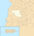
Subdivisions of Hormigueros.


See also
 In Spanish: Hormigueros (Puerto Rico) para niños
