
Cabo Rojo, Puerto Rico facts for kids
Quick facts for kids
Cabo Rojo
Municipio Autónomo de Cabo Rojo
|
|||
|---|---|---|---|
|
City and Municipality
|
|||

Collage of Cabo Rojo
|
|||
|
|||
| Nicknames:
"Cuna de Cofresí", "Los Mata con Hacha", "Ciudad Maravillosa", "Cuna de Betances", "Capital del Turismo"
|
|||
| Anthem: "Mi Cabo Rojo Querido" | |||

Map of Puerto Rico highlighting Cabo Rojo Municipality
|
|||
| Commonwealth | |||
| Founded | December 17, 1771 | ||
| Barrios | |||
| Area | |||
| • City and Municipality | 177.40 sq mi (459.5 km2) | ||
| • Land | 70.35 sq mi (182.2 km2) | ||
| • Water | 107.05 sq mi (277.3 km2) | ||
| Population
(2020)
|
|||
| • City and Municipality | 47,158 | ||
| • Density | 265.829/sq mi (102.637/km2) | ||
| • Metro | 136,212 | ||
| • CSA | 251,260 | ||
| Demonym(s) | Caborrojeños | ||
| Time zone | UTC−4 (AST) | ||
| ZIP Codes |
00623, 00622
|
||
| Area code(s) | 787/939 | ||
| Major routes | |||


Cabo Rojo is a city and municipality situated on the southwest coast of Puerto Rico and forms part of the San Germán–Cabo Rojo metropolitan area as well as the larger Mayagüez–San Germán–Cabo Rojo Combined Statistical Area.
Contents
History
The area of near Las Salinas (salt flats) has been inhabited since 30 BC and AD 120 according to archaeological evidence. Punta Ostiones, listed in the National Register of Historic Places as an archeological site, was home to a large group of Archaic Indians.
Despite the threat of pirates and Indians, the Spanish settled the area of Los Morrillos around 1511. By 1525, salt mining was an important industry in the area.
According to Fray Iñigo Abbad y Lasierra by the end of the 18th century, Cabo Rojo had a population of 1,215 people.
In 1759 the first request to establish itself as a town was denied. Cabo Rojo was founded on December 17, 1771 by Nicolás Ramírez de Arellano, a descendant of Spanish royalty and nobility, with the approval of Governor Miguel de Muesas.
Geography
The Municipality of Cabo Rojo sits in the southern-west corner of the island of Puerto Rico, on the Western Coastal Plains. It is bordered by Mayagüez and Hormigueros to the north, San Germán and Lajas to the east, the Caribbean Sea to the south and the Mona Passage to the west. Cabo Rojo has a surface area of 72 square miles (187 km2).
Cabo Rojo's terrain is plain. However, some notable peaks are Mariquita, Buena Vista, Vargas, and Peñones de Melones.
| Month | Jan | Feb | Mar | Apr | May | Jun | Jul | Aug | Sep | Oct | Nov | Dec | Year |
|---|---|---|---|---|---|---|---|---|---|---|---|---|---|
| Record high °C (°F) | 33 (91) |
33 (92) |
35 (95) |
35 (95) |
35 (95) |
37 (99) |
37 (99) |
36 (97) |
37 (98) |
36 (97) |
37 (98) |
37 (98) |
35.7 (96.2) |
| Average high °C (°F) | 31 (87) |
31 (87) |
31 (88) |
32 (89) |
32 (90) |
33 (91) |
33 (92) |
33 (92) |
33 (91) |
32 (90) |
32 (89) |
31 (88) |
31.9 (89.5) |
| Daily mean °C (°F) | 24 (75) |
24 (75) |
24 (76) |
26 (78) |
27 (80) |
27 (81) |
27 (81) |
27 (81) |
27 (81) |
27 (80) |
26 (78) |
24 (76) |
25.8 (78.5) |
| Average low °C (°F) | 17 (62) |
17 (62) |
18 (64) |
19 (66) |
21 (69) |
22 (71) |
21 (70) |
21 (70) |
21 (70) |
21 (69) |
19 (67) |
17 (63) |
19.4 (66.9) |
| Record low °C (°F) | 7 (44) |
11 (51) |
10 (50) |
10 (50) |
13 (56) |
14 (58) |
12 (53) |
14 (58) |
16 (60) |
13 (56) |
12 (53) |
9 (49) |
11.8 (53.2) |
| Average rainfall mm (inches) | 64 (2.51) |
56 (2.19) |
56 (2.19) |
87 (3.43) |
131 (5.14) |
69 (2.70) |
80 (3.13) |
133 (5.23) |
157 (6.20) |
185 (7.29) |
145 (5.71) |
59 (2.33) |
1,220 (48.05) |
| Source: Weather.com | |||||||||||||
Cityscape
Barrios

The municipality is spread over 9 barrios/wards and Cabo Rojo Pueblo, its downtown and administrative center. Cabo Rojo is a principal municipality of the San Germán–Cabo Rojo metropolitan area as well as the larger Mayagüez–San Germán–Cabo Rojo Combined Statistical Area.
- Bajura
- Boquerón, Cabo Rojo
- Cabo Rojo Pueblo
- Guanajibo
- Llanos Costa
- Llanos Tuna
- Miradero
- Monte Grande
- Pedernales
Tourism
Its tourism industry has flourished with the development of hotels and marinas, but local and international environmentalists are concerned that this development will endanger Cabo Rojo's rich and beautiful beaches, sunsets and natural resources. Cabo Rojo is also well known for its fishing, particularly the Puerto Real fishing village, and its many seafood restaurants, most of which are found in the barrio of Joyuda.
Landmarks and places of interest


The San Miguel Arcángel Church, in the town plaza, was built between 1773 and completed in 1783.The famous Cabo Rojo lighthouse, Los Morrillos Lighthouse, known by locals as El Faro, was built in 1881 over limestone cliffs that rise 200 feet above sea level. This old lighthouse was automated and electrically charged in 1967 and is considered to have some, if not, the most spectacular ocean views on Puerto Rico's west coast. The lighthouse has undergone recent renovations, which has created controversy because of the quality of the work. According to locals and scholars, the internal structure was gutted leaving nothing of historical significance behind.
The lighthouse is located near the Salinas, or salt mines. These salt mines are reported to be the oldest industry in the New World. Salt has been mined in this site non-stop since the times of the Taínos. Near the Salinas, a local civic group Caborrojeños Pro Salud y Ambiente run a visitor's center known as the Centro Interpretativo Las Salinas De Cabo Rojo don Efrén Pérez Rivera. They offer free guided tours of the local area, which is rich in flora and fauna.
- Boquerón Beach
- Cofresí Cave
- El Combate Beach
- Joyuda Beach
- Joyuda Lagoon
- Market Plaza
- Club Deportivo del Oeste
- Nautical Club
- Punta Arenas Beach
- Punta Real Beach
- Isla de Ratones
- Buyé Beach
- The Lighthouse (El Faro) Beach
- La Playuela in Los Morrillos (El Faro)
National protected areas
- The Cabo Rojo National Wildlife Refuge is home for a number of native bird species including the endangered yellow-shouldered blackbird also known as la mariquita de Puerto Rico or capitán.
- The Boquerón State Forest is one of seven state forests managed by the Puerto Rico Department of Natural and Environmental Resources.
Culture
Festivals and events
- Pescao Festival - March
- Años Cuarenta Festival - April
- Chigüero Festival - April
- Betances Festival - April
- Oyster Festival - May
- Boquerón Bay Crossing - July
- Watermelon Festival - July
- Retorno a la Arena - July
- Patron Festivities - September
- La Pileta Festival - December
- Le Lo Lai Festival - December
Sports
Cabo Rojo had a BSN basketball team, Los Turistas de Cabo Rojo (the "Cabo Rojo Tourists") from 1989 to 1993.
Indias de Mayagüez, female Volleyball team from Liga de Voleibol Superior Femenino played the 2009 season at the Coliseo Rebekah Colberg Cabrera, because their home ground, Palacios de los Deportes, was under remodeling.
Symbols
Flag
The flag contains elements of the coat of arms, excluding the sword, the anchors and the crown.
Coat of Arms
The point or red triangle symbolizes the "Cabo Bermejo" (Vermillion Cape) in Los Morillos. The blue and white, with the anchors, represent the sea that bathes our coasts. The flaming sword, is an attribute to San Miguel de Arcángel, patron of the town. Finally, the crown, which heightens and distinguishes the shield, stands for the status of municipality.
Transportation
Although Cabo Rojo lacks an airport, it is approximately 11 miles from the Eugenio María de Hostos Airport (MAZ) in Mayagüez, a commercial airport that serves direct flights to and from San Juan. Cabo Rojo has grown tremendously in the last few years as evidenced by its accreditation as a city. Cabo Rojo's nearest airport servicing international destinations is forty-five minutes away in Aguadilla's Rafael Hernández Airport (BQN). This airport was part of the now deactivated Ramey Air Force Base.
PR-100 is the main highway in the city, connecting northward to PR-2 between Hormigueros and Mayagüez, and southward to the Boquerón sector. Other mayor roads include PR-101, which connects to Lajas, PR-102, connecting to Mayagüez and San Germán, PR-103, an older road which parallels the newer PR-100, and PR-301, connecting to El Combate sector and the Los Morrillos Lighthouse.
There are 20 bridges in Cabo Rojo.
Notable Caborrojeños

The following is a list of notable Caborrojeños:
- Antonio Fas Alzamora is the second-longest serving member of the Puerto Rico Legislative Assembly.
- Ramón Emeterio Betances y Alacán (1827–1898) was a nationalist. He was the primary instigator of the Grito de Lares revolution and, as such, is considered to be the father of the Puerto Rican independence movement and, as well, the Father of the Country.
- Dr. Salvador Brau y Asencio (1842–1912) was a journalist, poet, writer and also a historian.
- Roberto Cofresí y Ramírez de Arellano (1791–1825), better known as "El Pirata Cofresí", was a pirate in Puerto Rico.
- Elisa Colberg (1903–1988) was the founder of the Puerto Rican Girl Scouts, the first troop of which formed in 1926 in Cabo Rojo.
- Santos Ortiz Ruíz First and only mayor to be elected outside a political party in 1988. No one has been able to achieve that since.
- Efrén Pérez Rivera is a former college professor and noted Puerto Rican environmentalist leader.
- Colonel Carlos Betances Ramírez (1910–2001), was the only Puerto Rican to command a Battalion in the Korean War.
- Dra. Rebekah Colberg (1918–1985), is known as "The Mother of Women's Sports in Puerto Rico".
- Ramón López Irizarry (1897–1982) was an educator and scientist who invented an easier way to extract the cream from the coconut pulp and developed the original formula of "Coco Lopez".
Due to space limitations it is almost impossible to list all of the people of Cabo Rojo who have distinguished themselves, therefore a category has been created to this effect:
Demographics
Puerto Rico was ceded by Spain in the aftermath of the Spanish–American War under the terms of the Treaty of Paris of 1898 and became an unincorporated territory of the United States. In 1899, the United States Department of War conducted a census of Puerto Rico finding that the population of Cabo Rojo was 16,154.
| Historical population | |||
|---|---|---|---|
| Census | Pop. | %± | |
| 1900 | 16,154 | — | |
| 1910 | 19,562 | 21.1% | |
| 1920 | 22,412 | 14.6% | |
| 1930 | 23,792 | 6.2% | |
| 1940 | 28,586 | 20.1% | |
| 1950 | 29,546 | 3.4% | |
| 1960 | 24,868 | −15.8% | |
| 1970 | 26,060 | 4.8% | |
| 1980 | 34,045 | 30.6% | |
| 1990 | 38,521 | 13.1% | |
| 2000 | 46,911 | 21.8% | |
| 2010 | 50,917 | 8.5% | |
| 2020 | 47,158 | −7.4% | |
| U.S. Decennial Census 1899 (shown as 1900) 1910–1930 1930–1950 1960–2000 2010 2020 |
|||
Images for kids
-
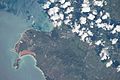
Picture of Cabo Rojo taken during ISS Expedition 53
-
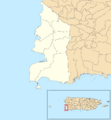
Subdivisions of Cabo Rojo
-
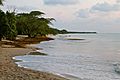
Playa Sucia in Cabo Rojo
-
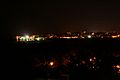
View of Puerto Real in Cabo Rojo at night
-
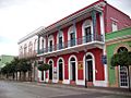
Historic buildings at Ruiz Belvis St.
-
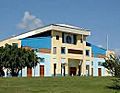
Coliseo Rebekah Colberg


See also
 In Spanish: Cabo Rojo para niños
