
Image: Location map of Middlesex County, New Jersey

Size of this PNG preview of this SVG file: 700 × 600 pixels. Other resolution: 280 × 240 pixels.
Original image (SVG file, nominally 896 × 768 pixels, file size: 880 KB)
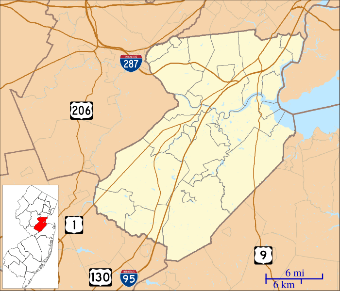
Description: This is a map of Middlesex County, New Jersey, USA which includes incorporated settlements, township borders, and major highways.
Title: Location map of Middlesex County, New Jersey
Credit: My own work, using custom-written MapScript applications with United States Census Bureau data
Author: Omnedon
Usage Terms: Public domain
License: Public domain
Attribution Required?: No
Image usage
More than 100 pages link to this image. The following list shows the first 100 page links to this image only. A full list is available.
- Adams, New Jersey
- Alexander Johnston Hall
- Applegarth, New Jersey
- Ayers-Allen House
- Benjamin Shotwell House
- Bishop House (New Brunswick, New Jersey)
- Bonhamtown, New Jersey
- Brookview, New Jersey
- Browntown, New Jersey
- Buccleuch Mansion
- Buckelew Mansion
- Carteret, New Jersey
- Cheesequake, New Jersey
- Chrome, New Jersey
- Clara Barton, New Jersey
- Cornelius Low House
- Cottageville, New Jersey
- Cottrell Corners, New Jersey
- Cranbury, New Jersey
- Dayton, New Jersey
- Deans, New Jersey
- Dunellen, New Jersey
- East Brunswick, New Jersey
- East Spotswood, New Jersey
- Edgars, New Jersey
- Edgebrook, New Brunswick
- Edison, New Jersey
- Ernston, New Jersey
- Fieldville, New Jersey
- Fresh Ponds, New Jersey
- Geology Hall, New Brunswick, New Jersey
- Gillespie, New Jersey
- Gravel Hill, New Jersey
- Great Beds Light
- Half Acre, New Jersey
- Halls Corner, New Jersey
- Harbortown, Perth Amboy
- Helmetta, New Jersey
- Henry Guest House
- Highland Park, New Jersey
- Hoffman, New Jersey
- Homestead Farm at Oak Ridge
- Hopelawn, New Jersey
- Jamesburg, New Jersey
- Jonathan Singletary Dunham House
- Kearny Cottage
- Keasbey, New Jersey
- Laing House of Plainfield Plantation
- Levi D. Jarrard House
- Little Rocky Hill, New Jersey
- Livingston Avenue Historic District
- Maurer, Perth Amboy
- Melrose, New Jersey
- Metlar–Bodine House
- Metuchen, New Jersey
- Metuchen Borough Hall
- Middlesex Downs, New Jersey
- Milltown, New Jersey
- Morgan, New Jersey
- New Brunswick, New Jersey
- New Dover, New Jersey
- New Durham, Middlesex County, New Jersey
- New Jersey Hall
- New Market, Middlesex County, New Jersey
- Newtown, New Jersey
- Nixon, New Jersey
- North Brunswick, New Jersey
- North Stelton, New Jersey
- Old Bridge Township, New Jersey
- Old Queens
- Orchard Heights, New Jersey
- Parlin, New Jersey
- Perth Amboy, New Jersey
- Perth Amboy City Hall
- Perth Amboy Ferry Slip
- Piscataway, New Jersey
- Plainsboro Township, New Jersey
- Possumtown, New Jersey
- Potters, New Jersey
- Prospect Plains, New Jersey
- Pumptown, New Jersey
- Randolphville, New Jersey
- Raritan Gardens, New Brunswick
- Raritan Landing, New Jersey
- Runyon Watershed
- Sand Hills, South Brunswick, New Jersey
- Sayerwood South, New Jersey
- Sayreville, New Jersey
- Sayreville Junction, New Jersey
- Sayreville Station, New Jersey
- Schalks, New Jersey
- Shore Road Estates, New Jersey
- South Amboy, New Jersey
- Spotswood Manor, New Jersey
- Stelton, New Jersey
- Tracy, New Jersey
- Union Valley, New Jersey
- West Carteret, New Jersey
- Westons Mills, New Jersey
- Woodbridge Township, New Jersey

All content from Kiddle encyclopedia articles (including the article images and facts) can be freely used under Attribution-ShareAlike license, unless stated otherwise.