
Milford, Utah facts for kids
Quick facts for kids
Milford, Utah
|
|
|---|---|

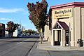
Milford train station, October 2017
|
|

Location in Beaver County and the state of Utah
|
|

Location of Utah in the United States
|
|
| Country | United States |
| State | Utah |
| County | Beaver |
| Founded | 1880 |
| Incorporated | 1903 |
| Area | |
| • Total | 2.14 sq mi (5.54 km2) |
| • Land | 2.14 sq mi (5.54 km2) |
| • Water | 0.00 sq mi (0.00 km2) |
| Elevation | 4,967 ft (1,514 m) |
| Population
(2010)
|
|
| • Total | 1,409 |
| • Estimate
(2019)
|
1,394 |
| • Density | 651.10/sq mi (251.44/km2) |
| Time zone | UTC-7 (Mountain (MST)) |
| • Summer (DST) | UTC-6 (MDT) |
| ZIP code |
84751
|
| Area code(s) | 435 |
| FIPS code | 49-50040 |
| GNIS feature ID | 1430317 |
Milford is a city in Beaver County, Utah, United States. The population was 1,409 at the 2010 census and 1,394 as of a 2019 Census Bureau estimate.
Contents
History
Although settlers had established ranches in the area in the 1870s, Milford was not developed until after construction of the San Pedro, Los Angeles and Salt Lake Railroad in 1880, which established a station here. Milford is a constructed name, an abbreviated form of mill and ford.

During the Great Depression, workers from a nearby CCC camp constructed a road from Milford to Beaver, Utah, to improve connections.
Milford Flat Wildfire
Lightning caused a massive wildfire to start near Milford at 3:45 p.m. Friday, July 6, 2007. On July 8 the fire was declared the largest in Utah's history, having burned more than 283,000 acres (1,150 km2).
Demographics
| Historical population | |||
|---|---|---|---|
| Census | Pop. | %± | |
| 1890 | 576 | — | |
| 1900 | 176 | −69.4% | |
| 1910 | 1,014 | 476.1% | |
| 1920 | 1,308 | 29.0% | |
| 1930 | 1,517 | 16.0% | |
| 1940 | 1,393 | −8.2% | |
| 1950 | 1,673 | 20.1% | |
| 1960 | 1,471 | −12.1% | |
| 1970 | 1,304 | −11.4% | |
| 1980 | 1,293 | −0.8% | |
| 1990 | 1,107 | −14.4% | |
| 2000 | 1,451 | 31.1% | |
| 2010 | 1,409 | −2.9% | |
| 2019 (est.) | 1,394 | −1.1% | |
| U.S. Decennial Census | |||
As of the 2000 census, there were 1,451 people, 484 households, and 357 families residing in the city. The population density was 753.7 people per square mile (290.3/km2). There were 589 housing units at an average density of 306.0 per square mile (117.8/km2). The racial makeup of the city was 90.42% White, 1.45% Native American, 1.45% Asian, 4.07% from other races, and 2.62% from two or more races. Hispanic or Latino of any race were 6.13% of the population.
There were 484 households, out of which 45.0% had children under the age of 18 living with them, 61.0% were married couples living together, 9.3% had a female householder with no husband present, and 26.2% were non-families. 24.0% of all households were made up of individuals, and 14.7% had someone living alone who was 65 years of age or older. The average household size was 2.95 and the average family size was 3.58.
In the city, the population was spread out, with 37.2% under the age of 18, 9.7% from 18 to 24, 23.6% from 25 to 44, 17.2% from 45 to 64, and 12.3% who were 65 years of age or older. The median age was 28 years. For every 100 females, there were 97.4 males. For every 100 females age 18 and over, there were 95.1 males.
The median income for a household in the city was $35,809, and the median income for a family was $41,750. Males had a median income of $35,568 versus $19,000 for females. The per capita income for the city was $14,889. About 9.2% of families and 10.8% of the population were below the poverty line, including 11.1% of those under age 18 and 17.4% of those age 65 or over.
Geography and climate
Milford is located in east-central Beaver County in the Escalante Desert, a basin situated between the Mineral Mountains to the east and the smaller Star Range to the west. State Route 21 passes through the city, leading south 14 miles (23 km) to Minersville and northwest 84 miles (135 km) to U.S. Routes 6 and 50 near the Nevada line. State Route 257 runs north from Milford 74 miles (119 km) to Delta.
According to the United States Census Bureau, the city has a total area of 3.1 square miles (8.0 km2), all of it land.
| Monthly Normal and Record High and Low Temperatures | ||||||||||||
| Month | Jan | Feb | Mar | Apr | May | Jun | Jul | Aug | Sep | Oct | Nov | Dec |
|---|---|---|---|---|---|---|---|---|---|---|---|---|
| Rec High °F | 66 | 75 | 80 | 87 | 94 | 105 | 104 | 102 | 98 | 90 | 76 | 65 |
| Norm High °F | 40.6 | 47.1 | 56.7 | 65 | 74.2 | 86.2 | 92.9 | 90.7 | 81.3 | 68 | 52.2 | 42.2 |
| Norm Low °F | 15.5 | 20.2 | 26.4 | 31.6 | 38.9 | 47.1 | 55.4 | 54.5 | 44.9 | 33.1 | 23 | 15 |
| Rec Low °F | -28 | -29 | -14 | 9 | 17 | 24 | 38 | 34 | 23 | -2 | -13 | -32 |
| Precip (in) | 0.73 | 0.77 | 1.21 | 0.99 | 0.94 | 0.44 | 0.76 | 1.04 | 0.92 | 1.12 | 0.77 | 0.58 |
| Source: USTravelWeather.com [1] | ||||||||||||
Historic photo gallery
-
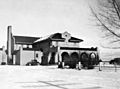
Train depot in Milford, Utah, during the winter of 1936-1937 -
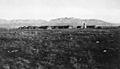
Civilian Conservation Corp camp at Milford, Utah -
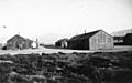
Barracks at CCC camp 2530


 |
Sevier Lake |
Hinckley, Delta Meadow Kanosh |
|
|
| Joseph Fishlake National Forest / Marysvale |
||||
| Minersville | Beaver |
Images for kids
-
Facing east along West Center Street (SR-21), October 2017
-
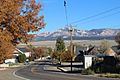
Looking north on South Main Street (SR-21), October 2017


See also
 In Spanish: Milford (Utah) para niños
