Montague County, Texas facts for kids
Quick facts for kids
Montague County
|
|
|---|---|
|
County
|
|

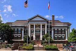
The Montague County Courthouse in Montague
|
|

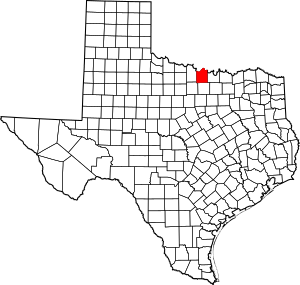
Location within the U.S. state of Texas
|
|
 Texas's location within the U.S. |
|
| Country | |
| State | |
| Founded | 1858 |
| Seat | Montague |
| Largest city | Bowie |
| Area | |
| • Total | 938 sq mi (2,430 km2) |
| • Land | 931 sq mi (2,410 km2) |
| • Water | 7.4 sq mi (19 km2) 0.8% |
| Population
(2020)
|
|
| • Total | 19,965 |
| • Density | 21.285/sq mi (8.218/km2) |
| Time zone | UTC−6 (Central) |
| • Summer (DST) | UTC−5 (CDT) |
| Congressional district | 13th |
Montague County ( MAHN-tayg) is a county located in the U.S. state of Texas, established in 1857. As of the 2020 census, its population was 19,965. The county seat is Montague. The county was created in 1857 and organized the next year. It is named for Daniel Montague, a surveyor and soldier in the Mexican–American War. Republican Drew Springer, Jr., a businessman from Muenster in Cooke County, represents Montague County in the Texas House of Representatives. He carried the county in the 2012 Republican runoff election.
Contents
History
On July 9, 2001, Governor Rick Perry issued a state of disaster for Montague County relating to substantial fires which had ravaged large portions of the county. In later interviews, Governor Perry called the fire "the most vicious" he'd ever seen.
On September 26, 2009, an historical marker on the Chisholm Trail was unveiled at the site of the former community of Red River Station in Montague County. The 5.5-foot concrete marker is the last of twelve erected in Montague County as part of a joint project of the Texas Lakes Trail and the Montague County Historical Commission to outline the Chisholm Trail.
Geography
According to the U.S. Census Bureau, the county has a total area of 938 square miles (2,430 km2), of which 931 square miles (2,410 km2) is land and 7.4 square miles (19 km2) (0.8%) is water.
Adjacent counties
- Jefferson County, Oklahoma (north)
- Love County, Oklahoma (northeast)
- Cooke County (east)
- Wise County (south)
- Jack County (southwest)
- Clay County (west)
National protected area
Demographics
| Historical population | |||
|---|---|---|---|
| Census | Pop. | %± | |
| 1860 | 849 | — | |
| 1870 | 890 | 4.8% | |
| 1880 | 11,257 | 1,164.8% | |
| 1890 | 18,863 | 67.6% | |
| 1900 | 24,800 | 31.5% | |
| 1910 | 25,123 | 1.3% | |
| 1920 | 22,200 | −11.6% | |
| 1930 | 19,159 | −13.7% | |
| 1940 | 20,442 | 6.7% | |
| 1950 | 17,070 | −16.5% | |
| 1960 | 14,893 | −12.8% | |
| 1970 | 15,326 | 2.9% | |
| 1980 | 17,410 | 13.6% | |
| 1990 | 17,274 | −0.8% | |
| 2000 | 19,117 | 10.7% | |
| 2010 | 19,719 | 3.1% | |
| 2020 | 19,965 | 1.2% | |
| U.S. Decennial Census 1850–2010 2010 2020 |
|||
2020 census
| Race / Ethnicity | Pop 2010 | Pop 2020 | % 2010 | % 2020 |
|---|---|---|---|---|
| White alone (NH) | 17,347 | 16,342 | 87.97% | 81.85% |
| Black or African American alone (NH) | 38 | 73 | 0.19% | 0.37% |
| Native American or Alaska Native alone (NH) | 137 | 155 | 0.69% | 0.78% |
| Asian alone (NH) | 59 | 84 | 0.30% | 0.42% |
| Pacific Islander alone (NH) | 3 | 4 | 0.02% | 0.02% |
| Some Other Race alone (NH) | 3 | 34 | 0.02% | 0.17% |
| Mixed Race/Multi-Racial (NH) | 202 | 912 | 1.02% | 4.57% |
| Hispanic or Latino (any race) | 1,930 | 2,361 | 9.79% | 11.83% |
| Total | 19,719 | 19,965 | 100.00% | 100.00% |
Note: the US Census treats Hispanic/Latino as an ethnic category. This table excludes Latinos from the racial categories and assigns them to a separate category. Hispanics/Latinos can be of any race.
Transportation
Major highways
 U.S. Highway 81
 U.S. Highway 82
 U.S. Highway 287
 State Highway 59
 State Highway 101
 State Highway 175
Farm to Market Roads
Communities
Cities
Census-designated places
Other unincorporated communities
Ghost town
- Red River Station
Education
These school districts serve Montague County:
- Alvord ISD (mostly in Wise County)
- Bowie ISD (small portion in Clay, Jack Counties)
- Forestburg ISD
- Gold-Burg ISD (small portion in Clay County)
- Montague ISD
- Nocona ISD
- Prairie Valley ISD
- Saint Jo ISD (small portion in Cooke County)
- Slidell ISD (partly in Wise, Denton counties; small portion in Cooke County)
In addition, a branch of North Central Texas College operates in Bowie.
See also
 In Spanish: Condado de Montague para niños

