
Montauban facts for kids
Quick facts for kids
Montauban
|
||
|---|---|---|

The Pont Vieux and the Ingres Museum
|
||
|
||
| Country | France | |
| Region | Occitanie | |
| Department | Tarn-et-Garonne | |
| Arrondissement | Montauban | |
| Canton | Chief town of 3 cantons | |
| Intercommunality | Pays de Montauban et des Trois Rivières | |
| Area
1
|
135.17 km2 (52.19 sq mi) | |
| Population
(2013)
|
57,921 | |
| • Density | 428.505/km2 (1,109.82/sq mi) | |
| Demonym(s) | Montalbanais | |
| Time zone | UTC+01:00 (CET) | |
| • Summer (DST) | UTC+02:00 (CEST) | |
| INSEE/Postal code |
82121 /82000
|
|
| Elevation | 72–207 m (236–679 ft) (avg. 140 m or 460 ft) |
|
| Website | www.montauban.com | |
| 1 French Land Register data, which excludes lakes, ponds, glaciers > 1 km2 (0.386 sq mi or 247 acres) and river estuaries. | ||
.svg)
Montauban (Occitan: Montalban) is a commune in the Tarn-et-Garonne department in the Midi-Pyrénées region in southern France. It is the préfecture (capital) of the department.
The town, built mainly with reddish bricks, is on the right bank of the Tarn river at its confluence with the Tescou. It was one of the first bastides in history.
Contents
History

Together with Mont-de-Marsan, Montauban is one of the oldest towns with walls (a bastide) in southern France. It was founded in 1144 by Alphonse Jourdain, Count of Toulouse. Most of the inhabitants came from Montauriol, a village which had grown up around the neighbouring monastery of St Théodard.
In the 13th century the town suffered much during the Albigensian Crusade and from the Inquisition, but by 1317 it had recovered sufficiently to be chosen by the Pope John XXII as the head of a diocese of which the basilica of St Théodard became the cathedral.
In 1360, under the Treaty of Brétigny, the town was given to the English; they were expelled by the inhabitants in 1414. In 1560 the bishops became Protestants; ten years later it became one of the four Huguenot strongholds under the Peace of Saint-Germain, and formed a small independent republic.
In 1790, Montauban was in the Lot department as the capital of a district; with the creation of the arrondissements in 1800, Montauban became a sous-préfecture in the Lot deparment. When Napoleon created the Tarn-et-Garonne department in 1809, Montauban became the préfecture (capital) of the new department.
Geography
Montauban is at about 50 km (31 mi) to the north of Toulouse, on the confluence of the Tescou and the Tarn rivers, and at 80 km (50 mi) from Agen (préfecture of the Lot-et-Garonne), 76 km (47 mi) from Albi (préfecture of the Tarn) and at about 60 km (37 mi) from Cahors (préfecture of the Lot).
It has an area of 135.17 km2 (52.19 sq mi) and its average altitude is 140 m (460 ft); at the city hall, the altitude is 103 m (338 ft).
 |
Montauban is surrounded by the communes Villemade, Piquecos, Lamothe-Capdeville, Albias, Saint-Étienne-de-Tulmont, Léojac, Saint-Nauphary,Corbarieu,Bressols, Lacourt-Saint-Pierre, Montbeton and Albefeuille-Lagarde.
 |
Villemade | Piquecos and Lamothe-Capdeville | Albias | |
| Lacourt-Saint-Pierre, Montbeton and Albefeuille-Lagarde | Saint-Étienne-de-Tulmont and Léojac | |||
| Bressols | Corbarieu | Saint-Nauphary |
Climate
The climate of Montauban, in the Köppen climate classification, is Cfb - Oceanic climate with template summers.
The average amount of precipitation for the year in Montauban is 708.7 mm (27.9 in). The month with the most precipitation on average is October with 71.1 mm (2.8 in) of precipitation. The month with the least precipitation on average is February with an average of 48.3 mm (1.9 in).
The average temperature for the year in Montauban is 13.6 °C (56.5 °F). The warmest month, on average, is July with an average temperature of 22.3 °C (72.1 °F). The coolest month on average is January, with an average temperature of 5.6 °C (42.1 °F).
| Climate data for Montauban, France | |||||||||||||
|---|---|---|---|---|---|---|---|---|---|---|---|---|---|
| Month | Jan | Feb | Mar | Apr | May | Jun | Jul | Aug | Sep | Oct | Nov | Dec | Year |
| Average high °C (°F) | 9.2 (48.6) |
11.4 (52.5) |
15.1 (59.2) |
17.7 (63.9) |
21.8 (71.2) |
25.5 (77.9) |
28.3 (82.9) |
28.1 (82.6) |
24.8 (76.6) |
19.8 (67.6) |
13.1 (55.6) |
9.5 (49.1) |
18.7 (65.6) |
| Daily mean °C (°F) | 5.6 (42.1) |
6.8 (44.2) |
9.8 (49.6) |
12.3 (54.1) |
16.3 (61.3) |
19.8 (67.6) |
22.3 (72.1) |
22 (72) |
18.7 (65.7) |
14.7 (58.5) |
9.2 (48.6) |
6.1 (43.0) |
13.6 (56.6) |
| Average low °C (°F) | 1.9 (35.4) |
2.2 (36.0) |
4.5 (40.1) |
6.9 (44.4) |
10.7 (51.3) |
14.1 (57.4) |
16.2 (61.2) |
15.9 (60.6) |
12.6 (54.7) |
9.6 (49.3) |
5.3 (41.5) |
2.6 (36.7) |
8.5 (47.4) |
| Average rainfall mm (inches) | 56.4 (2.22) |
47.7 (1.88) |
49.1 (1.93) |
55.9 (2.20) |
69.8 (2.75) |
61.4 (2.42) |
53.9 (2.12) |
59.4 (2.34) |
61.2 (2.41) |
70.8 (2.79) |
61.1 (2.41) |
61.2 (2.41) |
707.9 (27.88) |
| Source: Weatherbase.com [1] | |||||||||||||
Population
With a population of 57,921, Montauban has a population density of 429 inhabitants/km2.
The inhabitants of Montauban are known, in French, as Montalbanais (women: Montalbanaises).
Administration
Montauban is the préfecture of the Tarn-et-Garonne department since 1809. It is also the capital of three cantons, all formed with part of the commune:
- Montauban-1
- Montauban-2
- Montauban-3
Places of interest
Some interesting places in Montauban are:
- The Place Nationale ("National Square") is a square of the 17th century.
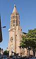
- The Notre-Dame de l'Assomption cathedral is unique by its stone construction in a place dominated by red bricks. Its construction was ordered by Louis XIV.
- The Musée Ingres is the old town hall and the residence of the bishops of Montauban built in 1664. The building houses some paintings of the famous painter Jean Auguste Dominique Ingres and some works of the sculptor Antoine Bourdelle; both artists were born in Montauban.
- The church of Saint Jacques is the only intact medieval church in Montauban.
- The Pont Vieux ("Old Bridge"), a bridge from the 14th century on the Tarn river.
Gallery
-
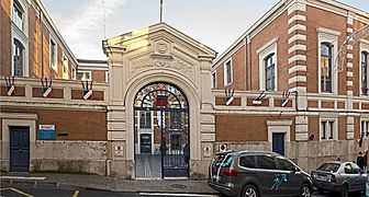
Montauban Town Hall
-
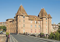
Ingres Museum
-
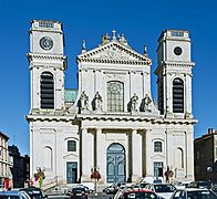
Notre Dame Cathedral


People from Montauban
- Jean Auguste Dominique Ingres (1780-1867) painter.
- Antoine Bourdelle (1861-1929), sculptor.
Sister cities
Montauban is twinned with:
 Pawhuska, United States
 Yokneam, Israel
 Khemisset, Morocco
 Kozarac, Bosnia and Herzegovina
Related pages
Images for kids
-
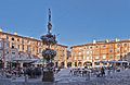
Place Nationale in Montauban
-
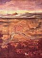
Redition of Montauban, 21 August 1629. Château de Richelieu.
-
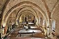
The Hall of the Black Prince (14th c.)
-
Church of Saint-Jacques
-
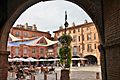
Place Nationale


.jpg)

.jpg)
See also
 In Spanish: Montauban para niños
