National Register of Historic Places listings in Alfalfa County, Oklahoma facts for kids
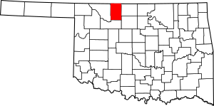
This is a list of the National Register of Historic Places listings in Alfalfa County, Oklahoma.
This is intended to be a complete list of the properties on the National Register of Historic Places in Alfalfa County, Oklahoma, United States. The locations of National Register properties for which the latitude and longitude coordinates are included below, may be seen in a map.
There are 12 properties listed on the National Register in the county.
Current listings
| Name on the Register | Image | Date listed | Location | City or town | Description | |
|---|---|---|---|---|---|---|
| 1 | Alfalfa County Courthouse |
(#84002937) |
Grand Ave. 36°45′18″N 98°21′22″W / 36.755°N 98.356111°W |
Cherokee | ||
| 2 | Aline IOOF Lodge No. 263 |
(#84002941) |
Off Main and Broadway 36°30′35″N 98°26′58″W / 36.509722°N 98.449444°W |
Aline | ||
| 3 | Carmen IOOF Home |
(#84002944) |
North of Carmen 36°35′43″N 98°27′43″W / 36.595278°N 98.461944°W |
Carmen | ||
| 4 | Carmen IOOF Lodge No. 84 |
(#84002948) |
Main and 4th St. 36°34′45″N 98°27′30″W / 36.579167°N 98.458333°W |
Carmen | ||
| 5 | Cherokee Armory |
(#88001371) |
2nd and Kansas Sts. 36°45′23″N 98°21′21″W / 36.756389°N 98.355833°W |
Cherokee | ||
| 6 | Cherokee Friends Church |
(#04001337) |
120 S. Pennsylvania 36°45′25″N 98°21′14″W / 36.756944°N 98.353889°W |
Cherokee | ||
| 7 | Cherokee IOOF Lodge No. 219 |
(#84002953) |
Grand Ave. and 2nd St. 36°45′23″N 98°21′25″W / 36.756389°N 98.356944°W |
Cherokee | ||
| 8 | Farmers' Exchange Elevator |
(#83004152) |
State Highway 45 36°31′57″N 98°09′15″W / 36.5325°N 98.154167°W |
Goltry | ||
| 9 | Farmers' Federation Elevator |
(#83004153) |
Ohio Ave. and 4th St. 36°45′23″N 98°21′34″W / 36.756389°N 98.359444°W |
Cherokee | ||
| 10 | Hotel Cherokee |
(#98000200) |
117 W. Main 36°45′29″N 98°21′28″W / 36.758056°N 98.357778°W |
Cherokee | ||
| 11 | Ingersoll Tile Elevator |
(#83004156) |
Off U.S. Route 64 36°47′49″N 98°23′20″W / 36.796944°N 98.388889°W |
Ingersoll | ||
| 12 | Sod House |
(#70000526) |
About 4 miles north of Cleo Springs 36°28′17″N 98°25′23″W / 36.471389°N 98.423056°W |
Cleo Springs |

All content from Kiddle encyclopedia articles (including the article images and facts) can be freely used under Attribution-ShareAlike license, unless stated otherwise. Cite this article:
National Register of Historic Places listings in Alfalfa County, Oklahoma Facts for Kids. Kiddle Encyclopedia.


