National Register of Historic Places listings in Washita County, Oklahoma facts for kids
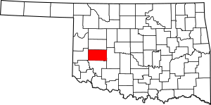
This is a list of the National Register of Historic Places listings in Washita County, Oklahoma.
This is intended to be a complete list of the properties and districts on the National Register of Historic Places in Washita County, Oklahoma, United States. The locations of National Register properties and districts for which the latitude and longitude coordinates are included below, may be seen in a map.
There are 6 properties and districts listed on the National Register in the county, including 1 National Historic Landmark.
Current listings
| Name on the Register | Image | Date listed | Location | City or town | Description | |
|---|---|---|---|---|---|---|
| 1 | Canute Service Station |
(#94001611) |
Southwestern corner of the junction of Main St. and the former U.S. Route 66 35°25′18″N 99°16′49″W / 35.421667°N 99.280278°W |
Canute | ||
| 2 | Cedar Creek District |
(#75001577) |
Address Restricted |
Carnegie | ||
| 3 | Cordell Carnegie Public Library |
(#89001966) |
105 E. 1st St. 35°17′33″N 98°59′22″W / 35.2925°N 98.989444°W |
New Cordell | ||
| 4 | McLemore Site |
(#66000636) |
Address Restricted |
Colony | ||
| 5 | New Cordell Courthouse Square Historic District |
(#98001592) |
roughly bounded by Temple, E. 2nd, Glenn English, and E. Clay Sts. 35°17′30″N 98°59′22″W / 35.291667°N 98.989444°W |
New Cordell | ||
| 6 | Washita County Courthouse |
(#84003452) |
Courthouse Square 35°17′27″N 98°59′22″W / 35.290833°N 98.989444°W |
New Cordell |
Former listing
| Name on the Register | Image | Date listed | Date removed | Location | City or town | Summary | |
|---|---|---|---|---|---|---|---|
| 1 | Seger Indian Training School |
(#71001080) |
|
Eastern edge of Colony 35°20′41″N 98°40′11″W / 35.3447°N 98.6697°W |
Colony |

All content from Kiddle encyclopedia articles (including the article images and facts) can be freely used under Attribution-ShareAlike license, unless stated otherwise. Cite this article:
National Register of Historic Places listings in Washita County, Oklahoma Facts for Kids. Kiddle Encyclopedia.


