
Panaca, Nevada facts for kids
Quick facts for kids
Panaca, Nevada
|
|
|---|---|

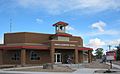
Main Street in Panaca, 2012
|
|

Panaca, Nevada
Location in Nevada

Panaca, Nevada
Location in the United States
|
|
| Country | |
| State | |
| County | Lincoln |
| Area | |
| • Total | 3.3 sq mi (8.5 km2) |
| • Land | 3.3 sq mi (8.5 km2) |
| • Water | 0 sq mi (0 km2) |
| Population
(2010)
|
|
| • Total | 963 |
| • Density | 293.4/sq mi (113.3/km2) |
| Time zone | UTC−8 (Pacific (PST)) |
| • Summer (DST) | UTC−7 (PDT) |
| ZIP code |
89042
|
| Area code(s) | 775 |
| FIPS code | 32-54200 |
| GNIS feature ID | 0847542 |
| Reference no. | 39 |
Panaca is an unincorporated town in eastern Lincoln County, Nevada, United States, on State Route 319, about 1 mile (1.6 kilometers) east of U.S. Route 93, near the border with Utah. Its elevation is 4,729 feet (1,441 meters) above sea level. As of the 2010 census, it had a population of 963. It is one of only two cities in Nevada that prohibits gambling, the other being Boulder City.
Contents
History


Panaca was southern Nevada's first permanent settlement, founded as a Mormon colony in 1864. It was originally part of Washington County, Utah, but the congressional redrawing of boundaries in 1866 shifted Panaca into Nevada. It is the only community in Nevada to be "dry" (forbidding the sale of alcoholic beverages), and the only community in Nevada, besides Boulder City, that prohibits gambling.
Coke ovens here once produced charcoal for the smelters in nearby Bullionville (now a ghost town), but the town's economy is predominantly agricultural.
The name "Panaca" comes from the Southern Paiute word Pan-nuk-ker, which means "metal, money, wealth". William Hamblin, a Mormon missionary to the Paiutes, established the Panacker Ledge (Panaca Claim) silver mine there in 1864.
Geography
According to the U.S. Census Bureau, the Panaca census-designated place has an area of 3.3 square miles (8.5 km2), all of it land. Along Nevada State Route 319 it is 19 miles (31 km) east to the Utah state line and from there another 60 miles (97 km) east to Cedar City, Utah. West from Panaca it is 1.0 mile (1.6 km) to U.S. Route 93, at which point it is 11 miles (18 km) north to Pioche and 14 miles (23 km) south to Caliente.
Attractions
Panaca is near Cathedral Gorge State Park.
The following Nevada Historical Markers have been placed in Panaca:
- Panaca (#39)
- Panaca Mercantile Store (#93)
- Panaca Spring (#160)
- Panaca Ward Chapel (#182)
Panaca celebrates Pioneer Day on the Saturday closest to July 24. Events include a 6 a.m. cannon firing, games and races, a parade, art displays, and a community dinner. This coincides with the Utah holiday commemorating the arrival of the Mormon pioneers in the Salt Lake Valley.
Images for kids
-
Panaca Elementary School, 2011

See also
 In Spanish: Panaca (Nevada) para niños
