
Reigate facts for kids
Quick facts for kids Reigate |
|
|---|---|
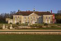
 Old Town Hall, Reigate |
|

Reigate
|
|
| Population | 21,820 (electoral definition) or 22,123 (Built-up Area) |
| OS grid reference | TQ2649 |
| • London | 19 mi (31 km) N |
| District |
|
| Shire county | |
| Region | |
| Country | England |
| Sovereign state | United Kingdom |
| Post town | REIGATE |
| Postcode district | RH2 |
| Dialling code | 01737 |
| Police | Surrey |
| Fire | Surrey |
| Ambulance | South East Coast |
| EU Parliament | South East England |
| UK Parliament |
|
Reigate ( RY-gate) is a town in Surrey, England, around 19 mi (31 km) south of central London. The settlement is first recorded in Domesday Book in 1086 as Cherchefelle but first appears with its modern name in documents dating from the 1190s. The earliest archaeological evidence for human activity is from the Paleolithic and Neolithic, and during the Roman period, tile making took place to the north east of the modern centre.
A motte-and-bailey castle was erected in Reigate in the late 11th or early 12th century. It was originally constructed of timber, but the curtain walls were rebuilt in stone about a century later. In the first half of the 13th century, an Augustinian priory was founded to the south of the modern town centre. The priory was closed during the Reformation and was rebuilt as a private residence for William Howard, the 1st Baron Howard of Effingham. The castle was abandoned around the same time and fell into disrepair.
During the medieval and early modern periods, Reigate was primarily an agricultural settlement. A weekly market began no later than 1279 and continued until 1895. Key crops included oatmeal, hops and flax, but there is no record of rye being grown in the local area. The economy initially declined in the 18th century, as new turnpike roads allowed cheaper goods made outside the town to become available, undercutting local producers. Following the arrival of the railways in the mid-19th century, Reigate began to expand and the sale of much of the priory estate in 1921 released further land for housebuilding.
Since 1974, Reigate has been one of four towns in the borough of Reigate and Banstead and is part of the London commuter belt. The borough council is based at the new town hall on Castlefield Road and Surrey County Council has its headquarters at Woodhatch Place. Much of the North Downs, to the north of Reigate, is owned by the National Trust, including Colley Hill, 722 feet (220 m) above ordnance datum (OD) and Reigate Hill 771 feet (235 m) above OD.
History

There are neolithic flint mines on the ridge of the North Downs above Reigate. Bronze Age settlement in the area is indicated by barrows on Reigate Heath. A Bronze Age spearhead was recovered on Park Hill in Reigate Priory Park. In 2004 a Roman tile kiln, dated from around AD 92 (pictured left), was recovered from the grounds of Rosehill in Doods Way. Tiles on the Rosehill site were first discovered in the 1880s. The tiles would have been used for important buildings in the area. The Rosehill find is the oldest recorded use of Reigate stone (ironstone of the Upper Greensand) for ashlar work.
Reigate was within the Reigate hundred, an Anglo-Saxon administrative division. Reigate appears in Domesday Book in 1086 as Cherchefelle, which appears to mean "the open space by the hill". It was held by William the Conqueror as successor to King Harold's widow Editha. Its Domesday assets were: 34 hides, 2 mills worth 11s 10d, 29 ploughs, 12 acres (49,000 m2) of meadow, pannage and herbage worth 183 hogs. It rendered £40 per year to its feudal system overlords.

The earlier site of the town was, at least in part, in what is now the Church Street area. Part of the site was excavated in the 1990s, and this revealed that the settlement moved during the earlier part of the 12th century when the present town was formed. William I granted the land around Reigate to one of his supporters, William de Warenne, who was created Earl of Surrey in 1088. It is believed that his son, William de Warenne, 2nd Earl of Surrey, ordered that Reigate Castle be built, although the de Warennes had their southern base at Lewes, Sussex, as well as castles in Yorkshire and Normandy. Around 1150 the Earl de Warenne laid out a new town below the castle. This town forms the basis of modern-day Reigate. Little is known of the castle, which has never been excavated on any great scale. Local legend says that prior to the signing of the Magna Carta, the rebellious barons met to hammer out the details of the document in the extensive caves beneath the castle. The story however has no truth to it. The castle later fell into decay and the remains were demolished at the end of the 17th century, though the grounds remain as a public garden, and the caves are occasionally opened for tours.
The origin of the name Reigate is uncertain, but appears to derive from Roe-deer Gate, as the town was situated near to the entrance to the de Warenne's deer park.
The medieval town is centred on a north—south road of some antiquity as it incorporates the pre-Conquest road pattern. The story of the Pilgrim's Way passing through Reigate is a myth, although in the 13th century a chapel to St Thomas was built in the town centre for use by Canterbury pilgrims.
Areas of the town have been the subject of extensive archaeological investigation. Bell Street was certainly in existence by the middle of the 12th century and Mesolithic implements have been found here. Much of High Street is of slightly later date, although there appear to have been buildings along its south side, near to the junction with Bell Street, by the 13th century at the latest. The market place was originally around Slipshoe Street, at the junction of West Street, but infilled houses encroached on it and it had been moved to the east end of the High Street by the end of the 16th century. Many of the finds from the excavations are held in the museum of the Holmesdale Natural History Club in Croydon Road.
Probably early in the 13th century Grade I listed Reigate Priory was founded for regular canons of the Order of St Augustine, although it was also a hospital under the canons. After the dissolution of the monasteries in 1535 the estate was granted by Henry VIII to William Howard, 1st Baron Howard of Effingham, who soon converted the priory buildings into a residence. The Effingham branch of the Howard family, including the Earl of Nottingham (who as Lord High Admiral commanded the force which defeated the Spanish Armada), lived there until their heirs sold it to the wealthy London brewer, John Parsons, in 1681. Remains of the former monastery buildings lie beneath the lawns to the south of the present mainly 18th-century house, which is now used as a school.
The town developed a large trade in oatmeal during the 16th century but this had ceased by about 1720. There was a noted tannery at Linkfield Street which was expanded in the 19th century. It burnt down about 1930.

The coming of the London and Brighton Railway in 1841 led to new buildings being built across the parish, resulting in a second town in the eastern fields around the railway station in an area that was previously uninhabited: this town at first had two names but since the early 20th century has been called Redhill.
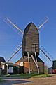
Reigate has two windmills: a post mill on Reigate Heath and a tower mill on Wray Common. In the medieval period the parish had other windmills, about a dozen animal-powered mills for oatmeal and watermills on the southern parish boundary with the Mole and Redhill Brook.
- Administrative history
The non-corporate Borough of Reigate, covering roughly the town centre, was formed in 1295. It elected two MPs until the Reform Act of 1832 when it lost one. In 1863 the whole parish was formally incorporated as a borough with Thomas Dann as its first mayor. In 1867 Redhill gained its first of two vestry committees within the parish system that occupied the east of Reigate. In 1868 Reigate borough was disenfranchised for corruption but representation was revived in the Redistribution of Seats Act in 1885. Reigate has been the term for the local MP's seat ever since. In 1974 the borough was merged with Banstead to the north.
Geography

The town centre is, save for the castle, focused on Bell Street, leading south, and a long High Street/West Street conservation area with shops, cafés, bars and restaurants. Between the streets is a Morrisons supermarket. The other central supermarket is an M&S. The swathe of land from the town southwards, including the adjacent town of Redhill, is sometimes grouped together as the Gatwick Diamond, M23 corridor or Crawley Urban Area across more than 15 miles (24 km) into West Sussex. These three largely synonymous areas are interspersed with Metropolitan Green Belt land and are used by planners to highlight connectivity to Gatwick Airport and in respect of two, the city of Brighton and Hove.
Hamlets and neighbourhoods
In the winding lanes of the south-west of Reigate post town, towards the Mole Valley, are two distinct hamlets, Skimmington and Flanchford.
Skimmington

Skimmington is a small hamlet made up of Skimmington Cottages, Heathfield Farm and Nursery, and on the C-road, Flanchford Road, Reigate Heath Golf Club House and Course. The Skimmington Castle (the most historic building, Grade II-listed) pub is by the cottages. It arguably includes most of Reigate Heath; its buildings are however predominantly south-east of Flanchford Road. Skimmington includes eight pre-historic tumuli (bowl barrows), two in one close group, several within the golf club. It is well documented by rambling groups for its serenity, hills and woods – it lies on the Greensand Way 1 mile (1.6 km) along the due west path in the south of Reigate Park or Priory Park.
Flanchford
Half of this hamlet is within the post town, being in the far south west of Reigate. It is connected by Flanchford Bridge to Little Flanchford, which is in Mole Valley, within the rural definition of Leigh which has its village centre 0.5 miles (0.80 km) south-west.
Flanchford Mill, which has as its millpond a lake at the foot of the Wallace Brook, is a Grade II* listed building dating from 1768.
South Park
This Reigate neighbourhood is south of the relatively central Priory Park (named after the town's repurposed Priory), west of Meadvale and north and north-west of Woodhatch.
Its proximity to Reigate and to the out-of-town shopping parade of Woodhatch means that South Park consists of residential and recreational green spaces. The main amenities squarely within it are South Park Sports Association and an independent Church.
Woodhatch
Woodhatch is the southern suburb of Reigate with one main curved parade of shops leading away from each side of the pre-20th century route of the London to Brighton road, which is the only road towards the south from Reigate excluding the motorway network. Reigate School was formerly called Woodhatch School. Spike Milligan lived in Orchard Way here between fighting as a young man in World War II.
Woodhatch is almost half of one of the wards of the United Kingdom, South Park and Woodhatch which has a population on 7,145.
Neighbouring settlements
 |
Mogador, Walton-on-the-Hill | Margery, Lower Kingswood | Gatton, Merstham | |
| Buckland | Redhill | |||
| Leigh | Sidlow | Earlswood, Salfords and Horley |
Culture and community

The most popular park in Reigate is the Priory Park, adjoining Reigate Priory School directly south of the High Street and west of Bell Street. It has a recreation area for smaller children as well as football fields, tennis courts, a skatepark, woodland and large Priory Pond, draining over a small weir. Priory Park also has a café set in a building named 'The Pavilion', which also houses bulletin boards for the people of Reigate.
- Representations
Reigate is the setting for the Sherlock Holmes short story The Adventure of the Reigate Squire (also known as The Adventure of the Reigate Squires and The Adventure of the Reigate Puzzle). It is one of 12 stories featured in The Memoirs of Sherlock Holmes.
Transport
Buses
Reigate is linked by a number of bus routes to Redhill and the surrounding towns and villages in east Surrey. Operators serving the town include Compass Bus, London General, Metrobus and Southdown. Routes 420 and 460 link the town to the East Surrey Hospital and the latter also runs to Gatwick Airport.
Trains
Reigate railway station is a short distance to the north of the town centre and is managed by Southern. The operator runs services to London Victoria via Redhill and East Croydon. Trains to Reading via Guildford and to Gatwick Airport via Redhill are run by Great Western Railway.
Cycle routes
The Surrey Cycleway passes through Woodhatch.
Long-distance footpaths
The Greensand Way, a 174 km (108 mi) long-distance footpath from Haslemere, Surrey to Hamstreet, Kent, passes through Reigate Park to the south of the town centre. The North Downs Way, between Farnham and Dover, runs from west to east across Colley Hill and Reigate Hill.
Places of worship
Reigate has several churches. St Mary's Parish Church (Anglican) is in Chart Lane east of the town centre with its notably old chapel of ease St Cross in the windmill on Reigate Heath (see 'Flanchford' below). Reigate Methodist Church is in the town centre. Reigate Baptist Church, Reigate Park URC, Sandcross Church, and Reigate and Redhill Community Church are further out. The Holy Family Catholic Church is the only Roman Catholic Church in Reigate. The Religious Society of Friends have a meeting house on Reigate Road (Thomas Moore House) and St Philips Church on Nutley Lane.
Sport
Association football
Reigate Priory F.C. was founded in 1870, just seven years after The Football Association was created. It has played its home games at its ground in Park Lane for the entirety of its history.
South Park F.C. was founded in 1897 and has been a member of the Redhill & District Football League since its inception. The club initially played its home games in upper South Park, between Crescent Road and Church Road. In the late 1920s, it moved to its current premises in Whitehall Lane.
Cricket
Reigate Priory Cricket Club was founded in 1852, but it is believed that the sport has been played in the town since the 1770s. The first recorded match at the club ground was in 1853, between teams from East Surrey and West Sussex.
Golf

Reigate Heath Golf Club was founded in 1895. Permission to create a 9-hole course on the heath was granted on the condition that male and female club members had equal rights.
The 18-hole Reigate Hill Golf Course was laid out as a par 72 course by the designer, David Williams.
Notable people
- John Foxe (1516/17-1587) - martyrologist, worked at Reigate Castle as tutor to the Earl of Surrey's children c. 1548-1559
- John Parsons (1639-1717) - businessman and politician, Lord Mayor of London in 1703, lived at Reigate Priory from 1681 until his death
- Ann Alexander (1774/5-1861) - banker, lived for much of her life in Reigate
- George William Alexander (1802-1890) - banker, philanthropist, son of Ann Alexander, lived at Woodhatch from 1853 until his death
- William Harrison Ainsworth (1805-1882) - historical novelist, lived at Reigate for the latter part of his life
- George Luxford (1807-1854) - botanist, lived in Reigate until 1834, published Flora of the Neighbourhood of Reigate in 1838
- Anne Manning (1807-1879) - novelist, lived at Reigate Hill from 1850 to 1878
- James Cudworth (1817-1899) - railway engineer, lived in Reigate from 1879 to 1899
- Francis Frith (1822-1898) - photographer, founded his publishing company in Reigate in 1860
- Edward Frankland (1825-1899) - organometallic chemist, set up his own independent laboratory on Reigate Hill in 1885
- Margaret Crosfield (1859-1952) - geologist, lived for the majority of her life in the town
- Fred Streeter (1879-1975) - horticulturalist and broadcaster, took his first job at Reigate Hill at the age of 12 and worked in the town until 1897
- H. M. Bateman (1887-1970) - cartoonist and illustrator, lived in Reigate for 14 years from 1918
- Cliff Michelmore (1919-2016) - broadcaster, lived in Reigate for much of his working life
- Bob Doe (1920-2010) - Battle of Britain flying ace, born in Reigate
- Ray Alan (1930-2010) - ventriloquist and writer, lived in Reigate towards the end of his life
Economy

At one time the airline Air Europe had its head office in Europe House in Reigate. Redland plc the FTSE 100 building materials company was headquartered in Reigate before its acquisition by Lafarge. The insurance company Esure is in the former Redland headquarters, and the Redland brick sculpture remains in front of the building.
Canon UK had their headquarters on the southern outskirts of Reigate. The building, opened by the Duke of Edinburgh in 2000, has won numerous design and 'green' awards.
The European headquarters of Kimberly-Clark are on London Road in the town, just south of Reigate railway station. Further along London Road towards the town centre can be found the former European headquarters of Willis Towers Watson, prior to the merger with Willis where the global and British headquarters relocated to Lime Street in London in front of which is a life-size bronze of Margot Fonteyn and a huge picturesque cedar tree.
Reigate is home to Pilgrim Brewery, which moved to its West Street address in 1984. It was the first new brewery to be established in Surrey for over a century and whose beers are brewed using the local water.
Demography and housing
In the 2011 Census, the population of the Reigate built-up area, including Woodhatch, was 22,123.
| Population | Households | % Owned outright | % Owned with a loan | hectares | |
|---|---|---|---|---|---|
| Reigate and Woodhatch | 22,123 | 9,036 | 34.5 | 38.5 | 316 |
| Regional average | 35.1 | 32.5 |
| Detached | Semi-detached | Terraced | Flats and apartments | Caravans/temporary/mobile homes/houseboats | Shared between households | |
|---|---|---|---|---|---|---|
| Reigate and Woodhatch | 2,487 | 2,853 | 1,378 | 2607 | 6 | 9 |
Across the South East Region, 28% of homes were detached houses and 22.6% were apartments.
Education
Maintained schools
There are several primary schools in Reigate. Dovers Green School and Wray Common Primary School are members of the Greensand Multi-Academy Trust. Sandcross Primary School is part of the Everychild Trust.
Reigate Parish Church Primary School was founded as the Reigate National School. Originally in West Street, it moved to London Road in 1854 and then to Blackborough Road in 1995.
Reigate Priory Junior School traces its origins to a non-denominational school, founded in 1852 in the High Street. It moved to Holmesdale Road in the 1860s and in 1993 moved to the priory, taking over the classrooms previously used by Reigate Priory Middle School. The school educates children between the ages of 7 and 11 and is due to move to new premises on Cockshott Hill in 2023.
Reigate School is a coeducational secondary school in Woodhatch. It educates children aged 11 to 16. It is part of the Greensand Multi-Academy Trust.
The Royal Alexandra and Albert School traces its origins to an orphanage for children of Dissenters, founded in Hoxton, London in 1759. The orphanage expanded rapidly and by 1769 had 28 boys and 25 girls between the ages of 6 and 9 in its care. It relocated several times during the following two centuries and, in 1943 it was renamed the Royal Alexandra School and was based on a 180-acre (73 ha) site at Duxhurst, near Salfords. A separate institution, the Royal Albert Orphan Asylum was founded near Bagshot in 1864 and admitted its first 100 children in December of that year. It was renamed the Royal Albert School in 1942. The management of the Royal Alexandra and the Royal Albert Schools was merged in 1948 and the new organisation purchased the Gatton Park estate. The following year, an Act of Parliament was passed to formally amalgamate the two institutions. Boarding accommodation was constructed at Gatton Park in 1950 and pupils were relocated from the Bagshot and Duxhurst sites in stages between 1948 and 1954. Today, the Royal Alexandra and Albert School is a coeducational maintained boarding school, educating 1125 children between the ages of 7 and 18.
Reigate College is a coeducational sixth form college for students aged 16 to 19. It opened in 1976 on Castlefield Road, to the east of the town centre. The main building, constructed in 1927, was previously occupied by the Reigate County School for Girls and was designed by the architecture firm Jarvis and Porter.
Independent schools
Micklefield School was founded in 1910 and takes its name from its original location, Micklefield House in Evesham Road. It moved to its current site in Somers Road, to the north of the town centre, in 1925. In 2021, Micklefield is a coeducational, independent day school for children aged 2 to 11.
Reigate St Mary's School was founded in 1950 as the choir school for St Mary's Church. Initially for boys only, it became coeducational in 2003, when it was made the principal feeder school for Reigate Grammar School. In 2021, Reigate St Mary's is a coeducational day school for children aged 2 to 11.

Reigate Grammar School traces its origins to 1675, when Henry Smith, an Alderman of the City of London, left a bequest of £150 for the purchase of land for a "free school". The first master, Revd John Williamson, was the vicar of Reigate and for the first two centuries, several headmasters were also parish priests. The school became a grammar school in 1861 and around this time many of the original buildings were replaced. The school was taken over by Surrey County Council under the Education Act 1944, but became independent in 1976. In the same year, girls were admitted to the sixth form and the school became fully coeducational in 1993. It merged with Reigate St Mary's Prep School and Chinthurst School in 2003 and 2017 and, as of 2021, the three school together educate around 1,500 pupils aged from 3 to 18. An international division was created in 2017, to work in partnership with the Kaiyuan Education Fund, to establish up to five schools in China.

Dunottar School was founded in 1926 and is named after Dunottar Castle in Aberdeenshire, where the Scottish Crown Jewels were kept between 1651 and 1660. In 1933, the school moved to its current site, the former High Trees house, which had been built in 1867. In 2021, Dunottar is a co-educational independent day school for children aged 11 to 18. It became part of United Learning in 2014.
Other schools
Reigate Valley College at Sidlow just south of the town is a former pupil referral unit that educates pupils that have had behavioral issues in mainstream schools. There are two special schools in the town catering for students with special educational needs, Brooklands School on Wray Park Road and Moon Hall College at Flanchford Bridge near Leigh.
Images for kids
-
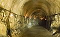
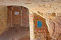
One of the tunnels excavated through the Folkestone Beds beneath Reigate Castle
-
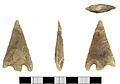
A Bronze Age barbed and tanged flint arrowhead, found in Reigate
-
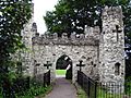
The gatehouse folly was constructed in 1777.
-
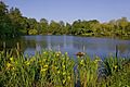
Former fish pond in Priory Park, restored in 2007
-
Reigate Priory, south elevation
-
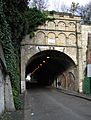
Reigate Tunnel
-
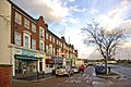
Western Parade, Woodhatch, was built in 1936.
-
Bricked-up entrance to a WW2 air raid shelter, Tunnel Road
-
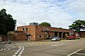
Reigate Fire Station
-
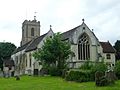
Church of St Mary Magdalene
-
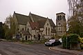
Reigate Mill Church
-
St Mark's Church
-
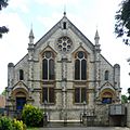
Reigate Methodist Church
-
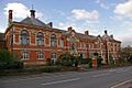
Town Hall, Castlefield Road
-
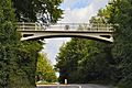
Reigate Hill Footbridge
-
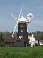
Wray Common Windmill
.jpg)
.jpg)


_(June_2013).JPG)


_(3).jpg)


See also
 In Spanish: Reigate para niños
