
Tazewell County, Illinois facts for kids
Quick facts for kids
Tazewell County
|
||
|---|---|---|

Tazewell County Courthouse in Pekin
|
||
|
||

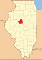
Location within the U.S. state of Illinois
|
||
 Illinois's location within the U.S. |
||
| Country | ||
| State | ||
| Founded | 1827 | |
| Named for | Littleton Waller Tazewell | |
| Seat | Pekin | |
| Largest city | Pekin | |
| Area | ||
| • Total | 658 sq mi (1,700 km2) | |
| • Land | 649 sq mi (1,680 km2) | |
| • Water | 9.0 sq mi (23 km2) 1.4% | |
| Population
(2010)
|
||
| • Total | 135,394 | |
| • Estimate
(2019)
|
131,803 | |
| • Density | 205.77/sq mi (79.45/km2) | |
| Time zone | UTC−6 (Central) | |
| • Summer (DST) | UTC−5 (CDT) | |
| Congressional districts | 17th, 18th | |

Tazewell County is a county in the U.S. state of Illinois. According to the 2010 census, it had a population of 135,394. Its county seat and largest city is Pekin. It is pronounced with a short "a", to rhyme with "razz" rather than "raze".
Tazewell County is part of the Peoria, IL Metropolitan Statistical Area. The majority of the population lives along the county's western border.
Contents
History
Tazewell County was formed out of Peoria County in 1827. The consensus appears to be that it was named in honor of Littleton Tazewell, who served in the U.S. Senate, and who became Governor of Virginia in 1834. It is, however, possible that it was named after Littleton's father, prominent Virginia politician Henry Tazewell, after whom Tazewell County, Virginia, was named.
-
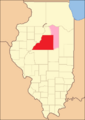
Tazewell from the time of its creation to 1829, including a large tract of unorganized territory temporarily attached to it, whose precise border was not defined.
-
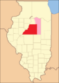
Tazewell County between 1829 and 1830: the creation of Macon County established a southern border for Tazewell's additional territory.
-
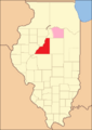
Tazewell County between 1830 and 1831: the additional territory to the east became McLean County.
-
Tazewell County between 1831 and 1841: the last of the county's additional territory became part of LaSalle County.
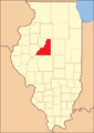
-
Tazewell County in 1841, reduced to its present borders.


Geography
According to the U.S. Census Bureau, the county has a total area of 658 square miles (1,700 km2), of which 649 square miles (1,680 km2) is land and 9.0 square miles (23 km2) (1.4%) is water.
Climate and weather
| Weather chart for Pekin, Illinois | |||||||||||||||||||||||||||||||||||||||||||||||
|---|---|---|---|---|---|---|---|---|---|---|---|---|---|---|---|---|---|---|---|---|---|---|---|---|---|---|---|---|---|---|---|---|---|---|---|---|---|---|---|---|---|---|---|---|---|---|---|
| J | F | M | A | M | J | J | A | S | O | N | D | ||||||||||||||||||||||||||||||||||||
|
1.5
31
14
|
1.7
37
20
|
2.8
49
30
|
3.6
62
40
|
4.2
73
51
|
3.8
82
60
|
4
86
65
|
3.2
84
63
|
3.1
77
54
|
2.8
64
42
|
3
49
31
|
2.4
35
20
|
||||||||||||||||||||||||||||||||||||
| temperatures in °F precipitation totals in inches source: The Weather Channel |
|||||||||||||||||||||||||||||||||||||||||||||||
|
Metric conversion
|
|||||||||||||||||||||||||||||||||||||||||||||||
In recent years, average temperatures in the county seat of Pekin have ranged from a low of 14 °F (−10 °C) in January to a high of 86 °F (30 °C) in July, although a record low of −27 °F (−33 °C) was recorded in January 1884 and a record high of 113 °F (45 °C) was recorded in July 1936. Average monthly precipitation ranged from 1.50 inches (38 mm) in January to 4.17 inches (106 mm) in May.
Adjacent counties
- Woodford County (north)
- McLean County (east)
- Logan County (south)
- Mason County (southwest)
- Fulton County (west)
- Peoria County (northwest)
Transportation
Major highways
 Interstate 74
 Interstate 155
 Interstate 474
 U.S. Highway 24
 U.S. Highway 150
 Illinois Route 8
 Illinois Route 9
 Illinois Route 29
 Illinois Route 98
 Illinois Route 116
 Illinois Route 122
Airports
The following public-use airports are located in Tazewell County:
- Pekin Municipal Airport (C15) - serves Pekin (Located by the Village of South Pekin, Illinois)
- Manito Mitchell Airport (C45) - serves Manito, a village in Mason County
Public Transportation
Bus and paratransit service in Tazewell County is provided by Peoria's “CityLink” system, operating six routes (four originating from Peoria) seven days a week.
Demographics
| Historical population | |||
|---|---|---|---|
| Census | Pop. | %± | |
| 1830 | 4,716 | — | |
| 1840 | 7,221 | 53.1% | |
| 1850 | 12,052 | 66.9% | |
| 1860 | 21,470 | 78.1% | |
| 1870 | 27,903 | 30.0% | |
| 1880 | 29,666 | 6.3% | |
| 1890 | 29,556 | −0.4% | |
| 1900 | 33,221 | 12.4% | |
| 1910 | 34,027 | 2.4% | |
| 1920 | 38,540 | 13.3% | |
| 1930 | 46,082 | 19.6% | |
| 1940 | 58,362 | 26.6% | |
| 1950 | 76,165 | 30.5% | |
| 1960 | 99,789 | 31.0% | |
| 1970 | 118,649 | 18.9% | |
| 1980 | 132,078 | 11.3% | |
| 1990 | 123,692 | −6.3% | |
| 2000 | 128,485 | 3.9% | |
| 2010 | 135,394 | 5.4% | |
| 2020 | 131,343 | −3.0% | |
| U.S. Decennial Census 1790-1960 1900-1990 1990-2000 2010-2019 |
|||
As of the 2010 United States Census, there were 135,394 people, 54,146 households, and 37,163 families living in the county. The population density was 208.6 inhabitants per square mile (80.5/km2). There were 57,516 housing units at an average density of 88.6 per square mile (34.2/km2). The racial makeup of the county was 96.2% white, 1.0% black or African American, 0.7% Asian, 0.3% American Indian, 0.5% from other races, and 1.3% from two or more races. Those of Hispanic or Latino origin made up 1.9% of the population. In terms of ancestry, 35.6% were German, 15.6% were American, 14.4% were Irish, and 12.0% were English.
Of the 54,146 households, 31.4% had children under the age of 18 living with them, 54.2% were married couples living together, 10.2% had a female householder with no husband present, 31.4% were non-families, and 26.3% of all households were made up of individuals. The average household size was 2.45 and the average family size was 2.94. The median age was 39.8 years.
The median income for a household in the county was $54,232 and the median income for a family was $66,764. Males had a median income of $50,372 versus $34,747 for females. The per capita income for the county was $27,036. About 6.3% of families and 7.9% of the population were below the poverty line, including 11.2% of those under age 18 and 4.5% of those age 65 or over.
Communities
Cities
Villages
Census-designated place
- Heritage Lake
Other unincorporated communities
Townships
Tazewell County is divided into these townships:
- Boynton
- Cincinnati
- Deer Creek
- Delavan
- Dillon
- Elm Grove
- Fondulac
- Groveland
- Hittle
- Hopedale
- Little Mackinaw
- Mackinaw
- Malone
- Morton
- Pekin
- Sand Prairie
- Spring Lake
- Tremont
- Washington
Notable people
- Charles "Buffalo" Jones, cowboy and naturalist
See also
 In Spanish: Condado de Tazewell (Illinois) para niños
