Thitu Island facts for kids
|
Native name:
Pulo ng Pag-asa
|
|
|---|---|

Thitu Island
|
|
| Geography | |
| Location | West Philippine Sea |
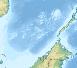
| Coordinates | 11°03′08″N 114°17′00″E / 11.05222°N 114.28333°E |
| Archipelago | Spratly Islands |
| Administration | |
| Region | Southwestern Tagalog Region |
| Province | Palawan |
| Municipality | Kalayaan |
| Demographics | |
| Population | 193 |
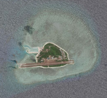
Thitu Island, also known as Pag-asa Island (Tagalog: Pulo ng Pag-asa, lit. 'Island of Hope'; Pangasinan: Ilalo, lit. 'Hope'; Hokkien Chinese: 鐵峙/铁峙/鐵堆; Pe̍h-ōe-jī: Thih-tu; literally "Iron Shoal"; Mandarin Chinese: 中業島/中业岛; pinyin: Zhōngyè Dǎo; Vietnamese: Đảo Thị Tứ), having an area of 37.2 hectares (92 acres), is the second largest of the naturally occurring Spratly Islands and the largest of the Philippine-administered islands. It lies about 500 kilometers (310 mi) west of Puerto Princesa. Its neighbors are the North Danger Reef to the north, Subi Reef to the west, and the Loaita and Tizard Banks to the south.
As the poblacion (administrative center) of the Kalayaan municipality of Palawan province in the Philippines, it also administers nearly a dozen other islets, cays and reefs in the Spratly Islands. China (PRC), Taiwan (ROC) and Vietnam also claim the island.
In 2019–20, the island's naval port and civilian-military airstrip were upgraded despite being swarmed by Chinese vessels. Pag-asa Island has a naval jetty and landing ramp, dual use military and civilian airstrip, a lighthouse, a 5-bed lying-in clinic, a communication tower powered by Smart, and a small integrated elementary and high school.
While most of the occupants of the structures in the Spratly Islands have military personnel or temporary tourists, Pag-asa Island is the only one with a permanent civilian settlement.
Contents
Etymology
The Filipino (Tagalog) name of the island is Pag-asa ("Hope"). It is also variously called in the following languages, English: Thitu Island; Mandarin simplified Chinese: 中业岛; traditional Chinese: 中業島; pinyin: Zhōngyè Dǎo; Vietnamese: Đảo Thị Tứ; Pangasinan: Ilalo, lit. 'Hope'; Hokkien Chinese: 鐵峙/铁峙/鐵堆; Pe̍h-ōe-jī: Thih-tu; literally "Iron Shoal".
Hokkien Chinese fishermen historically called the island Thih-tu (Chinese: 鐵峙/铁峙/鐵堆; Pe̍h-ōe-jī: Thih-tu; literally "Iron Shoal"; in Hokkien Min Nan pronounced). It is sometimes incorrectly referred to as "Tiezhi Island" from the Mandarin reading (Chinese: 鐵峙島/铁峙岛; pinyin: Tiězhì Dǎo; literally "Iron Shoal Island"); Tiezhi Reef (simplified Chinese: 铁峙礁; traditional Chinese: 鐵寺礁) refers to another area 7.5 km northeast of this island. The modern Mandarin Chinese name of the island was taken from one of the battleships named Chung-yeh (Chinese: 中業號; pinyin: Zhōngyè Hào), sent by the Chinese government during the Republic of China era to regain control of the island in 1946.
History
Early and colonial history
There are historical records of the island having been inhabited, at various times in history, by fishermen from Champa in present-day Vietnam and the Chinese, and during the Second World War by French Indochina and Imperial Japanese troops.
In June 1763, the British ship Earl Temple sank on the reefs of Pag-asa Island en route to Manila. Three crewmembers survived for months on the island, built a raft, and used bird feathers to make a sail. The castaways were able to reach Vietnam, later China, and from there return to England. In 1997 the shipwreck of the Earl Temple was discovered by Philippine authorities, and artifacts were recovered and are now displayed at the National Museum of the Philippines.
From 1930 to 1933, the French colonial government in French Indochina sent naval troops to the Spratlys, including Pag-asa Island. On 21 December 1933, Gouverneur M. J. Krautheimer in Cochinchina (now Vietnam) decided to annex the Spratlys to Bà Rịa Province.
Post-World War 2 history
Occupation and establishment of civilian administration by the Republic of China
After Japan surrendered to the Allies on August 15, 1945, Republic of China officials responsible for reclaiming the South China Sea Islands embarked to recover the island. The Ministry of the Interior re-erected national markers on the major islands, drew up detailed maps of them, renamed them, and published the Location Map of the South China Sea Island.
In May 1956, Tomás Cloma, a Philippine national, landed on several of the islands, claiming that he had discovered them and enjoyed the rights associated with discovery-occupation. The ROC ambassador to the Philippines immediately issued a statement stressing that the islands were ROC territory, and sent a letter of protest to Philippine Vice President and Foreign Secretary Carlos Polestico Garcia. The Philippine government stated that these were individual actions by Cloma and had nothing to do with the Philippine government.
On October 1, 1956, at Bei Zi Reef in the South China Sea (called North Danger Reef in ), two nationalist Chinese ships (called Taiwanese ships in )- namely, the Ning Yuan (寧遠) flotilla of the Republic of China Navy (ROC), containing ROC naval vessels Taihe and Yongshun - approached Cloma's expedition with the boat PMI-IV "and invited Captain Cloma (and Chief Engineer Benito Danseco, and other crew members) and aboard (the naval vessel Tai He ) for a conference. A 4-hour discussion over ownership ensued, during which Cloma was below deck, unaware that a boarding party had searched his vessel and confiscated all arms/ammunition, maps and documents. Captain Cloma protested but was treated discourteously, interrogated, and kept under detention until allowed to rejoin his boat. The next day he was again invited aboard the Chinese ship. There, even under threat to their lives, Cloma and his officers refused to recognize that Freedomland was Chinese territory and to sign a statement (signed under duress, according to Filemon Cloma's son ) that they would leave Freedomland and never come back. Cloma was forced to surrender arms for which he was given a receipt, whereupon the Chinese ship left Ciriaco. Captain Cloma found that the houses on Ciriaco and Irenea had been removed, and the buildings on Abad Santos Island burned down." (Quotation marks directly above indicated heavy paraphrasing from.)
After the Chinese government's building burning and confiscation of property, Tomas and Filemon Cloma agitated for the Government of the Philippines to support their claims to Freedomland.
On 22 May 1963, the Republic of Vietnam Navy installed a sovereignty stele on Thitu Island by crew members of the three vessels Huong Giang, Chi Lang and Ky Hoa of the South Vietnam.
Seizure by the Philippines from the Republic of China
On 18 April 1971, due to a strong typhoon hitting Pag-asa Island (Zhongye Island), the Republic of China (Taiwan) authorities ordered all the garrisons on Zhongye Island to withdraw to Taiping Island to avoid typhoons. However, after the typhoon, the Taiwan side changed its defense, transferred the original troops back to Taiwan, and then used the landing ship to transport new troops to Zhongye Island. The Philippines saw this empty space and organized the troops to land on the island occupied by Taiwan on 29 July and renamed the island "Pag-asa Island". According to the 155th page of the second episode of "The Land Salary" published by the Taiwan Marine Corps Command, the Taiwan Navy detachment that arrived at Zhongye Island on the same day found that the Philippine Marine Corps was on the island, and Captain Hao Deyun immediately ordered the command. The 76mm gun was ready to be fired. The Philippine army on the island is a huge threat to Taiwanese forces, as a result they suddenly received an order from above: no challenge, the troops changed to Taiping Island. These Taiwanese Kuomintang officers and men had to watch the Zhongye Island fall back into the hands of the Philippines.
The Philippines formally established the municipality of Kalayaan on Pag-asa island on 11 June 1978, by virtue of Presidential Decree 1596 series of 1978.
Military
The island has been occupied and administered by the Philippines since 1971.
Being the second largest of the Spratly Islands, it is tightly protected by the Philippine forces. The island's beaches have unused concrete bunkers which were built in the 1970s, a few years after the Philippine military base was established. Two-thirds of the Philippine military stationed in Philippine-occupied islands (i.e. 40 out of 60 soldiers) are assigned to the island.
See also
 In Spanish: Thitu para niños


