
Westwood, New Jersey facts for kids
Quick facts for kids
Westwood, New Jersey
|
|
|---|---|
|
Borough
|
|
| Borough of Westwood | |

Westwood Gazebo in 2014
|
|
| Motto(s):
"Hub of the Pascack Valley"
|
|

Map highlighting Westwood's location within Bergen County. Inset: Bergen County's location within New Jersey.
|
|

Census Bureau map of Westwood, New Jersey
|
|

Westwood, New Jersey
Location in Bergen County, New Jersey

Westwood, New Jersey
Location in New Jersey

Westwood, New Jersey
Location in the United States
|
|
| Country | |
| State | |
| County | |
| Incorporated | May 8, 1894 |
| Government | |
| • Type | Borough |
| • Body | Borough Council |
| Area | |
| • Total | 2.30 sq mi (5.95 km2) |
| • Land | 2.26 sq mi (5.85 km2) |
| • Water | 0.04 sq mi (0.10 km2) 1.74% |
| Area rank | 388th of 565 in state 43rd of 70 in county |
| Elevation | 66 ft (20 m) |
| Population | |
| • Total | 10,908 |
| • Estimate
(2019)
|
11,078 |
| • Rank | 224th of 566 in state 33rd of 70 in county |
| • Density | 4,814.5/sq mi (1,858.9/km2) |
| • Density rank | 115th of 566 in state 29th of 70 in county |
| Time zone | UTC−05:00 (Eastern (EST)) |
| • Summer (DST) | UTC−04:00 (Eastern (EDT)) |
| ZIP Codes |
07675, 07677
|
| Area code(s) | 201 |
| FIPS code | 3400380270 |
| GNIS feature ID | 0885442 |
Westwood (known as "The Hub of the Pascack Valley") is a borough in Bergen County, New Jersey, United States. As of the 2010 United States Census, the borough's population was 10,908, reflecting a decline of 91 (-0.8%) from the 10,999 counted in the 2000 Census, which had in turn increased by 553 (+5.3%) from the 10,446 counted in the 1990 Census. Westwood is part of the New York metropolitan area. Many of its residents regularly commute to New York City for work and leisure, many using public transportation.
Westwood was officially incorporated as a borough on May 8, 1894, from portions of Washington Township, early during the "Boroughitis" phenomenon then sweeping through Bergen County, in which 26 boroughs were formed in the county in 1894 alone. Isaac D. Bogert served as the first mayor of the Borough. In April 1909, Westwood was enlarged through the annexation of the "Old Hook" section of the borough of Emerson, and on September 24, 1957, portions of the borough were exchanged with Emerson.
Contents
History
The Lenni-Lenape Native Americans inhabited this part of the state and shared it with the transient hunters and trappers until the permanent settlers began to enter in mid-18th century. In the early 19th century, the area that would later become Westwood was within the larger political boundaries of Harrington Township, which had been established by royal charter in 1775. In 1840, the western half of Harrington Township became Washington Township, with the Hackensack River as the dividing line. Washington Township was an agrarian region with isolated farmsteads. Early families, including the Hoppers and Ackermans, are buried at the Old Hook Cemetery. An 18th-century mill was situated at the dammed stream near the intersection of today's Mill Street and First Avenue. This mill was on an important east west pathway and was the first on Musquapsink Brook. The mill was largely destroyed after a fire set by an arsonist and was dismantled in 1910.


A brief description of Washington Township written in 1844 described it as a township with six stores, four schools for 135 students, six grist mills, and 14 saw mills.
The first wave of concentrated development took place as the result of the coming of the Hackensack and New York Railroad in 1870, which followed the route of today's Pascack Valley Line. On March 5, 1870, service began between Westwood and New York City (via Jersey City and a ferry ride). Several small hotels were built near the depot, and in 1872 several houses in the latest European-influenced styles began to be built along Centre Avenue. Old maps show that growth occurred simultaneously on the land both to the east and west of the tracks. The commercial buildings included lumber and coal sheds, stores, and a bakery. There was a chapel on the corner of Third and Park Avenues. The triangular park that has played an important role as a place of community gatherings is also shown on the 1876 map.
By the 1880s, Westwood had four factories, several distilleries, a new school, a laundry and grocery store, and a new Reformed Church. In 1890, following a meeting of interested residents, those favoring the incorporation of Westwood as an independent borough conducted a petition drive. In 1894, Westwood separated from Washington Township and became an independent borough. Elected as the borough's first mayor was Isaac D. Bogert.
In 1899, a water plant constructed by Cornelius S. DeBraun provided service to the houses that had been built along the borough's newly laid streets. By the time of the 1905 New Jersey Census, there were 234 dwellings housing a population of 1,044.

Lincoln High School was constructed around the turn of the 20th century, which also saw the introduction of electricity, telephones, and automobiles to the town. Underwood & Underwood Stereoscope Company opened a plant during the first decades of the 20th century, and many congregations established their first chapels, which were replaced in later years as the congregations grew in numbers and wealth. Following a typical pattern of development throughout the 20th century, the results are a mature railroad suburb almost covered with housing units, commercial, municipal and ecclesiastical buildings. The borough still retains the open space of the triangular park at its center.
Geography
According to the United States Census Bureau, the borough had a total area of 2.314 square miles (5.992 km2), including 2.266 square miles (5.868 km2) of land and 0.048 square miles (0.124 km2) of water (2.07%).
The borough borders the Bergen County municipalities of Emerson, Hillsdale, River Vale And Washington Township.
Demographics
| Historical population | |||
|---|---|---|---|
| Census | Pop. | %± | |
| 1900 | 828 | — | |
| 1910 | 1,870 | 125.8% | |
| 1920 | 2,597 | 38.9% | |
| 1930 | 4,861 | 87.2% | |
| 1940 | 5,388 | 10.8% | |
| 1950 | 6,766 | 25.6% | |
| 1960 | 9,046 | 33.7% | |
| 1970 | 11,105 | 22.8% | |
| 1980 | 10,714 | −3.5% | |
| 1990 | 10,446 | −2.5% | |
| 2000 | 10,999 | 5.3% | |
| 2010 | 10,908 | −0.8% | |
| 2019 (est.) | 11,078 | 1.6% | |
| Population sources: 1900-1920 1900-1910 1910-1930 1900-2010 2000 2010 |
|||
2010 Census
As of the census of 2010, there were 10,908 people, 4,438 households, and 2,858 families residing in the borough. The population density was 4,814.5 per square mile (1,858.9/km2). There were 4,636 housing units at an average density of 2,046.2 per square mile (790.0/km2)*. The racial makeup of the borough was 82.98% (9,052) White, 4.62% (504) Black or African American, 0.31% (34) Native American, 7.38% (805) Asian, 0.00% (0) Pacific Islander, 2.77% (302) from other races, and 1.93% (211) from two or more races. [[Hispanic (U.S. Census)|Hispanic or Latino of any race were 11.58% (1,263) of the population.
There were 4,438 households out of which 29.1% had children under the age of 18 living with them, 52.0% were married couples living together, 8.7% had a female householder with no husband present, and 35.6% were non-families. 31.2% of all households were made up of individuals, and 14.1% had someone living alone who was 65 years of age or older. The average household size was 2.44 and the average family size was 3.11.
In the borough, the population was spread out with 21.9% under the age of 18, 6.0% from 18 to 24, 27.5% from 25 to 44, 28.0% from 45 to 64, and 16.6% who were 65 years of age or older. The median age was 41.8 years. For every 100 females there were 92.7 males. For every 100 females ages 18 and old there were 88.8 males.
The Census Bureau's 2006-2010 American Community Survey showed that (in 2010 inflation-adjusted dollars) median household income was $79,133 (with a margin of error of +/- $5,195) and the median family income was $107,966 (+/- $10,189). Males had a median income of $70,598 (+/- $14,566) versus $52,721 (+/- $10,753) for females. The per capita income for the borough was $40,839 (+/- $2,990). About 1.8% of families and 2.8% of the population were below the poverty line, including 1.9% of those under age 18 and 4.7% of those age 65 or over.
Same-sex couples headed 21 households in 2010, an increase from the 19 counted in 2000.
Annual events
Each December, Westwood holds its own holiday parade called "Home for the Holidays". Participants of the parade include the Park Ridge High School marching band, The Emerson High School marching band, and many more. The parade ends with Santa Claus riding on top of one of the fire trucks. Afterwards, there is a tree and candle lighting with hot foods included.
Downtown Westwood has a sidewalk sale held every summer. People can shop indoors or outdoors during this event. There are also fun activities and games included.
Education
Students in public school for grades kindergarten through twelfth grade attend the Westwood Regional School District, a comprehensive regional school district serving both Westwood and Washington Township. The district is the county's only regional district serving grades K-12. As of the 2018–19 school year, the district, comprised of six schools, had an enrollment of 2,814 students and 249.8 classroom teachers (on an FTE basis), for a student–teacher ratio of 11.3:1. Schools in the district (with 2018–19 enrollment data from the National Center for Education Statistics) are Berkeley Avenue Elementary School (304 students; in grades K-5), Brookside Elementary School (386; K-5), Jessie F. George Elementary School (268; K-5), Washington Elementary School (329; K-5), Westwood Regional Middle School (427; 6–7) and Westwood Regional High School (1,059; 8–12).
For the 2010–11 school year, Ketler Elementary School, which had served K-4, was shifted to become Westwood Regional Middle School for grades 6 and 7, while the other elementary schools would all serve K through 5, and the high school was shifted to grades 8-12 (from 7–12).
Public school students from the borough, and all of Bergen County, are eligible to attend the secondary education programs offered by the Bergen County Technical Schools, which include the Bergen County Academies in Hackensack, and the Bergen Tech campus in Teterboro or Paramus. The district offers programs on a shared-time or full-time basis, with admission based on a selective application process and tuition covered by the student's home school district.
Zion Lutheran School, adjacent the eponymous church founded in 1905, is a private school for students in Kindergarten through eighth grade.
Infrastructure
Transportation
_just_east_of_Westwood_Avenue_and_Washington_Avenue_in_Westwood,_Bergen_County,_New_Jersey.jpg)
Roads and highways
As of May 2010[update], the borough had a total of 39.29 miles (63.23 km) of roadways, of which 31.23 miles (50.26 km) were maintained by the municipality and 8.06 miles (12.97 km) by Bergen County.
County Route 503 and County Route 502 pass through Westwood.
Westwood can also be accessed via exits 166 and 168 on the Garden State Parkway and can also be accessed via U.S. Route 9W.
Public transportation
Westwood is served by NJ Transit at the Westwood train station, located at Broadway and Westwood Avenue. The Pascack Valley Line runs north–south to Hoboken Terminal with connections via the Secaucus Junction transfer station to New York Penn Station and to other NJ Transit rail service. Connections are available at Hoboken Terminal to other NJ Transit rail lines, the PATH train at the Hoboken PATH station, New York Waterways ferry service to the World Financial Center and other destinations and Hudson-Bergen Light Rail service.
NJ Transit bus route 165 serves Westwood with service to the Port Authority Bus Terminal in Midtown Manhattan. Westwood is the terminus for bus route 165.
Rockland Coaches offers service to the Port Authority Bus Terminal on routes 11T/11AT, 14ET and 46/47. Saddle River Tours / Ameribus provides service to the George Washington Bridge Bus Station on route 11C.
Healthcare
Pascack Valley Hospital (PVH), a 291-bed hospital located at 250 Old Hook Road, filed for bankruptcy on September 24, 2007, and shut down on November 21, 2007. On October 1, 2008, Hackensack University Medical Center opened Hackensack University Medical Center at Pascack Valley as a satellite emergency department. As of 2013, the facility has been expanded to include 128 patient beds, all in single rooms.
Notable people
People who were born in, residents of, or otherwise closely associated with Westwood include:
- Warren Bennis (1925-2014), scholar, organizational consultant and author, widely regarded as a pioneer of the contemporary field of leadership studies.
- F. Herbert Bormann (1922-2012), scientist who helped discover the ecological impact of acid rain.
- Rob Delaney (born 1984), Major League Baseball pitcher who plays for the Minnesota Twins and Tampa Bay Rays.
- Russell Dermond (1936-2015), sprint canoer who competed in the 1956 and 1960 Olympics.
- Robert Dow (born 1945), fencer who competed in the team sabre event at the 1972 Summer Olympics.
- James Gandolfini (1961-2013), actor known for playing Tony Soprano on HBO's The Sopranos.
- Jason Knapp (born 1990), professional baseball pitcher.
- Tommy La Stella (born 1989), second baseman for the Chicago Cubs.
- Robert Sean Leonard (born 1969), actor best known for his roles in House and Dead Poets Society.
- Vicente Luque (born 1991), mixed martial artist who competes in Ultimate Fighting Championship as a welterweight
- Harold Medina (1888-1990), lawyer, teacher and judge who is most noted for hearing landmark cases of conspiracy and treason.
- Carlotta Monterey (1888-1970), stage and film actress who was the third and final wife of playwright Eugene O'Neill.
- James O'Keefe (born 1984), activist-filmmaker who targeted ACORN.
- Jeff Phillips (born 1968), fitness trainer and former actor best known for his work in Guiding Light, As the World Turns and the 1996 film Independence Day.
- Elizabeth Randall, Bergen County Clerk and former member of the New Jersey General Assembly.
- Harry Randall Jr. (1927-2013), politician who served in the New Jersey General Assembly from 1962 to 1966 and from 1968 to 1970, after which he served as a member of the Bergen County Board of Chosen Freeholders.
- Katie Sagona (born 1989), model and actress who appeared in You've Got Mail and Grumpier Old Men.
- Kevin Sampson (born 1981), tackle for the Kansas City Chiefs.
- Frank Saul (1924–2019), National Basketball Association player.
- Kyle Scatliffe (born 1986), stage actor best known for playing Enjolras in the 2014 Broadway revival of Les Misérables, and Harpo in the 2015 Broadway Revival of The Color Purple.
Images for kids
-

Panoramic map of Westwood from 1924 with list of landmarks and images of several inset
-
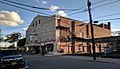
Originally opened in 1928 as the 1,275-seat Pascack Theater, the Westwood Cinema now has nine screens showing first-run movies.


See also
 In Spanish: Westwood (Nueva Jersey) para niños
