
Adams County, Illinois facts for kids
Quick facts for kids
Adams County
|
|
|---|---|

Adams County Courthouse
|
|

Location within the U.S. state of Illinois
|
|
 Illinois's location within the U.S. |
|
| Country | |
| State | |
| Founded | 1825 |
| Named for | John Quincy Adams |
| Seat | Quincy |
| Largest city | Quincy |
| Area | |
| • Total | 871 sq mi (2,260 km2) |
| • Land | 855 sq mi (2,210 km2) |
| • Water | 16 sq mi (40 km2) 1.9% |
| Population
(2020)
|
|
| • Total | 65,737 |
| • Density | 75.47/sq mi (29.140/km2) |
| Time zone | UTC−6 (Central) |
| • Summer (DST) | UTC−5 (CDT) |
| Congressional district | 18th |
Adams County is the westernmost county in the U.S. state of Illinois. As of the 2020 census, the population was 65,737. Its county seat is Quincy. Adams County is part of the Quincy, IL–MO Micropolitan Statistical Area.
Contents
History
Adams County was formed in 1825 out of Pike County. Its name is in honor of the sixth President of the United States, John Quincy Adams.
-
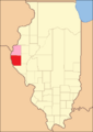
When it was created, Hancock County was temporarily attached to Adams until it could organize a county government.
-
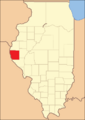
Adams County reduced to its current borders in 1829.


Geography
| Weather chart for Quincy, Illinois | |||||||||||||||||||||||||||||||||||||||||||||||
|---|---|---|---|---|---|---|---|---|---|---|---|---|---|---|---|---|---|---|---|---|---|---|---|---|---|---|---|---|---|---|---|---|---|---|---|---|---|---|---|---|---|---|---|---|---|---|---|
| J | F | M | A | M | J | J | A | S | O | N | D | ||||||||||||||||||||||||||||||||||||
|
1.4
34
16
|
1.7
40
21
|
2.9
52
30
|
3.5
65
41
|
4.6
75
51
|
3.3
84
61
|
3.9
88
66
|
3.1
86
63
|
3.5
78
55
|
2.5
66
43
|
3.1
51
33
|
2.2
38
21
|
||||||||||||||||||||||||||||||||||||
| temperatures in °F precipitation totals in inches source: The Weather Channel |
|||||||||||||||||||||||||||||||||||||||||||||||
|
Metric conversion
|
|||||||||||||||||||||||||||||||||||||||||||||||
According to the U.S. Census Bureau, the county has a total area of 871 square miles (2,260 km2), of which 855 square miles (2,210 km2) is land and 16 square miles (41 km2) (1.9%) is water.
Adjacent counties
- Hancock County - north
- Brown County - east
- Schuyler County - east
- Pike County - south
- Marion County, Missouri - west
- Lewis County, Missouri - west
Major highways
 Interstate 172
 US Route 24
 US Route 36
 Illinois Route 57
 Illinois Route 61
 Illinois Route 94
 Illinois Route 96
 Illinois Route 104
 Illinois Route 336
National protected area
Climate and weather
In recent years, average temperatures in the county seat of Quincy have ranged from a low of 16 °F (−9 °C) in January to a high of 88 °F (31 °C) in July, although a record low of −21 °F (−29 °C) was recorded in January 1979 and a record high of 105 °F (41 °C) was recorded in July 2005. Average monthly precipitation ranged from 1.36 inches (35 mm) in January to 4.61 inches (117 mm) in May.
Demographics

| Historical population | |||
|---|---|---|---|
| Census | Pop. | %± | |
| 1830 | 2,186 | — | |
| 1840 | 14,476 | 562.2% | |
| 1850 | 26,508 | 83.1% | |
| 1860 | 41,323 | 55.9% | |
| 1870 | 56,362 | 36.4% | |
| 1880 | 59,135 | 4.9% | |
| 1890 | 61,888 | 4.7% | |
| 1900 | 67,058 | 8.4% | |
| 1910 | 64,588 | −3.7% | |
| 1920 | 62,188 | −3.7% | |
| 1930 | 62,784 | 1.0% | |
| 1940 | 65,229 | 3.9% | |
| 1950 | 64,690 | −0.8% | |
| 1960 | 68,467 | 5.8% | |
| 1970 | 70,861 | 3.5% | |
| 1980 | 71,622 | 1.1% | |
| 1990 | 66,090 | −7.7% | |
| 2000 | 68,277 | 3.3% | |
| 2010 | 67,103 | −1.7% | |
| 2020 | 65,737 | −2.0% | |
| U.S. Decennial Census 1790-1960 1900-1990 1990-2000 2010-2013 |
|||
As of the 2010 United States Census, there were 67,103 people, 27,375 households, and 17,677 families residing in the county. The population density was 78.5 inhabitants per square mile (30.3/km2). There were 29,842 housing units at an average density of 34.9 per square mile (13.5/km2). The racial makeup of the county was 93.7% white, 3.5% black or African American, 0.7% Asian, 0.2% American Indian, 0.4% from other races, and 1.6% from two or more races. Those of Hispanic or Latino origin made up 1.2% of the population. In terms of ancestry, 43.5% were German, 13.1% were Irish, 10.7% were American, and 8.7% were English.
Of the 27,375 households, 29.9% had children under the age of 18 living with them, 50.0% were married couples living together, 10.7% had a female householder with no husband present, 35.4% were non-families, and 30.1% of all households were made up of individuals. The average household size was 2.37 and the average family size was 2.94. The median age was 40.7 years.
The median income for a household in the county was $43,824 and the median income for a family was $55,791. Males had a median income of $38,830 versus $29,371 for females. The per capita income for the county was $24,308. About 8.3% of families and 12.3% of the population were below the poverty line, including 17.5% of those under age 18 and 8.1% of those age 65 or over.
Attractions
- Adams County Fair [1]
- Bayview Bridge
- Burton Cave [2]
- Fall Creek Scenic Park
- Golden Windmill [3]
- John Wood Mansion
- Saukenauk Scout Reservation [4]
- Siloam Springs State Park
- Spirit Knob Winery [5]
- Villa Katharine [6]
- Wavering Park [7]
Communities

City
Villages
Unincorporated communities
Townships
Adams County is divided into twenty-three townships:
- Beverly
- Burton
- Camp Point
- Clayton
- Columbus
- Concord
- Ellington
- Fall Creek
- Gilmer
- Honey Creek
- Houston
- Keene
- Liberty
- Lima
- McKee
- Melrose
- Mendon
- Northeast
- Payson
- Quincy
- Richfield
- Riverside
- Ursa
Education
Unified school districts
- Central Community Unit School District 3
- Liberty Community Unit School District 2
- Mendon Community Unit School District 4
- Payson Community Unit School District 1
- Quincy Public School District 172
Private schools
- Blessed Sacrament Catholic School [8]
- Chaddock School [9]
- Quincy Christian School
- Quincy Notre Dame High School
- St. Dominic Catholic School [10]
- St. Francis Solanus Catholic School [11]
- St. James Lutheran School [12]
- St. Peter Catholic School [13]
Colleges and universities
- Blessing-Rieman College of Nursing
- John Wood Community College
- Quincy University
See also
 In Spanish: Condado de Adams (Illinois) para niños
