
Chino Hills, California facts for kids
Quick facts for kids
Chino Hills, California
|
||
|---|---|---|

Chino Hills, with the San Gabriel Mountains in background
|
||
|
||

Location of Chino Hills in San Bernardino County, California
|
||

Chino Hills, California
Location in the United States
|
||
| Country | United States | |
| State | California | |
| County | San Bernardino | |
| Incorporated (city) | December 1, 1991 | |
| Government | ||
| • Type | Council-Manager | |
| Area | ||
| • Total | 44.70 sq mi (115.77 km2) | |
| • Land | 44.65 sq mi (115.64 km2) | |
| • Water | 0.05 sq mi (0.12 km2) 0.15% | |
| Elevation | 860 ft (262 m) | |
| Population
(2020)
|
||
| • Total | 78,411 | |
| • Rank | 100th in California | |
| • Density | 1,756.13/sq mi (678.05/km2) | |
| Time zone | UTC-8 (Pacific) | |
| • Summer (DST) | UTC-7 (PDT) | |
| ZIP code |
91709
|
|
| Area code(s) | 909 | |
| FIPS code | 06-13214 | |
| GNIS feature IDs | 1668255, 2409454 | |

Chino Hills (Chino, Spanish for "Curly") is a city located in the southwestern corner of San Bernardino County, California, United States. The city borders Los Angeles County on its northwest side, Orange County to its south and southwest, and Riverside County to its southeast.
Contents
History
Pre-development
After the Spanish founded Mission San Gabriel in 1771, the Chino Hills was used extensively for grazing by mission cattle. During the Mexican Republic era, the hills were used as spillover grazing from such surrounding Mexican ranchos as Santa Ana del Chino and Rancho La Sierra (Yorba). After Mexico ceded California to the United States it was, and still is, a swamp and subject to flooding annually. Most historical dwellings were demolished in the rush to build. A local state monument is present in the grass lawn area of the local fire department, if one looks closely. Casa Colina, a well-known rehabilitation center now situated in Pomona California, began as a tubercular clinic in the Los Serranos sector. Similarly, the well known hospital, Loma Linda Hospital, also had its beginnings as a tubercular clinic. Sadly, most patients admitted for tuberculosis, succumbed to the illness because of the ineffectiveness of pre-antibotic treatments.
This land was sold to Richard Gird, the founder of nearby Chino subdivision and from which the town of Chino sprung in 1910. With the building of the Carbon Canyon Mineral Springs in the modern-day Sleepy Hollow region of the city and the new Los Serranos Country Club in Los Serranos, Chino Hills, California, the area became a destination for both Los Angeles tourists and bootleggers during the prohibition because of its isolation. For the same reason, Sleepy Hollow became a destination for hippies and artists during the 1960s. During the late 1980s, an incorporation effort began and in 1991, the city was incorporated with a population of 42,000.
Development
Due to its topography of rolling hills, Chino Hills was primarily rural prior to the mid-1970s; most land was utilized for equestrian purposes and for dairies, except for the multi-use purposes of the State of California, promoting jobs for your community through day labor from the Chino Institute for Men on Central Avenue. Rapid and extensive housing developments followed throughout the 1980s and early 1990s, only slowing down in recent years. Most neighborhoods are arranged in a village-type format with strategically placed shopping centers and parks designed to be within walking distance of nearby homes.
Chino Hills is home to the Vellano Country Club, a private golf course and housing development designed by golf champion Greg Norman, his first project in the Greater Los Angeles area. With home prices expected to exceed $2 million, Vellano was touted (as of 2005) as the most expensive housing development in the Inland Empire.
Chino Hills also includes the developed golf course development neighborhood of Los Serranos. Other large master-planned subdivisions without amenities include Woodview/Village Crossing, Gordon Ranch, LaBand Village, Butterfield Ranch, Rolling Ridge, Fairfield Ranch, and Payne Ranch.
Chino Hills is also the location of The Shoppes at Chino Hills. The mall features over 65 upscale stores and restaurants. The Shoppes is designed to be "Main Street Chino Hills" featuring the Chino Hills Government Center and Library in addition to retail outlets.
Chino Hills earthquake
On July 29, 2008, a 5.4 magnitude earthquake occurred at approximately 11:42:15 am PDT (18:42:15 UTC). It was the largest earthquake to affect the urbanized portion of Southern California since the 2004 Parkfield-San Bernardino earthquake. Some incidents of damage were reported, but no fatalities or severe injuries occurred as a result. The earthquake was felt as far south as San Diego and as far north as Las Vegas. The quake was reported to have interrupted a taping of the show Judge Judy, as well as a first day taping of the new show Judge Penny. The epicenter was located at the southeast portion of the Yorba Linda Fault.
Recent
Chino Hills was ranked 34th in Money magazine's "Best places to live 2012." It is also the 6th highest income place in the United States (with population 65,000 to 250,000) and was ranked as the 13th safest city in the United States in 2008 by the FBI. Chino Hills is a part of the Chino Valley.
Chino Hills’ reputation is known in the national arena as well, as it was featured on the list of 87 of America's hottest towns in the January 2004 issue of Money magazine. Chino Hills was ranked 8th on the list of “best places in the west with a population under 100,000.” The magazine reviewed a decade of data for communities with above average population growth, income, and home prices “to see where people were most willing to devote a high multiple of their annual income to live happily ever after.”
Geography
| Weather chart for Chino Hills, California | |||||||||||||||||||||||||||||||||||||||||||||||
|---|---|---|---|---|---|---|---|---|---|---|---|---|---|---|---|---|---|---|---|---|---|---|---|---|---|---|---|---|---|---|---|---|---|---|---|---|---|---|---|---|---|---|---|---|---|---|---|
| J | F | M | A | M | J | J | A | S | O | N | D | ||||||||||||||||||||||||||||||||||||
|
4
68
41
|
4.1
69
44
|
3.5
69
45
|
0.7
74
47
|
0.3
76
51
|
0.1
82
55
|
0
89
59
|
0.1
89
59
|
0.3
87
58
|
0.7
80
53
|
1.3
73
45
|
2
68
41
|
||||||||||||||||||||||||||||||||||||
| temperatures in °F precipitation totals in inches source: Weather.com / NWS |
|||||||||||||||||||||||||||||||||||||||||||||||
|
Metric conversion
|
|||||||||||||||||||||||||||||||||||||||||||||||
Physical geography
Chino Hills is located at 33°58′31″N 117°43′23″W / 33.975267°N 117.723054°W.
According to the United States Census Bureau, the city has a total area of 44.8 square miles (116 km2), much of which is undeveloped rolling hills, including the Chino Hills State Park. 44.7 square miles (116 km2) of it is land and 0.1 square miles (0.26 km2) of it (0.15%) is water.
City layout
The city of Chino Hills is bounded by the Los Angeles County cities of Pomona and Diamond Bar to the north and to the northwest, the San Bernardino County city of Chino to the east, unincorporated Riverside County near Corona to the southeast, and the Orange County cities of Brea and Yorba Linda to the west and southwest, respectively, as well as an unincorporated area of Orange County between Brea and Yorba Linda and a small unincorporated area between Yorba Linda and Anaheim commonly mistaken as part of the city of Anaheim, to the southwest and south, respectively.
The eastern border of Chino Hills roughly follows the Chino Valley Freeway (SR 71), which offers access to the Pomona Freeway (SR 60) to the north and the Riverside Freeway (SR 91) to the south. Undeveloped hills form the western border, which also serves as the San Bernardino – Orange County line. Because this area is mostly undeveloped, there is only one road directly connecting Chino Hills and Orange County, Carbon Canyon Road (SR 142), which is long, winding, and prone to landslides.
 |
Diamond Bar | Pomona | Chino | |
| Diamond Bar Brea |
Chino Eastvale |
|||
| Brea Yorba Linda |
Yorba Linda Anaheim |
Corona |
Demographics
| Historical population | |||
|---|---|---|---|
| Census | Pop. | %± | |
| 1990 | 27,608 | — | |
| 2000 | 66,787 | 141.9% | |
| 2010 | 74,799 | 12.0% | |
| 2020 | 78,411 | 4.8% | |
| U.S. Decennial Census | |||
2010
The 2010 United States Census reported that Chino Hills had a population of 74,799. The population density was 1,671.5 people per square mile (645.4/km2). The racial makeup of Chino Hills was 38,035 (50.8%) White (33.4% Non-Hispanic White), 3,415 (4.6%) African American, 379 (0.5%) Native American, 22,676 (30.3%) Asian, 115 (0.2%) Pacific Islander, 6,520 (8.7%) from other races, and 3,659 (4.9%) from two or more races. Hispanic or Latino of any race were 21,802 persons (29.1%).
The Census reported that 74,644 people (99.8% of the population) lived in households, 8 (0%) lived in non-institutionalized group quarters, and 147 (0.2%) were institutionalized.
There were 22,941 households, out of which 11,026 (48.1%) had children under the age of 18 living in them, 15,840 (69.0%) were opposite-sex married couples living together, 2,381 (10.4%) had a female householder with no husband present, 1,101 (4.8%) had a male householder with no wife present. There were 834 (3.6%) unmarried opposite-sex partnerships, and 142 (0.6%) same-sex married couples or partnerships. 2,713 households (11.8%) were made up of individuals, and 717 (3.1%) had someone living alone who was 65 years of age or older. The average household size was 3.25. There were 19,322 families (84.2% of all households); the average family size was 3.54.
The population was spread out, with 20,291 people (27.1%) under the age of 18, 7,147 people (9.6%) aged 18 to 24, 20,207 people (27.0%) aged 25 to 44, 21,889 people (29.3%) aged 45 to 64, and 5,265 people (7.0%) who were 65 years of age or older. The median age was 36.6 years. For every 100 females, there were 97.7 males. For every 100 females age 18 and over, there were 94.7 males.
There were 23,617 housing units at an average density of 527.8 per square mile (203.8/km2), of which 18,421 (80.3%) were owner-occupied, and 4,520 (19.7%) were occupied by renters. The homeowner vacancy rate was 1.0%; the rental vacancy rate was 5.4%. 61,152 people (81.8% of the population) lived in owner-occupied housing units and 13,492 people (18.0%) lived in rental housing units. The median household income was $106,099 and the mean household income was $122,788. For families, the median income was $109,106 and the mean was $127,755.
2000
As of the census of 2000, there were 66,787 people, 20,039 households, and 17,073 families residing in the city. The population density was 575.5/km2 (1,490.6/mi2). There were 20,414 housing units at an average density of 175.9/km2 (455.6/mi2). The racial makeup of the city was 56.4% White, 5.5% African American, 0.6% Native American, 22.1% Asian, 0.1% Pacific Islander, 10.6% from other races, and 4.7% from two or more races. 25.7% of the population were Hispanic or Latino of any race. The average house cost was $654,250.
There were 20,039 households, out of which 53.8% had children under the age of 18 living with them, 72.6% were married couples living together, 8.5% had a female householder with no husband present, and 14.8% were non-families. 10.8% of all households were made up of individuals, and 1.6% had someone living alone who was 65 years of age or older. The average household size was 3.33 and the average family size was 3.61. The average home price (excluding the unincorporated area of Los Serranos) was approximately $716,900, and the median home price was $659,900.
In the city, the population was spread out, with 32.9% under the age of 18, 7.4% from 18 to 24, 35.6% from 25 to 44, 19.9% from 45 to 64, and 4.2% who were 65 years of age or older. The median age was 32 years. For every 100 females, there were 98.9 males. For every 100 females age 18 and over, there were 95.1 males.
The median income for a household in the city was $83,550, and the median income for a family was $81,794. Males had a median income of $55,272 versus $38,620 for females. The per capita income for the city was $26,182. The average income for the city was $95,990. 4.1% of the population and 2.7% of families were below the poverty line. Out of the total population, 4.7% of those under the age of 18 and 3.9% of those 65 and older were living below the poverty line.
Places of worship
Nondenominational Christianity
- Calvary Chapel Chino Hills
Evangelical
- Chino Valley Community Church
Roman Catholicism
- Saint Paul the Apostle Roman Catholic Church - The largest church in the Roman Catholic Diocese of San Bernardino
The Church of Jesus Christ of Latter-day Saints
- The Church of Jesus Christ of Latter-day Saints at 3332 and 3354 Eucalyptus Avenue in Chino Hills.
Buddhism
- Buddhist Temple of Chino Hills
Hinduism
Lutheranism
- Loving Savior of the Hills Lutheran Church
Infrastructure
Transportation
Local highways
- State Route 60
- State Route 71
- State Route 91
- State Route 142
Public transportation
Chino Hills is served by Omnitrans' OmniLink demand-response service open to the general public. For $2.50 each way, one can travel throughout the city and transfer for free to the Omnitrans public bus at the Chino Hills Marketplace and the Chino Hills Civic Center. The dial-a-ride service operates five days a week, mostly during daytime hours.
Economy
Top employers
According to the city's 2020 Comprehensive Annual Financial Report, the top employers in the city are:
| # | Employer | # of Employees |
|---|---|---|
| 1 | Chino Valley Unified School District | 3,350 |
| 2 | Costco | 340 |
| 3 | Lowe's | 265 |
| 4 | Boys Republic | 264 |
| 5 | City of Chino Hills | 229 |
| 6 | Albertsons | 226 |
| 7 | Kaiser Permanente Laboratory | 220 |
| 8 | Chino Valley Fire District | 140 |
| 9 | 99 Ranch Market | 124 |
| 10 | Harkins Theaters | 123 |
Education
Chino Hills is served by the Chino Valley Unified School District.
Elementary schools
- Hidden Trails
- Country Springs
- Eagle Canyon
- Oak Ridge
- Butterfield Ranch
- Michael G. Wickman
- Chaparral
- Gerald F. Litel
- Glenmeade
- Rolling Ridge
Junior high schools
- Canyon Hills Junior High
- Robert O. Townsend Junior High
High schools
- Ruben S. Ayala High School
- Chino Hills High School
- Boys Republic - a treatment center for boys ages 12 to 18
Independent schools
- Loving Savior of the Hills
- Chino Hills Christian School
- Chino Hills Montessori School
Charter schools
- Mirus Secondary School
- Sycamore Academy of Science and Cultural Arts
Notable people
- A Static Lullaby, major label-signed post-hardcore band
- A Thorn for Every Heart, major label-signed post-hardcore band
- LaMelo Ball, point guard for the Charlotte Hornets
- Lavar Ball, American businessman and former professional football player
- LiAngelo Ball, basketball player
- Lonzo Ball, point guard for the Chicago Bulls, drafted by the Los Angeles Lakers in the 2017 NBA Draft as the Number 2 overall pick after playing his freshmen year of college basketball for UCLA
- Cory Harkey, Los Angeles Rams tight end
- Mike Harkey, former Major League pitcher and pitching coach, 1987 first-round draft pick Chicago Cubs
- Danny Lopez, Hall of Fame boxer
- Steve McQueen (1930–80), actor, spent some of his teen years at Boys Republic High School
- Ricky Minor, American Idol music director
- Mat Mladin, AMA Superbike champion
- Tracy Murray, retired NBA Champion
- Leah O'Brien-Amico, U.S. Olympic softball group gold medalist
- Tony Pedregon, NHRA Funny Car champion
- Rafael Pérez, former Los Angeles Police Department officer, convicted in relation to the Rampart scandal
- Mike Randolph, Los Angeles Galaxy soccer player
- Ron Roenicke, MLB player and manager
- Brianne Tju, actress
- Kwame Watson-Siriboe, Real Salt Lake City soccer player
- Tyler Wilson, soccer player
- Del Worsham, NHRA Top Fuel dragster driver
Images for kids
-
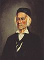
Californio land barron Antonio María Lugo was granted Rancho Santa Ana del Chino in 1841, which grew into modern Chino and Chino Hills.

See also
 In Spanish: Chino Hills para niños
