
Frenchtown, New Jersey facts for kids
Quick facts for kids
Frenchtown, New Jersey
|
|
|---|---|
|
Borough
|
|
| Borough of Frenchtown | |

Harrison Street in Frenchtown
|
|

Map of Frenchtown in Hunterdon County. Inset: Location of Hunterdon County in the State of New Jersey.
|
|

Census Bureau map of Frenchtown, New Jersey
|
|

Frenchtown, New Jersey
Location in Hunterdon County, New Jersey

Frenchtown, New Jersey
Location in New Jersey

Frenchtown, New Jersey
Location in the United States
|
|
| Country | |
| State | |
| County | |
| Incorporated | April 4, 1867 |
| Government | |
| • Type | Borough |
| • Body | Borough Council |
| Area | |
| • Total | 1.23 sq mi (3.18 km2) |
| • Land | 1.13 sq mi (2.92 km2) |
| • Water | 0.10 sq mi (0.26 km2) 8.05% |
| Area rank | 481st of 565 in state 20th of 26 in county |
| Elevation | 220 ft (70 m) |
| Population | |
| • Total | 1,373 |
| • Estimate
(2019)
|
1,351 |
| • Rank | 521st of 566 in state 21st of 26 in county |
| • Density | 1,087.2/sq mi (419.8/km2) |
| • Density rank | 371st of 566 in state 8th of 26 in county |
| Time zone | UTC−05:00 (Eastern (EST)) |
| • Summer (DST) | UTC−04:00 (Eastern (EDT)) |
| ZIP Code |
08825
|
| Area code(s) | 908 Exchange: 996 |
| FIPS code | 3401925350 |
| GNIS feature ID | 0885227 |
| Website | |
Frenchtown is a borough in Hunterdon County, New Jersey, United States. Frenchtown is located along the banks of the Delaware River on the Hunterdon Plateau thirty two miles northwest of the state capital Trenton. As of the 2010 United States Census, the borough's population was 1,373, reflecting a decline of 115 (-7.7%) from the 1,488 counted in the 2000 Census, which had in turn declined by 40 (-2.6%) from the 1,528 counted in the 1990 Census.
Contents
History
In 1757, three joint owners of a tract purchased from the West Jersey Land Society began laying out streets and building lots at Calvin's Ferry. The developing town was to be called "Alexandria" in honor of William Alexander, Lord Stirling, one of the three owners. In 1776, the three sold the settlement to Thomas Lowrey, a Flemington speculator.
In 1794, Lowrey sold the tract to Paul Henri Mallet-Prevost, a Swiss fugitive from the French Revolution. He and other early settlers were French speaking, leading some to begin calling the place "Frenchtown."
The town grew substantially in the next four decades. A trade in grain and other farm products developed. Boatmen and river men helped fuel Frenchtown's growth through their buying of cargo and food, and hiring of pilots. In the years after Henri Mallet-Prevost's death, his sons sold off portions of their property; no longer was the town privately owned.
The arrival of the Belvidere Delaware Railroad in 1853 sparked continued growth in Frenchtown. Steam-powered industry became widely developed, and by the 1860s, mills were being converted into larger factories. Around the same time, the town had three major hotels, The Lower Hotel (Present day Frenchtown Inn), The Middle Hotel (no longer existing), and the Upper Hotel (The National Hotel). In 1889, Britton Brothers Big Brick Store, which sold a variety of goods, opened on Bridge Street.
In the early 20th century, growth was spurred by the arrival of Frenchtown Porcelain Works, the establishment of the Milford plant of the Warren Paper Company, and the rise of the poultry industry.
Geography
According to the United States Census Bureau, the borough had a total area of 1.361 square miles (3.524 km2), including 1.263 square miles (3.271 km2) of land and 0.098 square miles (0.253 km2) of water (7.17%).
Frenchtown borders Kingwood Township and Alexandria Township. Frenchtown also borders the Commonwealth of Pennsylvania and is south of Milford borough.
Frenchtown Solar is a group of three photvoltaic arrays forming one of the largest solar farms in the state covering 110 acres (44.5 ha) with 68,500 solar panels and 20.1 megawatt capacity.
Demographics
| Historical population | |||
|---|---|---|---|
| Census | Pop. | %± | |
| 1870 | 912 | — | |
| 1880 | 1,039 | 13.9% | |
| 1890 | 1,023 | −1.5% | |
| 1900 | 1,029 | 0.6% | |
| 1910 | 984 | −4.4% | |
| 1920 | 1,104 | 12.2% | |
| 1930 | 1,189 | 7.7% | |
| 1940 | 1,238 | 4.1% | |
| 1950 | 1,305 | 5.4% | |
| 1960 | 1,340 | 2.7% | |
| 1970 | 1,459 | 8.9% | |
| 1980 | 1,573 | 7.8% | |
| 1990 | 1,528 | −2.9% | |
| 2000 | 1,488 | −2.6% | |
| 2010 | 1,373 | −7.7% | |
| 2019 (est.) | 1,351 | −1.6% | |
| Population sources: 1880-1920 1880-1890 1890-1910 1910-1930 1930-1990 2000 2010 |
|||
Census 2010
As of the census of 2010, there were 1,373 people, 596 households, and 366 families residing in the borough. The population density was 1,087.2 per square mile (419.8/km2). There were 656 housing units at an average density of 519.4 per square mile (200.5/km2)*. The racial makeup of the borough was 96.65% (1,327) White, 0.80% (11) Black or African American, 0.36% (5) Native American, 0.95% (13) Asian, 0.00% (0) Pacific Islander, 0.07% (1) from other races, and 1.17% (16) from two or more races. [[Hispanic (U.S. Census)|Hispanic or Latino of any race were 5.10% (70) of the population.
There were 596 households out of which 26.7% had children under the age of 18 living with them, 46.0% were married couples living together, 11.1% had a female householder with no husband present, and 38.6% were non-families. 31.4% of all households were made up of individuals, and 8.7% had someone living alone who was 65 years of age or older. The average household size was 2.27 and the average family size was 2.88.
In the borough, the population was spread out with 20.9% under the age of 18, 6.2% from 18 to 24, 27.3% from 25 to 44, 34.3% from 45 to 64, and 11.3% who were 65 years of age or older. The median age was 42.6 years. For every 100 females there were 95.6 males. For every 100 females ages 18 and old there were 95.3 males.
The Census Bureau's 2006-2010 American Community Survey showed that (in 2010 inflation-adjusted dollars) median household income was $62,574 (with a margin of error of +/- $9,339) and the median family income was $76,250 (+/- $12,807). Males had a median income of $62,500 (+/- $7,602) versus $34,886 (+/- $5,656) for females. The per capita income for the borough was $33,966 (+/- $5,364). About 4.9% of families and 8.0% of the population were below the poverty line, including 11.1% of those under age 18 and 4.3% of those age 65 or over.
Census 2000
As of the 2000 United States Census there were 1,488 people, 613 households, and 375 families residing in the borough. The population density was 1,160.7 people per square mile (448.8/km2). There were 630 housing units at an average density of 491.4 per square mile (190.0/km2). The racial makeup of the borough was 95.97% White, 0.40% African American, 0.20% Native American, 1.21% Asian, 1.34% from other races, and 0.87% from two or more races. Hispanic or Latino of any race were 2.62% of the population.
There were 613 households, out of which 30.7% had children under the age of 18 living with them, 49.9% were married couples living together, 8.5% had a female householder with no husband present, and 38.7% were non-families. 28.9% of all households were made up of individuals, and 7.8% had someone living alone who was 65 years of age or older. The average household size was 2.38 and the average family size was 2.99.
In the borough the population was spread out, with 22.5% under the age of 18, 6.5% from 18 to 24, 35.2% from 25 to 44, 25.9% from 45 to 64, and 9.8% who were 65 years of age or older. The median age was 38 years. For every 100 females, there were 94.0 males. For every 100 females age 18 and over, there were 95.4 males.
The median income for a household in the borough was $52,109, and the median income for a family was $62,132. Males had a median income of $42,321 versus $30,952 for females. The per capita income for the borough was $27,765. About 2.4% of families and 3.3% of the population were below the poverty line, including 4.0% of those under age 18 and 1.4% of those age 65 or over.
Transportation
_just_east_of_the_Uhlerstown-Frenchtown_Bridge_in_Frenchtown,_Hunterdon_County,_New_Jersey.jpg)
As of May 2010[update], the borough had a total of 10.32 miles (16.61 km) of roadways, of which 7.50 miles (12.07 km) were maintained by the municipality, 2.36 miles (3.80 km) by Hunterdon County and 0.34 miles (0.55 km) by the New Jersey Department of Transportation and 0.12 miles (0.19 km) by the Delaware River Joint Toll Bridge Commission.
Frenchtown is the northern terminus of Route 29, the western terminus of Route 12 and the southern terminus of Route 513.
The Uhlerstown–Frenchtown Bridge is a toll-free bridge over the Delaware River, owned and operated by the Delaware River Joint Toll Bridge Commission, connecting New Jersey Route 12 in Frenchtown with Pennsylvania Route 32 in Uhlerstown, located in Tinicum Township, Bucks County, Pennsylvania. Reconstructed in 1931, the bridge is a six-span Warren truss that extends 950 feet (290 m).
Education
The Frenchtown School District serves public school students in pre-kindergarten through eighth grade at Edith Ort Thomas Elementary School. As of the 2018–19 school year, the district, comprised of one school, had an enrollment of 130 students and 18.2 classroom teachers (on an FTE basis), for a student–teacher ratio of 7.1:1. In the 2016–17 school year, Frenchtown was tied for the 18th-smallest enrollment of any school district in the state, with 129 students.
Public school students in ninth through twelfth grades attend the Delaware Valley Regional High School in Frenchtown, which serves students in western Hunterdon County from Alexandria, Holland and Kingwood Townships along with the boroughs of Frenchtown and Milford. As of the 2018–19 school year, the high school had an enrollment of 721 students and 68.4 classroom teachers (on an FTE basis), for a student–teacher ratio of 10.5:1. The nine seats on the high school district's nine-member board of education are allocated based on population, with one seat allocated to Frenchtown.
Eighth grade students from all of Hunterdon County are eligible to apply to attend the high school programs offered by the Hunterdon County Vocational School District, a county-wide vocational school district that offers career and technical education at its campuses in Raritan Township and at programs sited at local high schools, with no tuition charged to students for attendance.
Notable people
People who were born in, residents of, or otherwise closely associated with Frenchtown include:
- James Agee (1909–1955), author, editor and poet who lived in Frenchtown (on Second Street in what is now the police station) with second wife Alma from 1938–1939 and wrote Let Us Now Praise Famous Men during that time.
- Elizabeth Gilbert (born 1969), author of Eat, Pray, Love.
- Shea Hembrey (born 1974), conceptual artist.
- Lois Hunt (1925–2009), soprano opera singer who toured for decades with baritone Earl Wrightson.
- Anne Kursinski (born 1959), top show jumping competitor.
- Harvey Spencer Lewis (1883–1939), Rosicrucian author, occultist and mystic.
- J. Linus McAtee (1897–1963), thoroughbred horse racing jockey.
- Barb Morrison (born 1967) songwriter and record producer.
- Billy Pauch (born 1957), race car driver.
- Anna Pump (1934–2015), chef, cookbook author, baker, and innkeeper famous for her bakery in The Hamptons, Loaves & Fishes.
- Nathanael West (1903–1940), novelist, screenwriter and satirist, author of Miss Lonelyhearts and The Day of the Locust, boarded at the Frenchtown Inn during the 1930s.
Images for kids
-
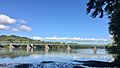
Uhlerstown–Frenchtown Bridge crossing the Delaware River
-
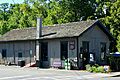
Former Frenchtown Station on the Belvidere Delaware Railroad
-
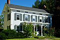
Nathaniel Shurtz house
-
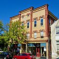
Oddfellows Building


See also
 In Spanish: Frenchtown para niños
