
Monmouth County, New Jersey facts for kids
Quick facts for kids
Monmouth County
|
|
|---|---|

The boardwalk in Asbury Park
|
|

Location within the U.S. state of New Jersey
|
|
 New Jersey's location within the U.S. |
|
| Country | |
| State | |
| Founded | 1683 |
| Named for | Monmouthshire |
| Seat | Freehold Borough |
| Largest city | Middletown Township (population) Howell Township (area) |
| Area | |
| • Total | 665.32 sq mi (1,723.2 km2) |
| • Land | 468.79 sq mi (1,214.2 km2) |
| • Water | 196.53 sq mi (509.0 km2) 29.54% |
| Population
(2020)
|
|
| • Total | 643,615 |
| • Density | 1,372.9/sq mi (530.1/km2) |
| Congressional districts | 4th, 6th |
Monmouth County is a county located on the coast of central New Jersey, in the United States within the New York metropolitan area, situated along the northern half of the Jersey Shore. As of the 2020 United States Census, Monmouth County's population was enumerated at 643,615, making it the state's fifth-most populous county, representing an increase of 13,245 (2.1%) from the 2010 Census, when the population was counted to be 630,380, in turn an increase of 15,079 from 615,301 at the 2000 Census. As of 2010, the county fell to the fifth-most populous county in the state, having been surpassed by Hudson County. Monmouth County's geographic area comprises 30% water, with a trend toward more expensive homes being constructed along the Shore, bringing rapid gentrification to the county overall.

Monmouth's county seat is Freehold Borough. The most populous place was Middletown Township, with 66,522 residents at the time of the 2010 Census, while Howell Township covered 61.21 square miles (158.5 km2), the largest total area of any municipality.
Contents
History
An English navigator, Henry Hudson, and his crew aboard the Dutch vessel Half Moon, in 1609, spotted land in what is now Monmouth County, most likely off Sandy Hook; however, some historical accounts credit this landing to present-day Keansburg. Among the first European settlers and majority landowners in the area was Richard and Penelope Stout. Penelope miraculously survived her wounds from a native attack in Sandy Hook and further lived to the age of 110. Additionally, a group of Quaker families from Long Island who settled the Monmouth Tract, an early land grant from Richard Nicolls issued in 1665. They were followed by a group of Scottish settlers who inhabited Freehold Township in about 1682–85, followed several years later by Dutch settlers. As they arrived in this area, they were greeted by Lenape Native Americans, who lived in scattered small family bands and developed a largely amicable relationship with the new arrivals. Enslaved Africans were present in the area from at least 1680, and by 1726 made up 9% of the total population of the county.
Monmouth County was established on March 7, 1683, while part of the province of East Jersey. On October 31, 1693, the county was partitioned into the townships of Freehold, Middletown and Shrewsbury. Its name may come from the Rhode Island Monmouth Society or from a suggestion from Colonel Lewis Morris that the county should be named after Monmouthshire in Wales, Great Britain. Other suggestions include that it was named for James Scott, 1st Duke of Monmouth (1649–1685), who had many allies among the East Jersey leadership. In 1714, the first county government was established.
At the June 28, 1778, Battle of Monmouth, near Freehold Township, General George Washington's soldiers battled the British under Sir Henry Clinton, in the longest land battle of the American Revolutionary War. It was at Monmouth that the tactics and training from Friedrich Wilhelm von Steuben developed at Valley Forge during the winter encampment were first implemented on a large scale.
At independence, Monmouth's population included 1,640 slaves, as well as an undetermined number of free African Americans. The number of enslaved persons fell steeply after 1820, though a small number remained until at least 1850. Monmouth's free African American population climbed from 353 in 1790 to 2,658 in 1860.
Geography
According to the 2010 Census, the county had a total area of 665.32 square miles (1,723.2 km2), including 468.79 square miles (1,214.2 km2) of land (70.5%) and 196.53 square miles (509.0 km2) of water (29.5%).
Much of Monmouth County remains flat and low-lying even far inland. However, there are some low hills in and around Holmdel Township, and one of them, Crawford Hill, the former site of a radar facility, is the county's highest point, variously listed at 380 to 391 feet (116 to 119 m) above sea level. The top portion of the hill is owned by Alcatel-Lucent and houses a research laboratory of Bell Laboratories. The northeastern portion of the county, in the Locust section of Middletown Township and the boroughs of Highlands and Atlantic Highlands, are also very hilly. The lowest point is sea level.
Along with adjacent Ocean County, Monmouth County is a mecca of boating and fishing. Its waterways include several rivers and bays that flow from the Raritan Bayshore into Raritan Bay and Lower New York Bay and into the Atlantic Ocean. The Manasquan Inlet is located in the county, which connects the Atlantic Ocean with the estuary of the Manasquan River, a bay-like body of saltwater that serves as the starting point of the Intracoastal Waterway, which attracts as many as 1,600 boats each weekend during the peak season.
Adjacent counties
The county adjoins:
- Middlesex County, New Jersey – northwest
- Ocean County, New Jersey – south
- Mercer County, New Jersey – west
- Burlington County, New Jersey – southwest
- Richmond County, New York - north
- Nassau County, New York - northeast
National protected area
Demographics
| Historical population | |||
|---|---|---|---|
| Census | Pop. | %± | |
| 1790 | 16,918 | — | |
| 1800 | 19,872 | 17.5% | |
| 1810 | 22,150 | 11.5% | |
| 1820 | 25,038 | 13.0% | |
| 1830 | 29,233 | 16.8% | |
| 1840 | 32,909 | 12.6% | |
| 1850 | 30,313 | −7.9% | |
| 1860 | 39,346 | 29.8% | |
| 1870 | 46,195 | 17.4% | |
| 1880 | 55,538 | 20.2% | |
| 1890 | 69,128 | 24.5% | |
| 1900 | 82,057 | 18.7% | |
| 1910 | 94,734 | 15.4% | |
| 1920 | 104,925 | 10.8% | |
| 1930 | 147,209 | 40.3% | |
| 1940 | 161,238 | 9.5% | |
| 1950 | 225,327 | 39.7% | |
| 1960 | 334,401 | 48.4% | |
| 1970 | 461,849 | 38.1% | |
| 1980 | 503,173 | 8.9% | |
| 1990 | 553,124 | 9.9% | |
| 2000 | 615,301 | 11.2% | |
| 2010 | 630,380 | 2.5% | |
| 2020 | 643,615 | 2.1% | |
| Historical sources: 1790-1990 1970-2010 2000 2010 2020 * = Lost territory in previous decade. |
|||
2020 census
As of the census of 2020, the county had 643,615 people, 240,377 households, and 161,545 families. The population density was 1,372.9 inhabitants per square mile (530.1/km2). There were 268,912 housing units at an average density of 573.6 per square mile (221.5/km2). The county's racial makeup was 71.6% White, 6.08% African American, 0.07% Native American, 5.6% Asian, and 3.4% from two or more races. Hispanic or Latino of any race were 12.5% of the population.
Of the 240,377 households, of which 38.8% had children under the age of 18 living with them, 55.5% were married couples living together, 25.2% had a female householder with no husband present, 14.4% had a male householder with no wife present and 32.8% were non-families. 13.6% of all households were made up of individuals, and 12.7% had someone living alone who was 65 years of age or older. The average household size was 2.55 and the average family size was 3.16.
About 21.4% of the county's population was under age 18, 8.1% was from age 18 to 24, 34.8% was from age 15 to 44, and 18.2% was age 65 or older. The median age was 43.5 years. The gender makeup of the city was 48.7% male and 51.3% female. For every 100 females, there were 95.0 males.
The county's median household income was $102,870, and the median family income was $124,778. About 6.0% of the population were below the poverty line, including 9.1% of those under age 18 and 6.4% of those age 65 or over.
2010 census
As of the census of 2010, there were 630,380 people, 233,983 households, and 163,320 families residing in the county. The population density was 1,344.7 per square mile (519.2/km2). There were 258,410 housing units at an average density of 551.2 per square mile (212.8/km2)*. The racial makeup of the county was 82.60% (520,716) White, 7.37% (46,443) Black or African American, 0.19% (1,211) Native American, 4.96% (31,258) Asian, 0.03% (211) Pacific Islander, 2.89% (18,187) from other races, and 1.96% (12,354) from two or more races. [[Hispanic (U.S. Census)|Hispanic or Latino of any race were 9.67% (60,939) of the population.
There were 233,983 households out of which 32.4% had children under the age of 18 living with them, 55.5% were married couples living together, 10.5% had a female householder with no husband present, and 30.2% were non-families. 25% of all households were made up of individuals, and 10.7% had someone living alone who was 65 years of age or older. The average household size was 2.66 and the average family size was 3.22.
In the county, the population was spread out with 23.8% under the age of 18, 7.8% from 18 to 24, 24% from 25 to 44, 30.6% from 45 to 64, and 13.8% who were 65 years of age or older. The median age was 41.3 years. For every 100 females there were 94.7 males. For every 100 females ages 18 and old there were 91.9 males.
Transportation
Roads and highways
_between_Exit_91_and_Exit_98_in_Wall_Township,_Monmouth_County,_New_Jersey.jpg)
As of May 2010[update], the county had a total of 3,354.67 miles (5,398.82 km) of roadways, of which 2,762.31 miles (4,445.51 km) are maintained by the local municipality, 360.42 miles (580.04 km) by Monmouth County and 204.89 miles (329.74 km) by the New Jersey Department of Transportation and 27.05 miles (43.53 km) by the New Jersey Turnpike Authority.
The state routes include Route 18, Route 33, Route 33 Business, Route 34, Route 35, Route 36, Route 66, Route 70, Route 71, Route 79, and Route 138. U.S. Route 9 passes through and practically bisects Monmouth, stretching through the county for more than 20 miles (32 km) from Lakewood in Ocean County in the south to Old Bridge Township in Middlesex County to the north.
Limited access roads include Interstate 195, the only interstate to pass through the county, which extends for 8.4 miles (13.5 km) from Jackson in Ocean County on the west to Wall in Monmouth County on the east. The New Jersey Turnpike (Interstate 95) just misses the county border by 0.2 miles (0.32 km) near Upper Freehold Township. The Garden State Parkway extends 26.5 miles (42.6 km) from Brick Township in Ocean County in the south to Old Bridge Township in Middlesex County to the north. The Parkway's Monmouth Service Area is located at milepost 100, between exits 98 and 100.
Public transportation


Numerous NJ Transit buses crisscross and deliver hundreds of passengers each day to northern New Jersey and New York's Port Authority Bus Terminal in Midtown Manhattan as well as the 317 bus line going into Philadelphia. Many hundreds more each day travel on NJ Transit Rail Operations' North Jersey Coast Line, which serves Penn Station in New York City, and passes through Middlesex County, entering Monmouth County at Matawan, with 14 stations covering the length of the county, connecting the New York region to Atlantic Ocean shore communities.
Municipalities

Municipalities in Monmouth County (with 2010 Census data for population, housing units and area in square miles) are listed below. Other, unincorporated communities in the county are listed next to their parent municipality. Many of these areas are census-designated places (labeled as CDPs) that have been created by the United States Census Bureau for enumeration purposes within a township, with the 2010 Census population listed. Other communities and enclaves that exist within a municipality are also listed.
| Municipality (w/ map index) |
Municipal type |
Population | Housing units |
Total area |
Water area |
Land area |
Pop. density |
Housing density |
Unincorporated communities |
|---|---|---|---|---|---|---|---|---|---|
| Aberdeen Township (50) | township | 18,210 | 7,102 | 7.77 | 2.33 | 5.45 | 3,343.0 | 1,303.8 | Cliffwood Cliffwood Beach CDP (3,194) Henningers Mills Strathmore CDP (7,258) |
| Allenhurst (14) | borough | 496 | 365 | 0.28 | 0.02 | 0.26 | 1,887.9 | 1,389.3 | |
| Allentown (38) | borough | 1,828 | 735 | 0.63 | 0.03 | 0.60 | 3,023.9 | 1,215.8 | |
| Asbury Park (11) | city | 16,116 | 8,076 | 1.60 | 0.18 | 1.42 | 11,319.5 | 5,672.4 | |
| Atlantic Highlands (29) | borough | 4,385 | 2,002 | 4.56 | 3.27 | 1.29 | 3,401.2 | 1,552.9 | Hilton Stone Church |
| Avon-by-the-Sea (8) | borough | 1,901 | 1,321 | 0.54 | 0.12 | 0.43 | 4,459.1 | 3,098.6 | |
| Belmar (7) | borough | 5,794 | 3,931 | 1.65 | 0.60 | 1.05 | 5,544.0 | 3,761.4 | |
| Bradley Beach (10) | borough | 4,298 | 3,180 | 0.63 | 0.02 | 0.61 | 7,023.6 | 5,196.6 | |
| Brielle (1) | borough | 4,774 | 2,034 | 2.37 | 0.62 | 1.76 | 2,717.5 | 1,157.8 | Manasquan Park |
| Colts Neck Township (47) | township | 10,142 | 3,735 | 31.79 | 1.06 | 30.73 | 330.0 | 121.5 | Bucks Mill Colonial Terrace Cooks Mills Montrose Phalanx Scobeyville Vanderburg |
| Deal (15) | borough | 750 | 926 | 1.32 | 0.08 | 1.24 | 604.8 | 746.7 | |
| Eatontown (24) | borough | 12,709 | 5,723 | 5.88 | 0.05 | 5.83 | 2,181.5 | 982.3 | |
| Englishtown (36) | borough | 1,847 | 647 | 0.59 | 0.02 | 0.57 | 3,245.7 | 1,137.0 | |
| Fair Haven (20) | borough | 6,121 | 2,065 | 2.11 | 0.51 | 1.60 | 3,832.5 | 1,292.9 | |
| Farmingdale (34) | borough | 1,329 | 578 | 0.52 | 0.00 | 0.52 | 2,547.7 | 1,108.0 | |
| Freehold Borough (35) | borough | 12,052 | 4,249 | 1.95 | 0.00 | 1.95 | 6,180.8 | 2,179.1 | |
| Freehold Township (42) | township | 36,184 | 13,140 | 38.73 | 0.22 | 38.50 | 939.8 | 341.3 | Burlington Heights East Freehold CDP (4,894) Georgia Orchard Estates Siloam Smithburg Stonehurst East Stonehurst West West Freehold CDP (13,613) |
| Hazlet Township (53) | township | 20,334 | 7,417 | 5.67 | 0.12 | 5.56 | 3,659.4 | 1,334.8 | Centerville Mechanicsville North Centerville Tiltons Corner Van Marters Corner West Keansburg |
| Highlands (28) | borough | 5,005 | 3,146 | 1.37 | 0.60 | 0.77 | 6,522.8 | 4,100.1 | Waterwitch |
| Holmdel Township (51) | township | 16,773 | 5,792 | 18.11 | 0.22 | 17.90 | 937.3 | 323.7 | Centerville Crawford Corners Everett Morrells Corner Pleasant Valley Crossroads |
| Howell Township (43) | township | 51,075 | 17,979 | 61.21 | 0.65 | 60.56 | 843.4 | 296.9 | Adelphia Ardena Ardmore Estates Bergerville Candlewood Collingwood Park Fairfield Fort Plains Freewood Acres Jerseyville Lake Club Land of Pines Larrabees Lower Squankum Matthews Maxim Oak Glen Parkway Pines Ramtown CDP (6,242) Salem Hill Shacks Corner Southard Squankum West Farms Winston Park Wyckoff Mills |
| Interlaken (13) | borough | 820 | 393 | 0.38 | 0.05 | 0.33 | 2,482.3 | 1,189.7 | |
| Keansburg (30) | borough | 10,105 | 4,318 | 16.79 | 15.72 | 1.07 | 9,452.3 | 4,039.1 | Tiltons Corner |
| Keyport (32) | borough | 7,240 | 3,272 | 1.47 | 0.07 | 1.40 | 5,188.4 | 2,344.8 | |
| Lake Como (6) | borough | 1,759 | 1,115 | 0.27 | 0.01 | 0.25 | 6,943.6 | 4,401.4 | |
| Little Silver (21) | borough | 5,950 | 2,278 | 3.32 | 0.61 | 2.71 | 2,197.3 | 841.3 | Little Silver Point |
| Loch Arbour (12) | village | 194 | 159 | 0.14 | 0.04 | 0.10 | 1,928.2 | 1,580.4 | |
| Long Branch (16) | city | 30,719 | 14,170 | 6.28 | 1.01 | 5.27 | 5,824.4 | 2,686.7 | Branchport East Long Branch Elberon North Long Branch Pier Village West End |
| Manalapan Township (41) | township | 38,872 | 13,735 | 30.84 | 0.23 | 30.61 | 1,270.0 | 448.8 | Clarks Mills Elton Gordons Corner Lafayette Mills Millhurst Monmouth Heights Oakland Mills Smithburg Taylors Mills Tennent Whittier Oaks Yorketown CDP (6,535) |
| Manasquan (2) | borough | 5,897 | 3,500 | 2.53 | 1.15 | 1.38 | 4,263.0 | 2,530.2 | |
| Marlboro Township (49) | township | 40,191 | 13,436 | 30.47 | 0.11 | 30.36 | 1,323.7 | 442.5 | Beacon Hill Bradevelt Claytons Corner Henningers Mills Herberts Corner Hillsdale Marlboro Monmouth Heights Montrose Morganville CDP (5,040) Mount Pleasant Pleasant Valley Robertsville CDP (11,297) Smocks Corner Spring Valley Wickatunk |
| Matawan (33) | borough | 8,810 | 3,606 | 2.40 | 0.14 | 2.26 | 3,896.6 | 1,594.9 | Freneau |
| Middletown Township (52) | township | 66,522 | 24,959 | 58.73 | 17.75 | 40.99 | 1,622.9 | 608.9 | Belford CDP (1,768) Chapel Hill East Keansburg Everett Fairview CDP (3,806) Harmony Hendrickson Corners Holland Leonardo CDP (2,757) Leonardville Lincroft CDP (6,135) Locust Monmouth Hills Navesink CDP (2,020) New Monmouth (28,689) North Middletown CDP (3,295) Oak Hill Philips Mills Port Monmouth CDP (3,818) Red Hill River Plaza Stone Church Tiltons Corner Town Brook |
| Millstone Township (40) | township | 10,566 | 3,434 | 37.27 | 0.68 | 36.59 | 288.8 | 93.9 | Bairdsville Bergen Mills Carrs Corner Carrs Tavern Charleston Springs Clarksburg Ely Elys Corner Fair Play Holmeson Perrineville Smithburg Stone Tavern Sweetman |
| Monmouth Beach (17) | borough | 3,279 | 1,981 | 2.07 | 0.99 | 1.08 | 3,049.5 | 1,842.4 | Galilee |
| Neptune Township (45) | township | 27,935 | 12,991 | 8.67 | 0.49 | 8.18 | 3,414.3 | 1,587.8 | Bradley Park Green Grove Hamilton Ocean Grove CDP (3,342) Shark River Hills CDP (3,697) West Grove |
| Neptune City (9) | borough | 4,869 | 2,312 | 0.95 | 0.00 | 0.95 | 5,105.0 | 2,424.0 | |
| Ocean Township (46) | township | 27,291 | 11,541 | 11.00 | 0.12 | 10.88 | 2,509.1 | 1,061.1 | Cold Indian Springs Deal Park Dogs Corners Elberon Park Green Grove Oakhurst CDP (3,995) Oakhurst Manor Wanamassa CDP (4,532) Wayside Wertheins Corner West Allenhurst (1,934) West Deal |
| Oceanport (22) | borough | 5,832 | 2,390 | 3.80 | 0.62 | 3.18 | 1,833.7 | 751.5 | Port-au-peck Sands Point |
| Red Bank (26) | borough | 12,206 | 5,381 | 2.16 | 0.42 | 1.74 | 7,019.1 | 3,094.4 | |
| Roosevelt (37) | borough | 882 | 327 | 1.92 | 0.01 | 1.91 | 461.8 | 171.2 | |
| Rumson (19) | borough | 7,122 | 2,585 | 7.12 | 2.06 | 5.06 | 1,408.0 | 511.0 | Oceanic Waterloo |
| Sea Bright (18) | borough | 1,412 | 1,211 | 1.29 | 0.56 | 0.73 | 1,935.5 | 1,659.9 | Low Moor Navesink Beach Normandie |
| Sea Girt (3) | borough | 1,828 | 1,291 | 1.45 | 0.39 | 1.06 | 1,729.6 | 1,221.5 | |
| Shrewsbury Borough (25) | borough | 3,809 | 1,310 | 2.20 | 0.03 | 2.17 | 1,757.2 | 604.4 | |
| Shrewsbury Township (48) | township | 1,141 | 648 | 0.10 | 0.00 | 0.10 | 10,877.7 | 6,177.7 | |
| Spring Lake (5) | borough | 2,993 | 2,048 | 1.73 | 0.40 | 1.33 | 2,250.8 | 1,540.2 | North Spring Lake |
| Spring Lake Heights (4) | borough | 4,713 | 2,972 | 1.31 | 0.03 | 1.28 | 3,671.3 | 2,315.1 | Villa Park |
| Tinton Falls (27) | borough | 17,892 | 8,766 | 15.62 | 0.14 | 15.49 | 1,155.3 | 566.0 | Green Grove Hockhockson Macedonia Pine Brook Reevytown Wayside West Shrewsbury Wileys Corner |
| Union Beach (31) | borough | 6,245 | 2,269 | 1.89 | 0.09 | 1.80 | 3,461.5 | 1,257.7 | Natco Van Marters Corner |
| Upper Freehold Township (39) | township | 6,902 | 2,458 | 47.23 | 0.82 | 46.42 | 148.7 | 53.0 | Arneytown Cooleys Corner Cream Ridge Ellisdale Emleys Hill Homes Mills Hornerstown Imlaystown Kirbys Mills Nelsonville New Canton New Sharon Polhemustown Pullentown Red Valley Robinsville Sharon Shrewsbury Spring Mill Walnford Wrightsville |
| Wall Township (44) | township | 26,164 | 10,883 | 31.74 | 1.06 | 30.67 | 853.0 | 354.8 | Algers Mills Allaire Allenwood CDP (925) Baileys Corner Blansingburg Carmerville Collingwood Park Glendola New Bedford Osbornes Mills Remsen Mills Sterling Woods West Belmar CDP (2,493) |
| West Long Branch (23) | borough | 8,097 | 2,528 | 2.89 | 0.04 | 2.86 | 2,832.9 | 884.5 | |
| Monmouth County | county | 630,380 | 258,410 | 665.32 | 196.53 | 468.79 | 1,344.7 | 551.2 |
Climate and weather
| Weather chart for Freehold Borough, New Jersey | |||||||||||||||||||||||||||||||||||||||||||||||
|---|---|---|---|---|---|---|---|---|---|---|---|---|---|---|---|---|---|---|---|---|---|---|---|---|---|---|---|---|---|---|---|---|---|---|---|---|---|---|---|---|---|---|---|---|---|---|---|
| J | F | M | A | M | J | J | A | S | O | N | D | ||||||||||||||||||||||||||||||||||||
|
3.6
39
22
|
2.9
43
24
|
4.1
51
30
|
4.2
62
40
|
4.1
72
50
|
4.4
81
60
|
5
86
65
|
4.1
84
64
|
4.5
77
55
|
3.8
66
43
|
3.8
55
36
|
4
44
27
|
||||||||||||||||||||||||||||||||||||
| temperatures in °F precipitation totals in inches source: The Weather Channel |
|||||||||||||||||||||||||||||||||||||||||||||||
|
Metric conversion
|
|||||||||||||||||||||||||||||||||||||||||||||||
Monmouth County has a humid subtropical climate. In recent years, average temperatures in the county seat of Freehold Borough have ranged from a low of 22 °F (−6 °C) in January to a high of 86 °F (30 °C) in July, although a record low of −13 °F (−25 °C) was recorded in January 1984 and a record high of 106 °F (41 °C) was recorded in July 2011. Average monthly precipitation ranged from 2.98 inches (76 mm) in February to 5.08 inches (129 mm) in July.
On October 29, 2012, Hurricane Sandy caused catastrophic damage to coastal areas of Monmouth County. As Sandy's surge arrived in Monmouth County, flood levels of 13.31 feet (4.06 m) above normal were measured at Sandy Hook shortly before the destruction of the tidal station, breaking all previous local records. The surge caused waves as high as 32.5 feet (9.9 m), measured where the Sandy Hook Bay meets the New York Bay.
Economy
Housing expense
In 2015, the county had a per capita personal income of $69,410, the fifth-highest in New Jersey and ranked 74th of 3,113 counties in the United States. Monmouth County ranked 38th among the highest-income counties in the United States as of 2011, placing it among the top 1.2% of counties by wealth. As of 2009, it was ranked 56th in the United States by personal per-capita income.
Gentrification


Hurricane Sandy in 2012 devastated much of the northern part of the Jersey Shore, particularly in Monmouth County. This necessitated the demolition and rebuilding of entire neighborhoods. Some were rebuilt to a higher economic level; this process of climate gentrification is rapidly escalating property values and transforming many communities along the Shore. Many houses have become vacation homes for the New York financial community, akin to shoreline communities on Long Island like the Gold Coast and The Hamptons.
Telecommunications and high technology
The Bell Labs Holmdel Complex has been the site of many innovations in telecommunications and is experiencing a renaissance as a business incubator for high-tech startup companies. Today Verizon Wireless, AT&T Communications, Vonage, Avaya, and Bell Labs are located in the region.
Commerce


The county has been a commercial hub for the state and the larger northeastern United States for years. This is due to the county's location on the Jersey Shore, which attracts residents from North and South Jersey, along with the nearby states of New York, Pennsylvania, Connecticut, Delaware, and Maryland during the summer months. The region also boasts year-round attractions, such as hayrides, wine tasting, and apple picking during the autumn months. The county also features five major shopping malls:
- Freehold Raceway Mall
- Monmouth Mall
- Pier Village
- The Grove at Shrewsbury
- Jersey Shore Premium Outlets
Education

Monmouth University is a four-year private university located in West Long Branch that was founded in 1933 as Monmouth Junior College.
Brookdale Community College is the two-year community college for Monmouth County, one of a network of 19 county colleges statewide. The school is located in the Lincroft section of Middletown Township, having been founded in 1967.

Rutgers University has a partnership with Brookdale which offers bachelor's degree completion programs at Brookdale's Freehold campus.
In addition to multiple public high schools, parochial schools in Monmouth County include St. Rose High School, Red Bank Catholic High School, Christian Brothers Academy, St. John Vianney High School, and Mater Dei High School, which operate under the auspices of the Roman Catholic Diocese of Trenton. A secular private school, Ranney School, is also located in the county.
The county has an extensive vocational high school program, known as the Monmouth County Vocational School District, including five magnet schools:
- Academy of Allied Health & Science (Allied) in Neptune Township
- Biotechnology High School (BioTech) in Freehold Township
- Communications High School (Communications, CHS) in Wall Township
- High Technology High School (High Tech) in Lincroft (located on the Brookdale Community College campus)
- Marine Academy of Science and Technology (MAST) in Sandy Hook
Images for kids
-
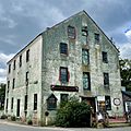
The Allentown Mill in Allentown
-

The Battle of Monmouth was waged on June 28, 1778
-
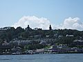
The historic Navesink Twin Lights is located on the Navesink Highlands in Highlands, one of the highest points in Monmouth County and constitute among the highest headlands along the United States east coast south of Maine
-
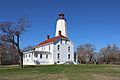
Sandy Hook Lighthouse on Sandy Hook, the oldest operating lighthouse in the United States
-
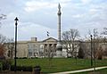
Monmouth County Courthouse with greenspace and monument dedicated to the Battle of Monmouth
-

Manasquan Reservoir on a calm afternoon in Howell Township


See also
 In Spanish: Condado de Monmouth para niños
