
Mercer County, New Jersey facts for kids
Quick facts for kids
Mercer County
|
|||
|---|---|---|---|

The New Jersey State House and its golden dome at Trenton in 2006.
|
|||
|
|||
| Nickname(s):
The Capital County
|
|||

Location within the U.S. state of New Jersey
|
|||
 New Jersey's location within the U.S. |
|||
| Country | |||
| State | |||
| Founded | 1838 | ||
| Named for | Continental Army General Hugh Mercer | ||
| Seat | Trenton | ||
| Largest municipality | Hamilton Township (population) Hopewell Township (area) |
||
| Area | |||
| • Total | 228.89 sq mi (592.8 km2) | ||
| • Land | 224.56 sq mi (581.6 km2) | ||
| • Water | 4.33 sq mi (11.2 km2) 1.89% | ||
| Population
(2020)
|
|||
| • Total | 387,340 | ||
| • Density | 1,724.9/sq mi (666.0/km2) | ||
| Congressional districts | 4th, 12th | ||


Mercer County is a county located in the U.S. state of New Jersey. Its county seat is Trenton, also the state capital, prompting the nickname The Capital County. Mercer County alone constitutes the Trenton–Princeton Metropolitan Statistical Area and is considered part of the New York Combined Statistical Area by the United States Census Bureau, but also directly borders the Philadelphia metropolitan area and is included within the Federal Communications Commission's Philadelphia Designated Market Area. As of the 2020 United States Census, Mercer County's population was 387,340, making it the state's 12th-most populous county, an increase of 20,827 (5.7%) enumerated at the 2010 U.S. Census, when its population was enumerated at 366,513, in turn an increase of 15,752 (4.5%) from the 350,761 counted at the 2000 Census, retaining its position as the 12th-most populous county in the state.
The county was formed by an act of the New Jersey Legislature on February 22, 1838, from portions of Burlington County (including Nottingham Township), Hunterdon County (including Ewing Township, Lawrence Township, Trenton and portions of Hopewell Township), and Middlesex County (including West Windsor Township and portions of East Windsor Township). The former Keith Line bisects the county and is the boundary between municipalities that previously had been separated into West Jersey and East Jersey. It was named for Continental Army General Hugh Mercer, who died as a result of wounds received at the Battle of Princeton on January 3, 1777. The Mercer Oak, against which the dying general rested as his men continued to fight, appears on the county seal and stood for 250 years until it collapsed in 2000.
Mercer County is home to Princeton University, Princeton Theological Seminary, the Institute for Advanced Study, Rider University, Westminster Choir College, The College of New Jersey, Thomas Edison State University and Mercer County Community College. Trenton–Mercer Airport, in Ewing Township, is a commercial and corporate aviation airport serving Mercer County and its surrounding vicinity. The official residence of the governor of New Jersey, known as Drumthwacket, is located in Princeton, and is listed on both the U.S. National Register of Historic Places and the New Jersey Register of Historic Places.
Contents
History

Founded February 22, 1838, from portions of surrounding counties, Mercer County has a historical impact that reaches back to the pivotal battles of the American Revolutionary War. On the night of December 25–26, 1776, General George Washington led American forces across the Delaware River to attack the Hessian barracks in Trenton on the morning of December 26. Following the battle, Washington crossed back to Pennsylvania. He crossed a third time in a surprise attack on the forces of General Charles Cornwallis at the Second Battle of Trenton on January 2, 1777, and at the Battle of Princeton on January 3. The successful attacks built morale among the pro-independence colonists.
Mercer County has the distinction of being the famed landing spot for a fictional Martian invasion of the United States. In 1938, in what has become one of the most famous American radio plays of all time, Orson Welles acted out his The War of the Worlds invasion. His imaginary aliens first "landed" at what is now West Windsor Township. A commemorative monument is erected at Grover's Mill park.
There were 27 Mercer County residents killed during the September 11, 2001 terrorist attacks in Lower Manhattan. A 10-foot (3.0 m) long steel beam weighing one ton was given to the county by the Port Authority of New York and New Jersey in March 2011 and is now displayed at Mercer County Park.
Geography
According to the 2010 Census, the county had a total area of 228.89 square miles (592.8 km2), including 224.56 square miles (581.6 km2) of land (98.1%) and 4.33 square miles (11.2 km2) of water (1.9%).
The county is generally flat and low-lying on the inner coastal plain with a few hills closer to the Delaware River. Baldpate Mountain, near Pennington, is the highest hill, at 480 feet (150 m) above sea level. The lowest point is at sea level along the Delaware.
Adjacent counties
- Somerset County, New Jersey – north
- Middlesex County, New Jersey – northeast
- Monmouth County, New Jersey – east
- Burlington County, New Jersey – south
- Bucks County, Pennsylvania – west
- Hunterdon County, New Jersey – northwest
Demographics
| Historical population | |||
|---|---|---|---|
| Census | Pop. | %± | |
| 1840 | 21,502 | — | |
| 1850 | 27,992 | 30.2% | |
| 1860 | 37,419 | 33.7% | |
| 1870 | 46,386 | 24.0% | |
| 1880 | 58,061 | 25.2% | |
| 1890 | 79,978 | 37.7% | |
| 1900 | 95,365 | 19.2% | |
| 1910 | 125,657 | 31.8% | |
| 1920 | 159,881 | 27.2% | |
| 1930 | 187,143 | 17.1% | |
| 1940 | 197,318 | 5.4% | |
| 1950 | 229,781 | 16.5% | |
| 1960 | 266,392 | 15.9% | |
| 1970 | 304,116 | 14.2% | |
| 1980 | 307,863 | 1.2% | |
| 1990 | 325,824 | 5.8% | |
| 2000 | 350,761 | 7.7% | |
| 2010 | 366,513 | 4.5% | |
| 2016 (est.) | 371,023 | 1.2% | |
| Historical sources: 1790-1990 1970-2010 2000 2010 |
|||
Census 2010
As of the census of 2010, there were 366,513 people, 133,155 households, and 89,480 families residing in the county. The population density was 1,632.2 per square mile (630.2/km2). There were 143,169 housing units at an average density of 637.6 per square mile (246.2/km2)*. The racial makeup of the county was 61.39% (225,011) White, 20.28% (74,318) Black or African American, 0.33% (1,194) Native American, 8.94% (32,752) Asian, 0.08% (295) Pacific Islander, 6.24% (22,856) from other races, and 2.75% (10,087) from two or more races. [[Hispanic (U.S. Census)|Hispanic or Latino of any race were 15.09% (55,318) of the population.
There were 133,155 households out of which 31.4% had children under the age of 18 living with them, 48.2% were married couples living together, 14.2% had a female householder with no husband present, and 32.8% were non-families. 26.9% of all households were made up of individuals, and 10.1% had someone living alone who was 65 years of age or older. The average household size was 2.61 and the average family size was 3.16.
In the county, the population was spread out with 22.6% under the age of 18, 10.9% from 18 to 24, 26.9% from 25 to 44, 26.9% from 45 to 64, and 12.6% who were 65 years of age or older. The median age was 37.8 years. For every 100 females there were 95.5 males. For every 100 females ages 18 and old there were 93 males.
Census 2000

As of the 2000 United States Census there were 350,761 people, 125,807 households, and 86,303 families residing in the county. The population density was 1,552 people per square mile (599/km²). There were 133,280 housing units at an average density of 590 per square mile (228/km²). The racial makeup of the county was 68.48% White, 19.81% Black or African American, 0.20% Native American, 4.94% Asian, 0.10% Pacific Islander, 4.29% from other races, and 2.17% from two or more races. 9.66% of the population were Hispanic or Latino of any race. Among those residents listing their ancestry, 15.4% of residents indicated that they were of Italian, 13.1% Irish, 11.8% German, 8.0% Polish and 8.0% English ancestry according to Census 2000.
There were 125,807 households out of which 32.80% had children under the age of 18 living with them, 50.6% were married couples living together, 13.8% had a female householder with no husband present, and 31.4% were non-families. 25.6% of all households were made up of individuals and 9.9% had someone living alone who was 65 years of age or older. The average household size was 2.62 and the average family size was 3.16.
In the county, the population was spread out with 24.00% under the age of 18, 10.20% from 18 to 24, 30.60% from 25 to 44, 22.50% from 45 to 64, and 12.60% who were 65 years of age or older. The median age was 36 years. For every 100 females there were 94.90 males. For every 100 females age 18 and over, there were 92.00 males.
The median income for a household in the county was $56,613, and the median income for a family was $68,494. Males had a median income of $47,444 versus $34,788 for females. The per capita income for the county was $27,914. About 5.9% of families and 8.6% of the population were below the poverty line, including 10.6% of those under age 18 and 8.4% of those age 65 or over.
Transportation


Roads and highways
Mercer County has county routes, state routes, U.S. Routes and Interstates that all pass through. As of 2010[update], the county had a total of 1,524.30 miles (2,453.12 km) of roadways, of which 1,216.48 miles (1,957.73 km) were maintained by the local municipality, 175.80 miles (282.92 km) by Mercer County, 118.99 miles (191.50 km) by the New Jersey Department of Transportation, 1.19 miles (1.92 km) by the Delaware River Joint Toll Bridge Commission and 12.43 miles (20.00 km) by the New Jersey Turnpike Authority.
The county roads that traverse through are County Route 518 (only in the Hopewells), County Route 524, County Route 526, County Route 533, County Route 535, County Route 539, County Route 546, County Route 569, County Route 571 and County Route 583.
The state routes that pass through Mercer are Route 27 (only in Princeton), Route 29, Route 31, Route 33, Route 129, and Route 133 (only in East Windsor). There are three US Routes that pass through Mercer County: U.S. Route 1 (which bisects the county), U.S. Route 130 and U.S. Route 206.
Mercer County houses a few limited access roads, such as Interstate 295, Interstate 195, and the New Jersey Turnpike (Interstate 95). Mercer is the only county in the state that hosts I-95 and both its auxiliary routes. Two turnpike interchanges are located in Mercer: Exit 7A in Robbinsville Township and Exit 8 in East Windsor.
Before 2018, Interstate 95 abruptly ended at the interchange with US 1 in Lawrence Township, and became I-295 south. Signs directed motorists to the continuation of I-95 by using I-295 to I-195 east to the New Jersey Turnpike. This was all due in part to the cancellation of the Somerset Freeway that was supposed to go from Hopewell Township in Mercer County up to Franklin Township in Somerset County.
The section of I-95 west of the US 1 interchange in Lawrence was re-numbered as part of I-295 in March 2018, six months before a direct interchange with Interstate 95 in Pennsylvania and the Pennsylvania Turnpike opened. This planned interchange indirectly prompted another project: the New Jersey Turnpike Authority extended the 'dual-dual' configuration (inner car lanes and outer truck / bus / car lanes) to Interchange 6 in Mansfield Township, Burlington County from its former end at Interchange 8A in Monroe Township, Middlesex County. This widening was completed in early November 2014.
Public transportation
Mercer hosts several NJ Transit stations, including Trenton, Hamilton and Princeton Junction on the Northeast Corridor Line, as well as Princeton on the Princeton Branch. SEPTA provides rail service to Center City Philadelphia from Trenton and West Trenton. Long-distance transportation is provided by Amtrak train service along the Northeast Corridor through the Trenton Transit Center.
NJ Transit's River Line connects Trenton to Camden, with three stations in the county, all within Trenton city limits, at Cass Street, Hamilton Avenue and at the Trenton Transit Center.
Mercer County's only commercial airport, and one of three in the state, is Trenton–Mercer Airport in Ewing Township, which is served by Frontier Airlines, offering nonstop service to and from points nationwide.
Municipalities

Municipalities in Mercer County (with 2010 Census data for population, housing units and area) are:
Economy
Based on data from the Bureau of Economic Analysis, Mercer County had a gross domestic product (GDP) of $28.5 billion in 2018, which was ranked 9th in the state and represented an increase of 2.3% from the previous year.
In 2015, the county had a per capita personal income of $63,247, the sixth-highest in New Jersey and ranked 121st of 3,113 counties in the United States. Mercer County stands among the highest-income counties in the United States, with the Bureau of Economic Analysis having ranked the county as having the 78th-highest per capita income of all 3,113 counties in the United States (and the sixth-highest in New Jersey) as of 2009. Trenton's role as New Jersey's state capital contributes significantly to Mercer County's economic standing.
Sports
Mercer County has a number of large parks. The largest, Mercer County Park is the home for the US Olympic Rowing Team's training center.
Mercer County is also the home of the Trenton Thunder baseball team, playing in the MLB Draft League, and the Jersey Flight of the National Arena League. The Thunder were formerly the Double-A affiliate of the New York Yankees playing in the Eastern League before the 2021 Minor League reorganization. The minor league hockey team, the Trenton Titans, established in 1999 and operating as the ECHL affiliate of the NHL's Philadelphia Flyers and the AHL's Adirondack Phantoms, disbanded before the start of the 2013–14 season.
Collegiate athletics
Mercer County is also home to several college athletic programs.
Mercer County is home to two NCAA DI schools. Rider University competes as the Rider Broncs in the MAAC. For wrestling, Rider is a member of the Eastern Wrestling League. The Princeton Tigers compete in the Ivy League.
The College of New Jersey Lions compete in the NCAA DIII as a member of the New Jersey Athletic Conference and the Eastern College Athletic Conference.
Mercer County Community College competes as the Mercer Vikings as a member of the Garden State Athletic Conference and the National Junior College Athletic Association.
Images for kids
-
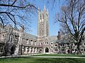
Holder Tower in Princeton University, one of the world's most prominent research universities
.jpg)
See also
 In Spanish: Condado de Mercer (Nueva Jersey) para niños
