
Cotuí facts for kids
Quick facts for kids
Cotuí
|
||
|---|---|---|
|
Municipality
|
||
|
||
| Country | ||
| Province | Sánchez Ramírez | |
| Founded | 1505 | |
| Municipality since | 1844 |
|
| Municipal Districts | Quita Sueño, Caballero, Comedero Arriba, Platanal | |
| Area | ||
| • Total | 474.6 km2 (183.2 sq mi) | |
| • Urban | 8.99 km2 (3.47 sq mi) | |
| Elevation | 83 m (272 ft) | |
| Population
(2014)
|
||
| • Total | 64,133 | |
| • Density | 135.131/km2 (349.99/sq mi) | |
| • Urban | 45,135 | |
| Demonym(s) | Cotuisano (female, cotuisana) | |
| Time zone | UTC-4 (AST) | |
| • Summer (DST) | UTC-4 (AST) | |
| Distance: | 55 km (34 mi) to La Vega 105 km (65 mi) to Santo Domingo |
|

Cotuí is a Dominican city and the head municipality of the Sánchez Ramírez province, in the centre of the country.
Name
Cotuí comes from the word Cotoi, the Taíno name of the region where the old city was founded.
History
The town was founded in 1505 by Rodrigo Mejía de Trujillo, a Spanish conquistador; the Spanish governor of the Hispaniola island at that time was Nicolás de Ovando. It was built near a gold mine in a region called Cotoi (also written Cotoy) by the Taíno people.
The old town was near the present town of Maimón and there were important improvements in the town during those first years and its named was changed to La Mejorada Villa de Cotuí ("The Improved City of Cotu") but most people called it Los Mineros ("The Miners").
In 1562 there was a strong earthquake that destroyed the town and other cities in the island. Cotuí was moved to its present place in 1569, close to the river Yuna.
It was made a municipality in 1822 by the Haitian government and it was one of the first municipalities of the country after the Dominican Independence in 1844. In 1952, Cotuí was made the head municipality of the new province of Sánchez Ramírez.
Population
The municipality had, in 2014, a total population of 64,133: 32,675 men and 31,458 women. The urban population was 70.4% of the total population.
Geography
Cotuí has a total area of 474.6 km2 (183 sq mi), about 40% of the total area of the province of Sánchez Ramírez. The city is an elevation of 83 m (272 ft), and at 105 km (65 mi) to the north of Santo Domingo.
Cotuí is to the north of the Sierra de Yamasá mountain range, in the Cibao Valley. The city is near the Yuna river, one of the most important river of the Hispaniola island.
The municipality of Cotuí has the Monseñor Nouel province to the west, the Monte Plata province to the south, the municipality of Fantino to the northwest, the municipality of La Mata to the north and the municipality of Cevicos to the west.
Climate
Cotuí has a tropical wet climate (Köppen-Geiger classification: Af) with no dry or cold season as it is constantly moist (rainfalls during the whole year).
The average amount of rainfall for the year in the city is 1,843.4 mm (72.6 in). The month with the most precipitation on average is May with 234.2 mm (9.2 in) of rainfall, followed by August with 209.1 mm (8.2 in).
The driest season is winter. The month with the least rainfall on average is January with an average of 88.2 mm (3.5 in) and the second is February with 98 mm (3.9 in).
Cotuí is in a hot region; the average temperature for the year is 26.3 °C (79.3 °F). The warmest month, on average, is June with an average temperature of 27.55 °C (81.6 °F). The coolest month on average is January, with an average temperature of 24.05 °C (75.3 °F).
| Climate data for Cotuí (1961–1990) | |||||||||||||
|---|---|---|---|---|---|---|---|---|---|---|---|---|---|
| Month | Jan | Feb | Mar | Apr | May | Jun | Jul | Aug | Sep | Oct | Nov | Dec | Year |
| Average high °C (°F) | 29.6 (85.3) |
30.4 (86.7) |
31.5 (88.7) |
32 (90) |
32.4 (90.3) |
33.1 (91.6) |
32.9 (91.2) |
33 (91) |
33.3 (91.9) |
33 (91) |
31.3 (88.3) |
29.6 (85.3) |
31.8 (89.3) |
| Daily mean °C (°F) | 24.1 (75.4) |
24.6 (76.3) |
25.7 (78.3) |
26.3 (79.3) |
27 (81) |
27.6 (81.7) |
27.5 (81.5) |
27.5 (81.5) |
27.5 (81.5) |
27.2 (81.0) |
26 (79) |
24.4 (75.9) |
26.3 (79.4) |
| Average low °C (°F) | 18.5 (65.3) |
18.8 (65.8) |
19.8 (67.6) |
20.5 (68.9) |
21.5 (70.7) |
22 (72) |
22.1 (71.8) |
22 (72) |
21.7 (71.1) |
21.4 (70.5) |
20.6 (69.1) |
19.1 (66.4) |
20.7 (69.3) |
| Average rainfall mm (inches) | 88.2 (3.47) |
98 (3.9) |
105.8 (4.17) |
126.7 (4.99) |
234.2 (9.22) |
149.6 (5.89) |
189.9 (7.48) |
209.1 (8.23) |
164.1 (6.46) |
161.2 (6.35) |
167.7 (6.60) |
148.9 (5.86) |
1,843.4 (72.62) |
| Source 1: NOAA | |||||||||||||
| Source 2: Climatemps.com | |||||||||||||
Administrative division
The municipality of Cotuí has four municipal districts:
| Code | Municipal district | Population (2010) |
|---|---|---|
| 240102 | Quita Sueño | 3,531 |
| 240103 | Caballero | 2,521 |
| 240104 | Comedero Arriba | 2,699 |
| 240105 | Platanal | 3,670 |
| Provincial capitals of the Dominican Republic | |
|---|---|
| Azua • Baní • Barahona • Bonao • Comendador • Cotuí • Dajabón • El Seibo • Hato Mayor • Higüey • Jimaní • La Romana • La Vega • Mao • Moca • Monte Cristi • Monte Plata • Nagua • Neiba • Pedernales • Puerto Plata • Sabaneta • Salcedo • Samaná • San Cristóbal • San Francisco de Macorís • San José de Ocoa • San Juan de la Maguana • San Pedro de Macorís • Santiago de los Caballeros • Santo Domingo • Santo Domingo Este | |
Images for kids
-
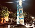
Cotui, Dominican Republic church and obelisk.
-
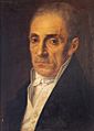
Juan Sánchez Ramírez


See also
 In Spanish: Cotuí para niños
