
Monroe County, Pennsylvania facts for kids
Quick facts for kids
Monroe County
|
|
|---|---|

Monroe County Courthouse
|
|

Location within the U.S. state of Pennsylvania
|
|
 Pennsylvania's location within the U.S. |
|
| Country | |
| State | |
| Founded | April 1, 1836 |
| Named for | James Monroe |
| Seat | Stroudsburg |
| Largest borough | East Stroudsburg |
| Area | |
| • Total | 617 sq mi (1,600 km2) |
| • Land | 608 sq mi (1,570 km2) |
| • Water | 9.0 sq mi (23 km2) 1.5%% |
| Population
(2020)
|
|
| • Total | 168,327 |
| • Density | 277/sq mi (107/km2) |
| Time zone | UTC−5 (Eastern) |
| • Summer (DST) | UTC−4 (EDT) |
| Congressional districts | 7th, 8th |
| Website | http://www.monroecountypa.gov |
Monroe County is a county in the U.S. Commonwealth of Pennsylvania. As of the 2010 census, the population was 168,327. Its county seat is Stroudsburg. The county was formed from sections of Northampton and Pike counties on April 1, 1836. Named in honor of James Monroe, the fifth president of the United States, the county is located in northeastern Pennsylvania, along its border with New Jersey. Monroe County is coterminous with the East Stroudsburg, PA Metropolitan Statistical Area. It also borders the Wyoming Valley, the Lehigh Valley and has connections to the Delaware Valley and the Tri-State Area being a part of New York City's Designated Media Market, but also receiving media from the Scranton/Wilkes-Barre and Philadelphia areas.
The county is home to East Stroudsburg University. For many recent decades, Monroe County was one of the fastest-growing counties in the state of Pennsylvania, partially due to tourism, and partially due to transplants from the New York City Area desiring a lower cost of living while still being close enough to commute to work in the city. The population increased by over 70% from 1990 to 2010, and the commercial and retail sectors expanded significantly, although population growth has since slowed.
Contents
Geography
According to the U.S. Census Bureau, the county has a total area of 617 square miles (1,600 km2), of which 608 square miles (1,570 km2) is land and 9.0 square miles (23 km2) (1.5%) is water.
Adjacent counties
- Wayne County (north)
- Pike County (northeast)
- Sussex County, New Jersey (northeast)
- Warren County, New Jersey (east)
- Northampton County (south)
- Carbon County (west)
- Luzerne County (northwest)
- Lackawanna County (northwest)
National protected areas
Demographics
As of the census of 2010, there were 169,842 people, 49,454 households, and 36,447 families residing in the county. The population density was 228 people per square mile (88/km2). There were 67,581 housing units at an average density of 111 per square mile (43/km2). The racial makeup of the county was 70.5% White Non-Hispanic, 13.2% Black or African American, 0.3% Native American, 2.1% Asian, 0.03% Pacific Islander, 4.3% from other races, and 2.9% from two or more races. 13.1% of the population were Hispanic or Latino of any race. 19.9% were of German, 16.8% Irish, 14.5% Italian, 8.8% Pennsylvania German, 5.4% Polish, 5.1% American and 5.1% English ancestry.
There were 49,454 households, out of which 36.20% had children under the age of 18 living with them, 60.70% were married couples living together, 8.80% had a female householder with no husband present, and 26.30% were non-families. 20.20% of all households were made up of individuals, and 7.80% had someone living alone who was 65 years of age or older. The average household size was 2.73 and the average family size was 3.16.
As of Q4 2021, the median value of all homes in Monroe County was $210,972, an increase of 13% since the prior year.
In the county, the population was spread out, with 26.80% under the age of 18, 8.60% from 18 to 24, 28.80% from 25 to 44, 23.50% from 45 to 64, and 12.30% who were 65 years of age or older. The median age was 37 years. For every 100 females there were 97.60 males. For every 100 females age 18 and over, there were 94.40 males.
Metropolitan Statistical Area

The United States Office of Management and Budget has designated Monroe County of Pennsylvania as the East Stroudsburg, PA Metropolitan Statistical Area. As of the 2010 United States Census the Metro area had a population of 169,842. The area ranks 12th most populous in the state of Pennsylvania and ranks 244th most populous in the United States.
The United States Office of Management and Budget also has designated Monroe County as part of the larger New York-Newark, NY-NJ-CT-PA Combined Statistical Area. The larger combined area consists of the Lehigh Valley counties of Carbon, Lehigh and Northampton as well as Pike County in Pennsylvania, and several other Metro areas from the States of New Jersey and New York. As of the 2010 US Census, the population of the CSA was 23,076,664, making it the most populous Combined Statistical Area in the United States.
Transportation
Public transportation throughout the county is provided by the Monroe County Transit Authority (MCTA), known as the "Pocono Pony". MCTA operates a fixed route bus system and a paratransit curb to curb service for eligible populations.
New Jersey Transit is restoring train tracks in northwestern New Jersey along the Lackawanna Cut-off. This would, potentially, also involve the train to go to Scranton from Hoboken (which would go through the Poconos), marking the first time since the early 1970s when the Erie Lackawanna Railroad stopped running daily trains through the area.
Major highways
 I-80
I-80 I-380
I-380 US 209


US 209 Bus. PA 33
PA 33 PA 115
 PA 191
 PA 196
 PA 314
 PA 390
 PA 402
 PA 423
 PA 447
 PA 534
 PA 611
 PA 715
 PA 903
 PA 940
Other Notable Resources
In addition to its rich cultural heritage, Monroe County is home to much of the Pennsylvania portion of the Delaware Water Gap National Recreation Area, Sullivan Trail (The portion of the route of General John Sullivan's famous march of 1778 from Easton to New York that reaches from Tannersville to Pocono Pines. This trail leads to the road that scales Big Pocono Mountain, one of the highest points in the Poconos that offers magnificent vistas.), Sanofi Pasteur (manufacturer of vaccines), Pocono Raceway (home of two major NASCAR events held annually), Camelbeach Water Park and Camelback Ski Area, Shawnee Mountain Ski Area, The Crossings Premium Outlets (named the number one outlet center in North America by the Outlet Retail Merchants Association (ORMA) for 2000–2001), three state parks (Big Pocono State Park, Gouldsboro State Park and Tobyhanna State Park), and Tobyhanna Army Depot (a major element of the Communications-Electronics Command and the largest Communications-Electronics repair, overhaul and fabrication facility in the Department of Defense).
Communities

Under Pennsylvania law, there are four types of incorporated municipalities: cities, boroughs, townships, and, in at most two cases, towns. The following cities, boroughs and townships are located in Monroe County:
Boroughs
- Delaware Water Gap
- East Stroudsburg
- Mount Pocono
- Stroudsburg (county seat)
Townships
- Barrett
- Chestnuthill
- Coolbaugh
- Eldred
- Hamilton
- Jackson
- Middle Smithfield
- Paradise
- Pocono
- Polk
- Price
- Ross
- Smithfield
- Stroud
- Tobyhanna
- Tunkhannock
Census-designated places
Census-designated places are geographical areas designated by the U.S. Census Bureau for the purposes of compiling demographic data. They are not actual jurisdictions under Pennsylvania law.
- Arlington Heights
- Brodheadsville
- Effort
- Emerald Lakes
- Gouldsboro
- Indian Mountain Lake (partially in Carbon County)
- Mountainhome
- Penn Estates
- Pocono Pines
- Saw Creek (mostly in Pike County)
- Saylorsburg
- Sierra View
- Sun Valley
Unincorporated communities
- Analomink
- Appenzell
- Bartonsville
- Blakeslee
- Bossardsville
- Canadensis
- Cherry Valley
- Cresco
- Gilbert
- Gravel Place
- Hamilton Square
- Henryville
- Jonas
- Kellersville
- Kemmertown
- Kresgeville
- Kunkletown
- Long Pond
- Marshalls Creek
- McIlhaney
- McMichaels
- Meistertown
- Neola
- Paradise Valley
- Pocono Manor
- Pocono Summit
- Reeders
- Sciota
- Scotrun
- Shawnee on Delaware
- Skytop
- Snydersvillle
- South Stroudsburg
- Swiftwater
- Tannersville
- Tobyhanna
Population ranking
The population ranking of the following table is based on the 2010 census of Monroe County.
† county seat
| Rank | City/Town/etc. | Municipal type | Population (2010 Census) |
|---|---|---|---|
| 1 | East Stroudsburg | Borough | 9,840 |
| 2 | Arlington Heights | CDP | 6,333 |
| 3 | † Stroudsburg | Borough | 5,567 |
| 4 | Sierra View | CDP | 4,813 |
| 5 | Penn Estates | CDP | 4,493 |
| 6 | Indian Mountain Lake (partially in Carbon County) | CDP | 4,372 |
| 7 | Saw Creek (mostly in Pike County) | CDP | 4,016 |
| 8 | Mount Pocono | Borough | 3,170 |
| 9 | Emerald Lakes | CDP | 2,886 |
| 10 | Sun Valley | CDP | 2,399 |
| 11 | Effort | CDP | 2,269 |
| 12 | Brodheadsville | CDP | 1,800 |
| 13 | Pocono Pines | CDP | 1,409 |
| 14 | Mountainhome | CDP | 1,182 |
| 15 | Saylorsburg | CDP | 1,126 |
| 16 | Gouldsboro (mostly in Wayne County) | CDP | 890 |
| 17 | Delaware Water Gap | Borough | 746 |
Education

Colleges and universities
- East Stroudsburg University of Pennsylvania
- Northampton Community College (Monroe Campus)
Public school districts
- East Stroudsburg Area School District
- Pleasant Valley School District
- Pocono Mountain School District
- Stroudsburg Area School District
Charter schools
- Evergreen Community Charter School, Cresco
Technology schools
Private schools
- Art Learning Center, East Stroudsburg
- Character Builders Christian Academy, Pocono Pines
- East Stroudsburg Christian Academy, East Stroudsburg **closed in 2012** Monsignor McHugh School, Cresco **closed in 2020** Notre Dame Elementary School, East Stroudsburg
- Notre Dame High School, East Stroudsburg
- Pocono Central Catholic High School, Cresco **closed in 1988** St Pauls Lutheran Pre-School, East Stroudsburg
- Stroudsburg 7th Day Adventists School, Stroudsburg
- Summit School of the Poconos, Stroudsburg
- Triumphant & Excellence Academy 1, East Stroudsburg
- Triumphant & Excellence Academy 2 TEA Institute, Tobyhanna
- Triumphant Living Heritage, Marshalls Creek
- Victory Baptist Christian School, Brodheadsville
Private schools are as reported in EdNA school database maintained and published by the Pennsylvania Department of Education, 2011
Images for kids
-
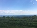
The view from Big Pocono State Park at Camelback Mountain
-
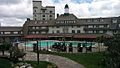
Inn At Pocono Manor (May 2015)
-
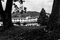
The Shawnee Inn


See also
 In Spanish: Condado de Monroe (Pensilvania) para niños
