
Wyoming Valley facts for kids
Quick facts for kids
Wyoming Valley, PA MSA
|
|
|---|---|
| Scranton/Wilkes-Barre/Hazleton | |
    |
|

Location of the Scranton–Wilkes-Barre–Hazleton Metro Area within the State of Pennsylvania.
|
|
| Country | United States |
| State(s) | Pennsylvania |
| Largest city | Scranton |
| Other cities | - Wilkes-Barre - Hazleton - Carbondale - Pittston City (Greater Pittston) - Nanticoke |
| Area | |
| • Total | 1,776 sq mi (4,600 km2) |
| Highest elevation | 2,460 ft (750 m) |
| Lowest elevation | 400 ft (100 m) |
| Population | |
| • Total | 567,559 |
| • Rank | 100th in the U.S. |
The Wyoming Valley is a historic industrialized region of Northeastern Pennsylvania, historically notable for fueling the American Industrial Revolution in the United States with its many anthracite coal-mines. As a metropolitan area, it is known as the Scranton/Wilkes-Barre metropolitan area, after its principal cities, Scranton and Wilkes-Barre. With a population of 567,559 as of the 2020 United States census, it is the fifth-largest metropolitan area in Pennsylvania, after the Delaware Valley, Greater Pittsburgh, the Lehigh Valley, and the Harrisburg–Carlisle metropolitan statistical areas.
Within the geology of Pennsylvania the Wyoming Valley makes up its own unique physiographic province, the Anthracite Valley. Greater Pittston occupies the center of the valley. Scranton is the most populated city in the metropolitan area with a population of 77,114. The city of Scranton grew in population after the 2015 mid-term census while Wilkes-Barre declined in population. Wilkes-Barre remains the second most-populated city in the metropolitan area, while Hazleton is the third most-populated city in the metropolitan area.
The valley is a crescent-shaped depression, a part of the ridge-and-valley or folded Appalachians. The Susquehanna River occupies the southern part of the valley, which is notable for its deposits of anthracite. These have been extensively mined. Deep mining of anthracite has declined throughout the greater Coal Region, however, due to the greater economics of strip mining. Parts of the local mines had already shut down because some coal beds were on fire and had to be sealed; but the exodus of mining companies came quickly following the legal and political repercussions of the 1959 Knox Mine Disaster—when the roof of the Knox Coal Company's mine under the Susquehanna River collapsed. The Pocono Mountains, a ridgeline away, are often visible from higher elevations to the east and to the southeast of the Wyoming Valley.
Contents
Metropolitan Statistical Area
The Scranton–Wilkes-Barre–Hazleton, PA Metropolitan Statistical Area covers Lackawanna, Luzerne, and Wyoming counties. It had a combined population of 558,166 in 2015. The counties adjacent to the "Wyoming Valley" include Monroe County (Southeast), Susquehanna County (Northeast), Wayne County (East), Columbia County (West), Bradford County (Northwest), Carbon County (South), Sullivan County (West) and Schuylkill County (Southeast). The area also has the highest percentage of non-Hispanic whites of any U.S. metropolitan area with a population over 500,000, with 96.2% of the population stating their race as white alone and not claiming Hispanic ethnicity.
When metropolitan areas were first defined in 1950, Scranton and Wilkes-Barre were in separate metropolitan areas. Lackawanna County was defined as the Scranton Standard Metropolitan Area, while Luzerne County was defined as the Wilkes-Barre–Hazleton Standard Metropolitan Area. The two metropolitan areas were merged after the 1970 census as the Northeast Pennsylvania Standard Metropolitan Statistical Area, with Monroe County added as a component. It was renamed the Scranton/Wilkes-Barre Metropolitan Statistical Area after the 1980 census, and Columbia and Wyoming counties were added. Hazleton was added as a primary city in the 1990 census, while Monroe County lost its metropolitan status. After the 2000 census, Columbia County lost metropolitan status, while Hazleton was removed as a primary city. Scranton is the largest city in Lackawanna County as well as the entire metropolitan area by a large margin, nearly doubling the population of the second largest city in the metropolitan area (Wilkes-Barre).
| County | 2015 Population | 2010 Population | Area |
|---|---|---|---|
| Lackawanna County | 211,917 | 214,437 | 465 sq mi (1,204 km2) |
| Luzerne County | 318,449 | 320,918 | 906 sq mi (2,350 km2) |
| Wyoming County | 27,800 | 28,276 | 405 sq mi (1,049 km2) |
| Total | 558,166 | 563,631 | 1,776 sq mi (4,600 km2) |
Yellow: the largest county by area and population
History
.jpg)
.jpg)
The name Wyoming derives from the Lenape Munsee name xwé:wamənk, meaning "at the smaller river hills."
According to the Jesuit Relation of 1635, the Wyoming Valley was inhabited by the Scahentoarrhonon people, an Iroquoian-speaking group; it was then known as the Scahentowanen Valley. By 1744 it was inhabited by Lenape, Mahican, Shawnee and others who had been pushed out of eastern areas by the Iroquois Confederacy. From the 1740s to the 1760s, the valley was the site of Moravian mission work among the Native Americans living there. They envisioned a settlement for Christian Indians. But the violence of the French and Indian War, the North American front of the Seven Years' War, drove these settlers away with David Zeisberger, the Moravian "Apostle to the Indians."
Pennsylvania's and Connecticut's conflicting claims to the territory — King Charles II of England had granted the land to the colony of Connecticut in 1662, and also to William Penn in 1681 — led to military skirmishes known as the Pennamite Wars. After Yankee settlers from Connecticut founded the town of Wilkes-Barre in 1769, armed bands of Pennsylvanians (Pennamites) tried without success to expel them in 1769-70, and again in 1775.
During the American Revolutionary War, the Battle of Wyoming took place here on July 3, 1778, in which more than 300 Revolutionaries died at the hands of Loyalists and their Iroquois allies. The incident was depicted by the Scottish poet Thomas Campbell in his 1809 poem Gertrude of Wyoming. At the time, rebel colonists widely believed that Joseph Brant, a Mohawk chief, had led the Iroquois forces; in the poem, Brant is described as the "Monster Brant" because of the atrocities committed. Later colonists determined that Brant had not been present at this conflict. The popularity of the poem may have led to the state of Wyoming later being named after the valley.
Culture
Sports
The Wyoming Valley also has professional sports teams; they include the Scranton/Wilkes-Barre Railriders (Baseball AAA), the Wilkes-Barre/Scranton Penguins (Hockey AHL), and the Scranton/Wilkes-Barre Steamers(Basketball Premier Basketball League).
Local attractions
Local attractions include the Mohegan Sun Arena at Casey Plaza in Wilkes-Barre, the Pocono Raceway in Long Pond, PNC Field in Moosic, Mohegan Sun at Pocono Downs in Plains, the Toyota Pavilion in Scranton, the Wyoming Valley Mall in Wilkes-Barre, the Shoppes at Montage in Moosic, the Steamtown Mall in Scranton, the Viewmont Mall in Scranton/Dickson City, Pennsylvania, and the Montage Mountain Waterpark/Ski Resort in Scranton. Other historic attractions include Eckley Miners' Village and the Steamtown National Historic Site.


Transportation
The airports for this area are Wilkes-Barre/Scranton International Airport and the Wilkes-Barre Wyoming Valley Airport.
Images for kids
-
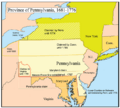
A map of Pennsylvania and the competing land claims

See also
 In Spanish: Área metropolitana de Scranton-Wilkes-Barre para niños
