
Luzerne County, Pennsylvania facts for kids
Quick facts for kids
Luzerne County, Pennsylvania
|
||
|---|---|---|
|
||

Topographical map of Luzerne County
|
||

Location in the U.S. state of Pennsylvania
|
||
| Country | United States | |
| State | ||
| Region | Northeastern Pennsylvania | |
| Metro area | Wyoming Valley | |
| Formed | September 25, 1786 | |
| Named for | Chevalier de la Luzerne | |
| County seat | Wilkes-Barre | |
| Largest city | Wilkes-Barre | |
| Government | ||
| • Type | Council–manager | |
| Area | ||
| • Total | 906 sq mi (2,350 km2) | |
| • Land | 890 sq mi (2,300 km2) | |
| • Water | 16 sq mi (40 km2) | |
| Highest elevation | 2,460 ft (750 m) | |
| Lowest elevation | 512 ft (156 m) | |
| Population
(2020)
|
||
| • Total | 325,594 | |
| • Estimate
(2020)
|
325,594 | |
| • Density | 359.38/sq mi (138.76/km2) | |
| Time zone | UTC−5 (EST) | |
| • Summer (DST) | UTC−4 (EDT) | |
| Area codes | 570/272 | |

Luzerne County is a county in the Commonwealth of Pennsylvania. According to the U.S. Census Bureau, the county has a total area of 906 square miles (2,350 km2), of which 890 square miles (2,300 km2) is land and 16 square miles (41 km2) is water. It is Northeastern Pennsylvania's second-largest county by total area. As of the 2020 census, the population was 325,594, making it the most populous county in the northeastern part of the state. The county seat and largest city is Wilkes-Barre. Other populous communities include Hazleton, Kingston, Nanticoke, and Pittston. Luzerne County is included in the Scranton–Wilkes-Barre–Hazleton Metropolitan Statistical Area, which has a total population of 555,426 (as of 2017).
On September 25, 1786, Luzerne County was formed from part of Northumberland County. It was named after Chevalier de la Luzerne, a French soldier and diplomat during the 18th century. When it was founded, Luzerne County occupied a large portion of Northeastern Pennsylvania. From 1810 to 1878, it was divided into several smaller counties. The counties of Bradford, Lackawanna, Susquehanna, and Wyoming were all formed from parts of Luzerne County.
The county gained prominence in the 19th and 20th centuries as an active anthracite coal mining region, drawing a large portion of its labor force from European immigrants. At its peak (in 1930), the county's population was 445,109. By the early 21st century, many factories and coal mines were closed. Like most counties in the Rust Belt, Luzerne witnessed population loss and urban decay. However, the economy has grown moderately in recent years; warehousing has replaced manufacturing as the main industry.
Contents
History


The Luzerne County Historical Society maintains the storehouse for the collective memory of Luzerne County and its environs. It records and interprets the history, traditions, events, people and cultures that have directed and molded life within the region.
18th century
- 1769: The Pennamite-Yankee War (or the Yankee-Pennamite Wars) began when settlers from Connecticut and Pennsylvania fought over land claims along the North Branch of the Susquehanna River in the present Wyoming Valley.
- July 1, 1778: During the Revolutionary War, Fort Jenkins (a patriot stockade in present-day West Pittston) was surrendered to the British (under Major John Butler). It was later burned to the ground. In 1928, a bridge connecting West Pittston and Pittston City was constructed and named in its honor.
- July 3, 1778: A force of British soldiers, led by John Butler, with the assistance of about 700 Indians, attacked and killed nearly 300 Wyoming Valley settlers. Today in the Borough of Wyoming, a monument marks the gravesite of the victims from the Battle of Wyoming.
- July 4, 1778: Fort Pittston (located in what is now Pittston City) surrendered to the British and some of it was partially destroyed. It was later restored and used until the end of the Revolutionary War.
- September 1778: Revenge for the Wyoming defeat was taken by American Colonel Thomas Hartley who, with 200 soldiers, burned nine to twelve Seneca, Delaware and Mingo villages along the Susquehanna River in northeast Pennsylvania, including Tioga and Chemung.
- September 11, 1780: Reports of Tory activity in the region caused Captain Daniel Klader and a platoon of 40 to 50 men from Northampton County, Pennsylvania, to investigate. Captain Klader's men made it as far north as present-day Conyngham, when they were ambushed by the Seneca nation and by the Tories. 18 of Klader's men were killed in what is known as the Sugarloaf Massacre.
- September 25, 1786: Luzerne County was formed from part of Northumberland County. It was named after Chevalier de la Luzerne, French ambassador to the United States.
19th century
- September 6, 1869: A mine fire killed 110 people in Avondale, an unincorporated community in Plymouth Township.
- June 28, 1896: The Newton Coal Company's Twin Shaft Mine in Pittston City caved-in and killed 58 miners.
- September 10, 1897: Sheriff James Martin formed a posse and fired on a group of unarmed miners in what is known today as the Lattimer massacre. Luzerne is infamous for being the last county whose sheriff legally formed a posse to restore order in a time of civil unrest.
20th century
- 1908 – 1912: The anthracite coal mining industry, and its extensive use of child labor in the early part of the 20th century, was one of the industries targeted by the National Child Labor Committee and its hired photographer, Lewis Hine. Many of Hine's subjects were photographed in the mines and coal fields in and around Pittston during this time. The impact of the Hine photographs led to the enactment of child labor laws across the country.
- 1915: A mine fire in Laurel Run, Pennsylvania, caused a section of the town to be relocated.
- June 5, 1919: An explosion at the Baltimore Colliery in Wilkes-Barre, Pennsylvania, killed 92 miners.
- 1930s – 1980s: Pittston City emerged as a national center for clothing manufacturing. Thousands of workers, mainly women, labored in many factories throughout the Greater Pittston area. One such woman was Susan Sebastianelli of Pittston Township. Most were members of the International Ladies' Garment Workers' Union (ILGWU) that gained higher wages, workplace health & safety improvements, and employee rights. The ILGWU was active in civic and political life throughout Pennsylvania.
- 1934: The right arm of Hughestown, Pennsylvania, resident, Harry Tompkins, was crushed by an Erie Railroad train. This resulted in the U.S. Supreme Court case, Erie Railroad Co. v. Tompkins, which laid the foundation for a large part of modern American civil procedure.
- January 22, 1959: The Knox Mine disaster in Port Griffith, Jenkins Township, claimed the lives of 12 people and essentially shut down the mining industry in Northeastern Pennsylvania.
- June 1972: Hurricane Agnes was responsible for massive flooding in and around Wilkes-Barre, Pennsylvania.
- 1974–1989: Alleged ghost hauntings took place in the home of Jack and Janet Smurl in West Pittston. This resulted in the 1991 film The Haunted.
- 1992: The opening scenes from the movie School Ties was filmed in West Pittston; it shows David Green, the hero of the movie (played by Brendan Fraser), hanging out with friends in the streets of the tiny town.
21st century
- May 21, 2000: A plane crash in Bear Creek Township, Pennsylvania, near the intersection of Bear Creek Boulevard (PA-Route 115) and the Northeast Extension of the Pennsylvania Turnpike, killed the pilot as well as all 19 passengers.
- December 1, 2006: A tornado left a path of destruction approximately 15 miles (24 km) long (this included parts of Mountain Top).
- 2008: The Kids for Cash scandal resulted in federal convictions and sentences of juvenile court judges Mark Ciavarella and Michael Conahan.
- 2011: The Borough of Duryea received national attention for its role in the landmark Supreme Court case Borough of Duryea v. Guarnieri, in which the court stated that "a government employer's allegedly retaliatory actions against an employee do not give rise to liability under the Petition Clause unless the employee's petition relates to a matter of public concern."
- September 2011: Luzerne County witnessed historical flooding from Tropical Storm Lee. The Susquehanna River reached a record high of 42.6 feet (13 meters) in Wilkes-Barre. The river topped the 40.9-foot (12.5 meters) level in flooding caused by Hurricane Agnes in 1972. The Greater Pittston, Wilkes-Barre, and Nanticoke areas were hit the hardest.
- January 2, 2012: A new county government was formed. The first members of the Luzerne County Council were sworn in. The first council chair was Jim Bobeck. The following month, the council appointed the first county manager (Robert Lawton).
Geography


According to the U.S. Census Bureau, the county has a total area of 906 square miles (2,350 km2), of which 890 square miles (2,300 km2) is land and 16 square miles (41 km2) (1.8%) is water. The highest point in the county is Cherry Ridge in Fairmount Township. The ridge is 2,460 feet (750 m) above sea level. The lowest point, of about 512 feet (156 m), can be found near Shickshinny.
The Wyoming Valley is located in the north and mid part of the county. The valley is flat (at the Susquehanna Basin) and rises from 512 feet (156 m) to 2,000 feet (610 m) in some places. Bear Creek, on the eastern side of the valley, has a mean elevation of about 2,000 feet (610 m), while Shickshinny, on the Susquehanna Basin, is about 512 feet (156 m). The Wyoming Valley (in Luzerne County) extends from Exeter Township and Pittston Township to Shickshinny and Salem Township. Pittston City, West Pittston Borough, Wyoming Borough, Kingston Borough, and Wilkes-Barre City all make up the Susquehanna Basin of the Wyoming Valley. Greater Pittston makes up the northeastern region of the county. The county is crossed by a series of east-to-west mountains. The Susquehanna River drains most of the county while the Lehigh River drains some eastern and southeastern portions. The Lehigh forms part of Luzerne County's southeastern border.
Luzerne County consists of several urban areas. The first is a contiguous quilt-work of former anthracite coal mining communities (including the cities of Pittston, Wilkes-Barre, and Nanticoke). It is located in the northeastern and central part of the county. The second is Hazleton and it is located in the southern portion of the county. Other smaller urban areas (such as the Back Mountain and Mountain Top) are scattered throughout the region. Small farming communities can be found outside of the urban centers.
Adjacent counties
- Wyoming County (north)
- Lackawanna County (northeast)
- Monroe County (east)
- Carbon County (southeast)
- Schuylkill County (south)
- Columbia County (west)
- Sullivan County (northwest)
Major highways
Airports
- Wilkes-Barre/Scranton International Airport
- Wilkes-Barre Wyoming Valley Airport
- Hazleton Municipal Airport

.jpg)


Demographics

| Historical population | |||
|---|---|---|---|
| Census | Pop. | %± | |
| 1790 | 4,892 | — | |
| 1800 | 12,839 | 162.4% | |
| 1810 | 18,109 | 41.0% | |
| 1820 | 20,027 | 10.6% | |
| 1830 | 27,379 | 36.7% | |
| 1840 | 44,006 | 60.7% | |
| 1850 | 56,072 | 27.4% | |
| 1860 | 90,244 | 60.9% | |
| 1870 | 160,915 | 78.3% | |
| 1880 | 133,065 | −17.3% | |
| 1890 | 201,203 | 51.2% | |
| 1900 | 257,121 | 27.8% | |
| 1910 | 343,186 | 33.5% | |
| 1920 | 390,991 | 13.9% | |
| 1930 | 445,109 | 13.8% | |
| 1940 | 441,518 | −0.8% | |
| 1950 | 392,241 | −11.2% | |
| 1960 | 346,972 | −11.5% | |
| 1970 | 342,301 | −1.3% | |
| 1980 | 343,079 | 0.2% | |
| 1990 | 328,149 | −4.4% | |
| 2000 | 319,255 | −2.7% | |
| 2010 | 320,918 | 0.5% | |
| 2020 | 325,594 | 1.5% | |
| Sources: | |||
As of the 2020 census, the county was 89.3% White, 6.6% Black or African American, 0.7% Native American, 1.4% Asian, and 2.0% were of two or more races. 13.8% of the population were of Hispanic or Latino ancestry.
According to the 2010 census, the county was 90.7% White, 3.4% Black or African American, 0.2% Native American, 1.0% Asian, 3.3% other race, and 1.5% were of two or more races. 6.7% of the population were of Hispanic or Latino ancestry.
According to the census of 2000, there were 319,250 people, 130,687 households, and 84,293 families residing in the county. The population density was 358 people per square mile (138/km2). There were 144,686 housing units at an average density of 162 per square mile (63/km2). The racial makeup of the county was 96.63% White, 1.69% Black or African American, 0.09% Native American, 0.58% Asian, 0.01% Pacific Islander, 0.43% other race, and 0.57% from two or more races. 1.16% of the population were Hispanic or Latino. 22.2% were of Polish ancestry, 15.6% of Italian ancestry, 13.8% of Irish ancestry, 12.1% of German ancestry, and 5.3% of Slovak ancestry. Luzerne County is the only county in the United States with a plurality of citizens reporting Polish as their primary ancestry; the plurality of Pennsylvanians report German or Pennsylvania Dutch.
There were 130,687 households, out of which 48.80% were married couples living together. 11.50% had a female householder with no husband present. 35.50% were non-families. 31.30% of all households were made up of individuals. 16% of those age 65 years and older lived alone. The average household size was 2.34 and the average family size was 2.95.
In the county, the population consisted of 21% under the age of 18, 8.10% from 18 to 24, 27.20% from 25 to 44, 24% from 45 to 64, and 19.70% who were 65 years of age or older. The median age was 41 years. For every 100 females, there were 93 males. For every 100 females (age 18 and over), there were 89.50 males.
The median household income (in 2015 dollars) was $45,897. 15.1% of the population lives in poverty. 60.4% of those 16 years of age or older are in the civilian labor force. There are more white collar jobs in Luzerne County than blue collar jobs. In total, there are 91,801 white collar jobs and 62,813 blue collar jobs. The mean travel time to work (for those 16 years of age or older) was 22.1 minutes. In terms of education, 88.9% (of those 25 years of age or older) are high school graduates or higher. 21.4% (of those 25 years of age or older) have a bachelor's degree or higher. In terms of healthcare, 10.8% (for those under the age of 65) are living with a disability. As of 2015, 25,317 veterans are living in Luzerne County.
Languages
The two major languages spoken in Luzerne County are English and Spanish. 5.8% of the population speaks Spanish at home. Most of the Spanish speaking population can be found in and around the City of Hazleton.
Religion
59.27% of the people in Luzerne County are religious, meaning they affiliate with a religion. 43.77% are Catholic; 0.28% are LDS (or The Church of Jesus Christ of Latter-day Saints); 0.51% are Baptist; 0.55% are Episcopalian; 1.05% are Pentecostal; 3.11% are Lutheran; 4.40% are Methodist; 1.95% are Presbyterian; 2.33% are of some other Christian faith; 0.78% are Jewish; 0.00% are of an eastern faith; and 0.51% practice Islam.
Recreation

There are four Pennsylvania state parks in Luzerne County:
- Frances Slocum State Park (northern Luzerne County)
- Lehigh Gorge State Park (eastern Luzerne County)
- Nescopeck State Park (southern Luzerne County)
- Ricketts Glen State Park (western Luzerne County)
Other recreation
- Moon Lake Park (northern Luzerne County)
- Pinchot State Forest
- Seven Tubs Recreation Area
- Susquehanna Warrior Trail


Local attractions

- Bittenbender Covered Bridge
- Dorothy Dickson Darte Center for the Performing Arts, located on the campus of Wilkes University
- Eckley Miners' Village
- F.M. Kirby Center for the Performing Arts
- Frederick Stegmaier Mansion
- Little Theatre of Wilkes-Barre
- Luzerne County Museum
- Mohegan Sun Arena at Casey Plaza, home of the Wilkes-Barre/Scranton Penguins
- Mohegan Sun at Pocono Downs, Pennsylvania's first slots casino
- Swetland Homestead
- Wyoming Monument
- Wyoming Valley Mall
Communities


Luzerne County contains the second highest number of independently governing municipalities in the state of Pennsylvania, with 76; only Allegheny County has more. Under Pennsylvania law, there are four types of incorporated municipalities: cities, boroughs, townships, and, in the case of Bloomsburg, towns. The following cities, boroughs and townships are located in Luzerne County:
Cities
- Hazleton
- Nanticoke
- Pittston
- Wilkes-Barre (county seat)
Boroughs
- Ashley
- Avoca
- Bear Creek Village
- Conyngham
- Courtdale
- Dallas
- Dupont
- Duryea
- Edwardsville
- Exeter
- Forty Fort
- Freeland
- Harveys Lake
- Hughestown
- Jeddo
- Kingston
- Laflin
- Larksville
- Laurel Run
- Luzerne
- Nescopeck
- New Columbus
- Nuangola
- Penn Lake Park
- Plymouth
- Pringle
- Shickshinny
- Sugar Notch
- Swoyersville
- Warrior Run
- West Hazleton
- West Pittston
- West Wyoming
- White Haven
- Wyoming
- Yatesville
Townships
Census-designated places
Census-designated places are geographical areas designated by the U.S. Census Bureau for the purposes of compiling demographic data. They are not actual jurisdictions under Pennsylvania law.
Other places
- Back Mountain
- Breslau
- Cork Lane
- Drums
- Glendale
- Glen Summit Springs
- Greater Pittston
- Japan
- Kis-Lyn
- Koonsville
- Korn Krest
- Kunkle
- Mossville
- Mountain Grove
- Old Boston
- Port Griffith
- Suscon
- Sweet Valley
- Sybertsville
- Tomhicken
- Wapwallopen
- Waterton
- Zenith
Population ranking
The population ranking of the following table is based on the 2010 census of Luzerne County.
† county seat
| Rank | City/Town/etc. | Municipal type | Population (2010 Census) |
|---|---|---|---|
| 1 | † Wilkes-Barre | City | 41,498 |
| 2 | Hazleton | City | 25,340 |
| 3 | Kingston | Borough | 13,182 |
| 4 | Mountain Top | CDP | 10,982 |
| 5 | Nanticoke | City | 10,465 |
| 6 | Pittston | City | 7,739 |
| 7 | Plymouth | Borough | 5,951 |
| 8 | Exeter | Borough | 5,652 |
| 9 | Swoyersville | Borough | 5,062 |
| 10 | Duryea | Borough | 4,917 |
| 11 | West Pittston | Borough | 4,868 |
| 12 | Edwardsville | Borough | 4,816 |
| 13 | West Hazleton | Borough | 4,594 |
| 14 | Larksville | Borough | 4,480 |
| 15 | Plains | CDP | 4,335 |
| 16 | Forty Fort | Borough | 4,214 |
| 17 | Freeland | Borough | 3,531 |
| 18 | Wyoming | Borough | 3,073 |
| 19 | Luzerne | Borough | 2,845 |
| 20 | Dallas | Borough | 2,804 |
| 21 | Harveys Lake | Borough | 2,791 |
| 22 | Ashley | Borough | 2,790 |
| 23 | West Wyoming | Borough | 2,725 |
| 24 | Dupont | Borough | 2,711 |
| 25 | Avoca | Borough | 2,661 |
| 26 | Trucksville | CDP | 2,152 |
| 27 | Beech Mountain Lakes | CDP | 2,022 |
| 28 | Shavertown | CDP | 2,019 |
| 29 | East Berwick | CDP | 2,007 |
| 30 | Conyngham | Borough | 1,914 |
| 31 | Glen Lyon | CDP | 1,873 |
| 32 | Inkerman | CDP | 1,819 |
| 33 | Georgetown | CDP | 1,640 |
| 34 | Nescopeck | Borough | 1,583 |
| 35 | Laflin | Borough | 1,487 |
| 36 | Hudson | CDP | 1,443 |
| 37 | Browntown | CDP | 1,418 |
| 38 | Hughestown | Borough | 1,392 |
| 39 | Hilldale | CDP | 1,246 |
| 40 | Harleigh | CDP | 1,104 |
| 41 | White Haven | Borough | 1,097 |
| 42 | Sugar Notch | Borough | 989 |
| 43 | Pringle | Borough | 979 |
| 44 | Chase | CDP | 978 |
| 45 | Shickshinny | Borough | 838 |
| 46 | Silkworth | CDP | 820 |
| 47 | West Nanticoke | CDP | 749 |
| 48 | Courtdale | Borough | 732 |
| 49 | Upper Exeter | CDP | 707 |
| 50 | Nuangola | Borough | 679 |
| 51 | Sheatown | CDP | 671 |
| 52 | Mocanaqua | CDP | 646 |
| 53 | Wanamie | CDP | 612 |
| 54 | Yatesville | Borough | 607 |
| 55 | Warrior Run | Borough | 584 |
| 56 | Pardeesville | CDP | 572 |
| 57 | Hickory Hills | CDP | 562 |
| 58 | Lattimer | CDP | 554 |
| 59 | Laurel Run | Borough | 500 |
| 60 | Nuremberg (partially in Schuylkill County) | CDP | 434 |
| 61 | Weston | CDP | 321 |
| 62 | Penn Lake Park | Borough | 308 |
| 63 | Pikes Creek | CDP | 269 |
| 64 | Bear Creek Village | Borough | 257 |
| 65 | New Columbus | Borough | 227 |
| 66 | Jeddo | Borough | 98 |
Education


Public school districts
- Berwick Area School District (also in Columbia County)
- Crestwood School District
- Dallas School District
- Greater Nanticoke Area School District
- Hanover Area School District
- Hazleton Area School District (also in Carbon and Schuylkill Counties)
- Lake-Lehman School District (also in Wyoming County)
- Northwest Area School District
- Pittston Area School District
- Wilkes-Barre Area School District
- Wyoming Area School District (also in Wyoming County)
- Wyoming Valley West School District
Charter schools
- Bear Creek Community Charter School, Bear Creek Township
Public vocational technical schools
- West Side Career and Technology Center, Pringle
Private schools
- Graham Academy, Kingston
- Holy Cross High School, located in Lackawanna County; it serves Luzerne County residents
- Holy Redeemer High School, Wilkes-Barre
- Jenny Lynn Ferraro Academy, Kingston
- Milford E. Barnes Junior School, Wilkes-Barre
- MMI Preparatory School, Freeland
- New Story School, Wyoming
- Wilkes-Barre Academy, Wilkes-Barre
- Wyoming Seminary, Forty Fort and Kingston
Colleges and universities
- Geisinger Commonwealth School of Medicine, Wilkes-Barre
- King's College, Wilkes-Barre
- Luzerne County Community College, Nanticoke
- McCann School of Business & Technology, Wilkes-Barre
- Misericordia University, Dallas
- Penn State Hazleton, Hazleton
- Penn State Wilkes-Barre, Lehman Township
- Wilkes University, Wilkes-Barre
Libraries
The Luzerne County Library System includes the following locations:
- Back Mountain Memorial Library, Back Mountain
- Hazleton Area Public Library, Hazleton
- Hoyt Library, Kingston
- Marian Sutherland Kirby Library, Mountain Top
- Mill Memorial Library, Nanticoke
- Osterhout Free Library, Wilkes-Barre
- Pittston Memorial Library, Pittston
- Plymouth Public Library, Plymouth
- West Pittston Library, West Pittston
- Wyoming Free Library, Wyoming
Transportation

.jpg)
Highways
Railroads
- Canadian Pacific Railway (CP)
- Delaware and Hudson Railway (DH)
- Luzerne and Susquehanna Railway (LS)
- Norfolk Southern Railway (NS)
- North Shore Railroad (NSHR)
- Reading Blue Mountain and Northern Railroad (RBMN)
Airports
- Hazleton Municipal Airport
- Wilkes-Barre/Scranton International Airport
- Wilkes-Barre Wyoming Valley Airport
|
Interstate 80 in southern Luzerne County
|
Notable people
Images for kids
-
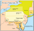
Map of the Province of Pennsylvania and competing land claims at the time
-
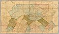
A 1792 map of Pennsylvania when Bradford, Lackawanna, Susquehanna, and Wyoming were still part of Luzerne County
-
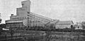
This coal breaker in Plymouth was built in 1869 and destroyed by fire in 1899.
-
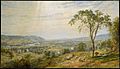
Wyoming Valley in the 1860s
-
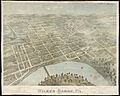
Wilkes-Barre in 1872
-
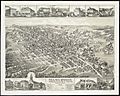
Hazleton in 1884
-
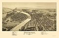
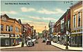
Pittston in 1892
-
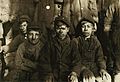
Breaker boys in Pittston, January 1911
-
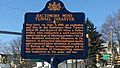
Historical marker of the June 5, 1919 Baltimore Mine Tunnel disaster in Wilkes-Barre
-
Nanticoke as depicted in a drawing from between 1930 and 1945
-
Ashley's abandoned Huber coal breaker, May 2008
-
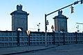
The levees and temporary flood walls that protected Wilkes-Barre from Tropical Storm Lee flooding in September 2011
-

Adams Falls, Ricketts Glen State Park
-

Grand View Trail, Ricketts Glen State Park
-
Hayfields, Ricketts Glen State Park
-

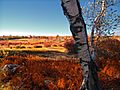
Summit of Mount Yeager, Nescopeck State Park
-
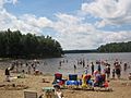
A beach on Lake Jean, July 2010
-

A volunteer fire department in Mocanaqua, November 2016
-
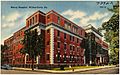
Mercy Hospital in Wilkes-Barre as depicted in drawing made between 1930 and 1945
-
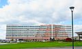
Mohegan Poconos hotel near the Mohegan Sun casino, October 2016
-
Wilkes-Barre's Public Square, August 2013
-
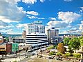
Wilkes-Barre, the county seat and largest city of Luzerne County


.jpg)
.jpg)


.jpg)


_(8213883793).jpg)
.jpg)
.jpg)


.jpg)


See also
 In Spanish: Condado de Luzerne para niños
